Posts Tagged With: history

Scattery Island, Co Clare. An Irish Time Capsule.

At the southern end of West Clare, on an island just off the coast near the town of Kilrush, lies one of country’s best kept secrets.  But that’s changing. The word is out. Last year it was awarded a prestigious European Destination of Excellence award for Ireland for offering a ‘tangible cultural experience’ and visitor numbers are dramatically increasing.  In 2016 870 people visited the island.  This year they are expecting up to 6,000 people.

Before 2016 visiting the island was unpredictable.  If there was enough interest then a boat trip was organised.  That changed with the setting up of Scattery Island Tours two years ago.   They have just commissioned a spanking new ferry that comfortably accommodates 70 against the old one, which took 12, and this is certainly helping  but don’t let that put you off.  I spoke to Irene Hamilton, one of the principals of the company, about the her desire to open the island to a larger audience and at the same time preserve what it is that makes it special.  The island has so much to offer and you can tailor the experience to your own needs.  Join a guided tour and have the stories of the island explained or explore on your own.

Irene comes from a line of island residents.  Her father was born on the island and was a sea pilot as was his father.  This link and the remarkable foresight of the people of Kilrush has put the Company at the forefront of placing Scattery  as one of the must-see destinations of Clare.  Her vision is that visitors don’t just zip past on the way to Loop Head but stop overnight in Kilrush and explore the place at leisure.

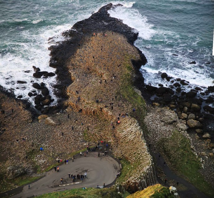
So why is it special?  There’s actually nothing else like it.  A now uninhabited island with a continuous occupation that started over 1,500 years ago, beautifully preserved, easily accessed and in a spectacular location.

I had been trying on and off for a while to get onto the island but it just never happened. During an unusual warm spell in late May I tried again. The Gods were smiling this time and on a bright blue Thursday I boarded the An Breandàn for the short trip across the channel from Kilrush.  Irene told me that the boat was named for her father and it is no coincidence that Breandàn is also the patron saint of the sea.

IG3C6864

Boarding the ferry to Scattery

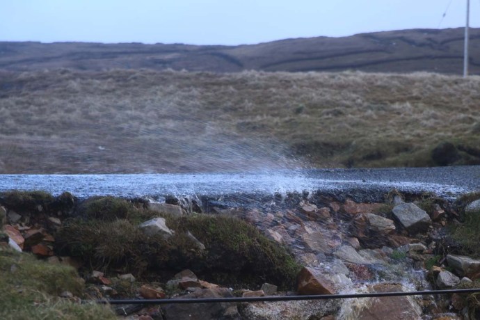
Actually the most time consuming part of the journey was in the lock at the entrance to the Marina. It was fascinating to see the water rush in as the gates opened to maintain the level in the Marina

IG3C7484

Water enters the lock

IG3C6919

Irene Hamilton, owner of the ferry company chats to patrons.

Once through the lock you see the island and its signature Round Tower rapidly approach you and in less than 15 minutes you are there. We were well looked after by  the efficient and friendly crew which included Irene’s sister Martina.  Irene was a mavellous host spending much of the time, when she wasn’t performing seafaring duties, chatting with patrons and and answering questions or helping with family photos or making cups of tea.

IG3C6922

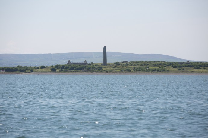
Approaching the island.  The Round Tower dominates.

IG3C6968

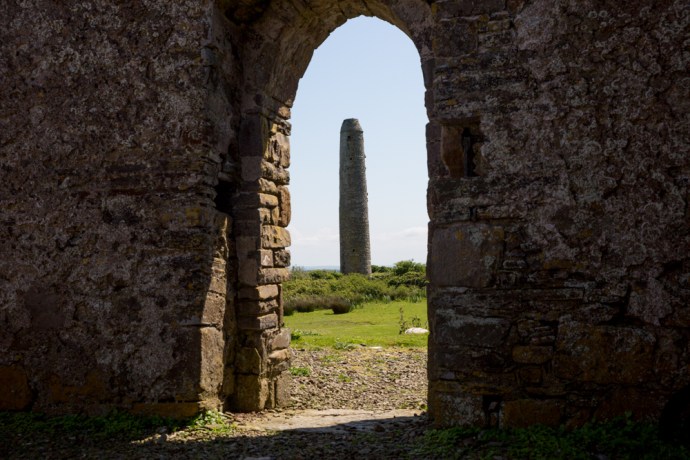
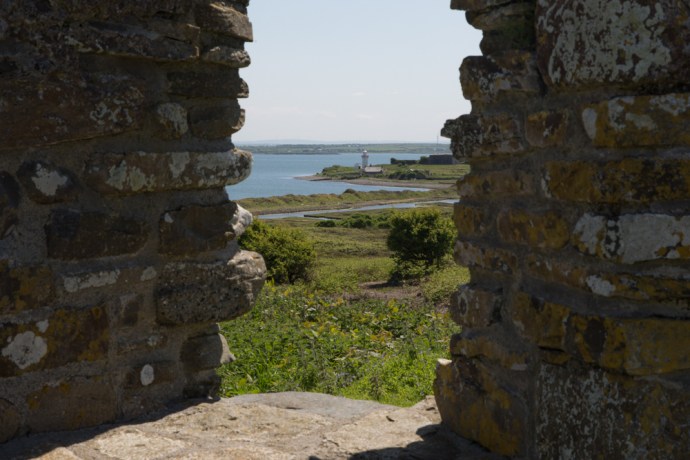
The view from the pier,   The white cottage on the left is the Visitor Centre, Keane’s Castle is in the centre and the Round Tower can be seen in the distance.

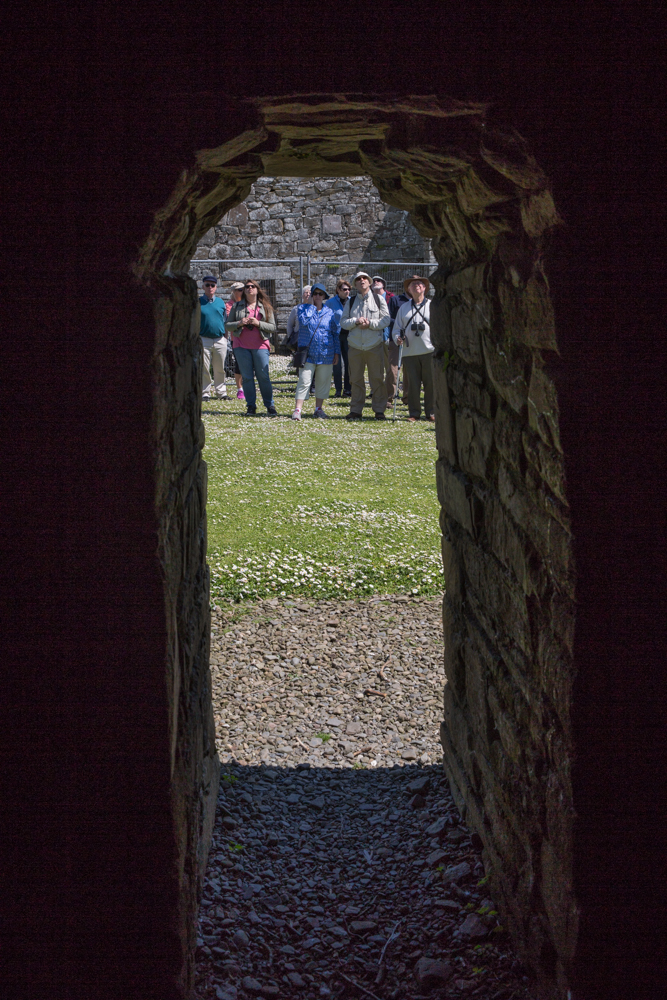
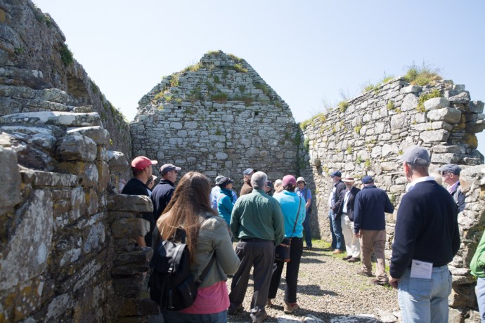
When we arrived we were handed over to  Michael who acted as our guide. The guides are provided by OPW who manage the island.  They also maintain a small visitor centre.  The tour is roughly an hour and you visit all the monastic and archaeological sites with the exception of the lighthouse and the Battery.  This was certainly worth it as Michael has a wealth of background knowledge that fleshed out the story.   Next time however I will explore it on my own but I would certainly recommend the tour as a first time experience.  And anyway it’s included in the price of the ticket.

IG3C7004

The guided tour begins

The story of Scattery starts with the birth of St Senan, in 488AD in Molougha, a townland about 5 km from Kilrush in Co Clare. After a life of religious study including time in Rome he set up a monastery on Inis Cathaig in 532AD.  This is the original Irish name and over time it became anglicised as Scattery.  The name relates to the presence of a monster known as the  “The Cathach” which was said to inhabit the island.  On Senan’s arrival he apparently faced the monster and ordered it, in the name of the Trinity, to depart. Such was Senan’s power that The Cathach obeyed and retreated to Doolough Lake at the foot of Mount Callan.

Little is known of Senan’s life or life under him in the monastery.  Many miracles are attributed to him however and his grave has continued to hold a sacred place among the people of West Clare and beyond. The grave is supposed to be the site of miraculous cures.  Stones from St. Senan’s Bed were regarded as relics and a protection against diseases and especially drowning.  Water from St Senan’s Well had restorative powers.

We do know his rule on the monastery was austere and women were banned from even setting foot on the island.  St Senan died in 544, but it would appear that the monastery continued unimpeded until the arrival of the Vikings in Ireland in 795.  Scattery which lay on their route to Limerick was sacked between 816 and 835, being severely damaged. In 968 the Vikings were expelled from Limerick by Brian Boru and retreated to Scattery. Boru however pursued them and three years later the island was raided with up to 800 people being slaughtered.

In 1057 the Vikings had another go with the Dublin Danes plundering the island. Then again in 1101 Magnus, king of Norway attacked. The Normans arrived in 1176 and this led to an attack by William Howell, not even sparing the churches.  By 1189 the last Bishop of Scattery had died and the Diocese of Scattery was abolished. The English  now took possession of the island.  The end came however following the 1537 introduction of  the Suppression of the Monastries Act by Henry VIII.

Phew! That is some story.  It seems to have been touched by every major historical event that Ireland experienced.  There are many reminders of this tortured time in the ruins that can be seen on Scattery.  Churches that date back as far as the 8th century, the round tower built between 10th and 12th century,  St Senan’s well,  St Senan’s Bed.  I found this all totally absorbing.  Come with me on a virtual tour.

IG3C7082

St Mary’s Cathedral and Oratory.  Built in 8th Century and added to until the 15th century. The Round Tower in the distance.

IG3C7085

The eastern window of the Cathedral.  The carved stone head is said to be St Senan.

IG3C7104

View of the Cathedral from the west.

IG3C7165

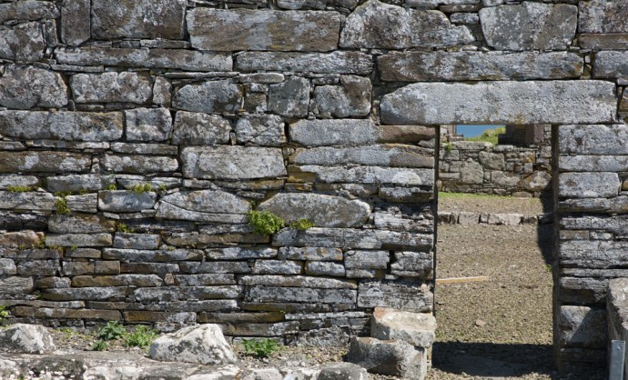
Western doorway of the cathedral.  Note the tapered shape of the door under the heavy lintel.  The stone to the left is thought to be a balaun stone.

IG3C7217

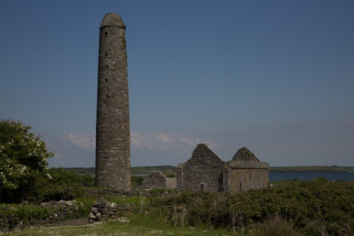
A distant view of the Round Tower and the Cathedral.

IG3C7096

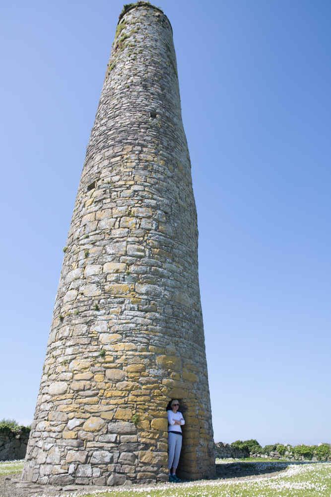
The Round Tower built between 8th and 10th Century. Note the unique doorway at ground level

IG3C7141

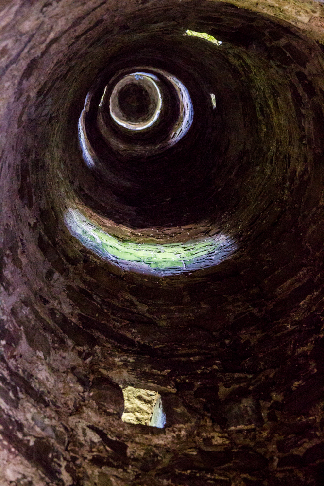
View from inside the Round Tower

IG3C7146

The Round Tower doorway.  Note the thick walls; over 1 metre.

IG3C7237

St Senan’s Well. During a drought St Senan prayed for water and an angel guided him to this spot.  The Sanit plunged his staff into the ground and water sprung forth.  


IG3C7166

Distant view of Cnoc an Aingeal (Hill of the Angel), One of the earliest surviving churches built on the site where Senan set foot on the island.


IG3C7188

Remaining early wall of the church on Cnoc an Aingeal.

IG3C7257

St Senan’s Church.  12th Century Romanesque style

IG3C7292

St Senan’s Bed, a small church built over the grave of St Senan.  The iron bar is supposedly designed to keep women from walking in.  Women who entered according to tradition will be cursed

IG3C7262

View of the Round Tower from the entrance to St Senans Church

IG3C7280

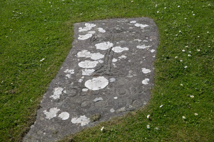
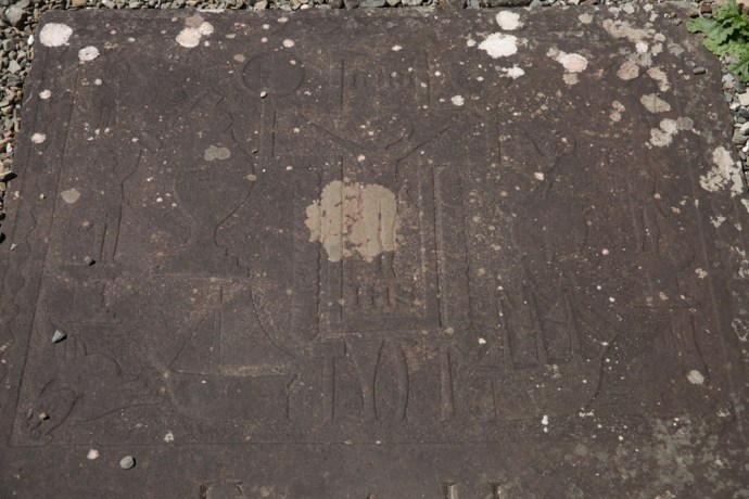
A stone table found near St Senans Church.  Thought to be a medieval grave slab carved with a beautiful celtic cross and with an inscription saying Or Do Moenach Aite Mogroin. (Pray to Moenach the teacher of Mogroin).

IG3C6999

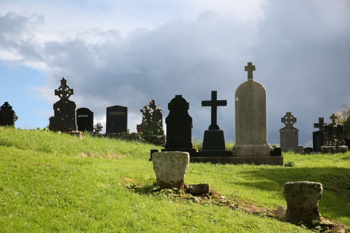
Teampall Na Marbh (Church of the Dead). Built 14th and 15th Century.

IG3C7037

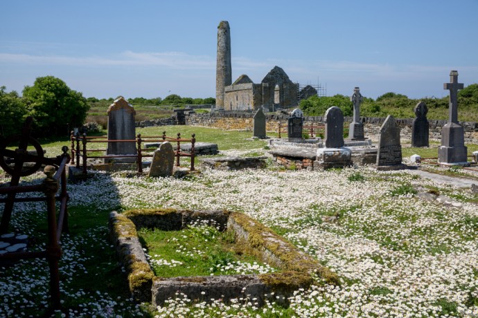
View across the graveyard of the Church of the Dead towards Cathedral and Tower

IG3C7032

Modern graves at the Church of the Dead

IG3C7449

The graveyard at the Church of the Dead continues to be used for burials.

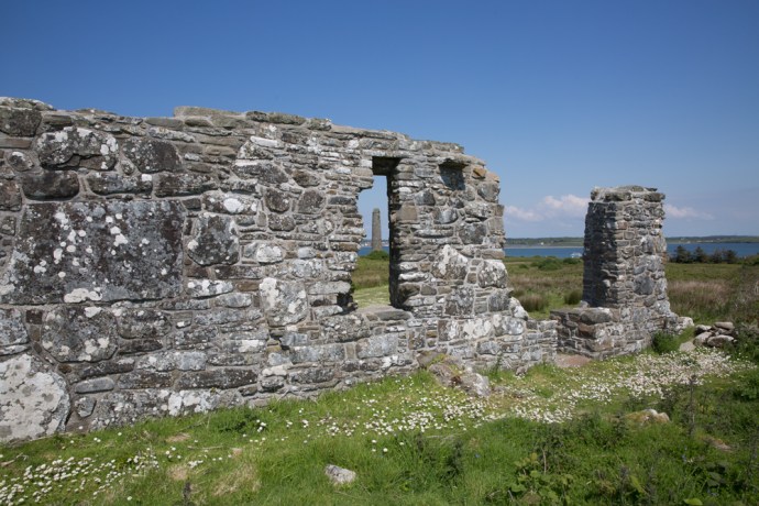
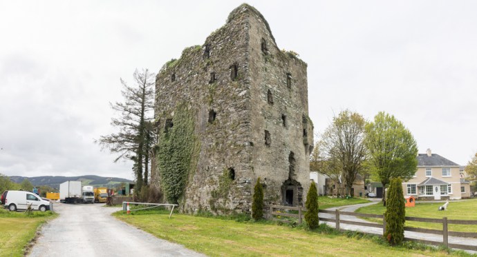
But the island’s story did not end with Henry.  Its strategic position meant it was always in the centre of events.  The ruins of Keane’s Castle, a tower house constructed in the late 1500s can be seen at the pier.  The driver at this time was the invasion by the Spanish Armada and the Irish Rebellions which threatened English rule. Remains of gun installations are evident.

IG3C7477-Pano

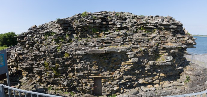
The ruins of Keane’s Castle, a Tower House built in the late 1500s

The next phase of activity on Scattery though did not begin until the end of the 18th century. The French supported the Irish Rebellion in 1798 and in 1814 the impressive Artillery Battery was built by the English as part of the extensive defenses erected on the west coast of Ireland. Unfortunately I did not get to visit this time.  Or the lighthouse which was built later in the 19th Century.

IG3C7176

View of the lighthouse and Arillery Battery from Cnoc an Aingeal

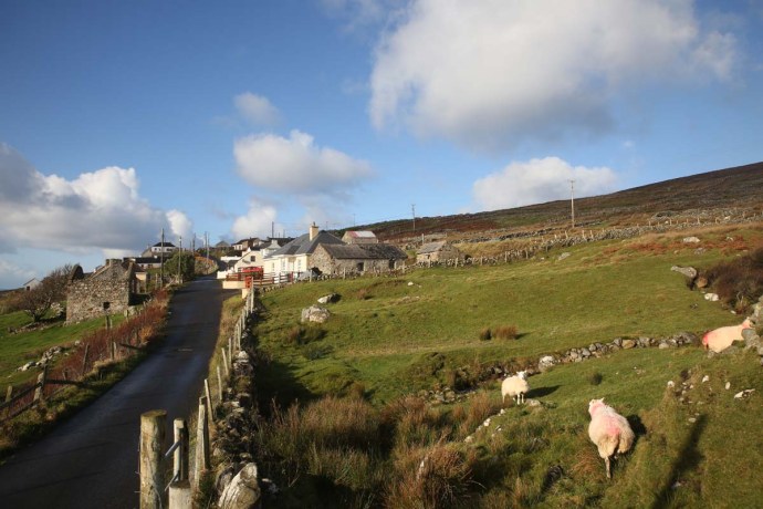
In the early part of the 19th century secular settlement of the island picked up with the construction of a village to house families of river pilots who were based there.  This was when Irene’s descendants came.  The island replaced Kilbaha as the pilots base.  Considerably less rowing of the currachs was required now to reach the ships.

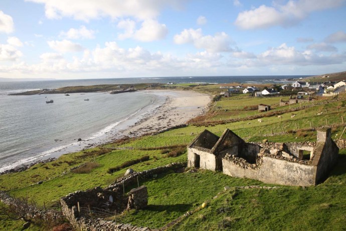
By 1881 the population had reached its maximum of 140 people.  Most of the residents lived in a small area known as ‘The Street’.   Many of these structures still remain and though boarded off  from visitors the closely spaced buildings give us a real feel for what was a comfortable and prosperous community until its eventual demise.

IG3C7342

The Street.  The village that housed pilots and their families from the early 1800s

IG3C7362

The Street.  Another view

Through the 20th century the population continued to decline especially after the pilots were transferred to the mainland in 1954. The last two residents eventually left the island in 1978.  This fact somehow puts the whole story of the island into context.  Its settlement is still in living memory.

There are many reminders of this time aside from the ruins of  The Street and elsewhere.  Many of the gravestones at Tempall Na Marbh, which although being  the youngest of the churches on the island  (14th or 15th century), are beautifully preserved.  Many date from pre-famine time and contain symbolic representations that not only represent religious iconography but tell the story of residents lives.  Though the church ceased to be operative centuries ago many descendants chose to be buried there and they still do today.

IG3C7438

Beautifully engraved gravestone at Church of the Dead.  Dating from 1828

IG3C7058

Engraved symbolic representations on a grave stone including images of a three masted ship and a hooker and perhaps shipwright’s tools.  Presumably the deceased was a mariner.

Following the end of settlement the island lay empty for many years,  This could have been the end of the story as the island eventually passed into the hands of a developer with grand plans for a marina.  Luckily this came to naught and the island was eventually sold to a Belgian group. We owe an enormous debt of gratitude to a group of Kilrush residents who pushed hard to regain ownership and ultimately bought the island back.  These residents still own the island and they ceded management to the State.

That is a great outcome.  It is not hard to imagine that in years to come Scattery will become one the essential Irish monastery sites to visit; right up there with Glendalough and Clonmacnoise.

Put it on your agenda for your next visit.

Categories: My Journey, Real Ireland | Tags: , , , , , , , , , , , , , , , , , , , , , | 3 Comments

Backyard archaeology. Right under our feet. Caherush, Co Clare.

I have spent a lot of my time traipsing around the country exploring archaeological treasures. Ring forts, portal tombs, standing stones, castles, sile-na-gigs, you name it.   I have photographed them and blogged about them. In all that time though I completely forgot to document the archaeology of my own back yard. And I mean literally my own backyard.

In January 2014 Clare, along with much of the west coast of Ireland, was struck with a number of ferocious storm that destroyed beaches and did massive damage to seaside communities. This happened four months before I arrived but the effects can still be seen today.   Hardest hit were places like Lahinch, White Strand, Spanish Point, Quilty, Seafield Pier, Doonbeg, Kilkeee, Kilbaha and Carrigaholt.

In fact the house at Caherush, that was to become mine, was hit hard and inundated, with the then occupants having to be evacuated.

The massive high tides and waves, while doing such obvious damage also uncovered some really interesting things that were previously unknown. For example near Spiddal a ‘petrified’ forest of ancient bog oak was laid bare and, closer to home, a peat layer now covered again was exposed in the bay at Caherush.

This blog is about what was found in the backyard of my cottage after the gravel was stripped away by the waves.  Evidence of long since gone farm buildings was uncovered. A number of different types of paving in close proximity were revealed and these appear to represent the floors of old farm buildings. The site covers 10m x 4m.

IG3C5846

Paving of old farm buildings in the backyard of the cottage at Caherush.

There are cobblestones, setts and flagging, each belonging to a building with a different function.  The original buildings would have been aligned north south. At the southern end an area of cobblestone paving was revealed.

IG3C5852

Cobblestone floor of an old stable.

Cobblestones are one of the earliest forms of paving, the term first being used for roadways in the 15th century in England. The use of cobbles though actually started with the Romans around 250AD. True cobblestones, are small, natural stones with edges smoothed by water, either by the ocean or rivers.  These undressed stones, or cobbles, are often of a flattened egg-shape and were used in their natural state without being worked in any way.  The stones are carefully selected and laid in sand pointy end down and were packed tightly together to provide a relatively smooth and durable surface. This construction has excellent drainage and so they were much longer lasting than the alternative of the time which was dirt. They would also have been used frequently in stables which it is believed was the case here.  A lot of thought went into selecting stones of similar size and shape and in aligning them. It is amazing that it has survived.

IG3C5863

Detail view of the cobblestone paving

IG3C5872

Typical cobblestones selected to be of similar shape and dimensions

Cobblestones went out of favour in the early 1700s and were replaced with setts which are worked into rectangular shapes but still laid the same way. These are actually what people would be most likely to refer to as cobblestone paving now.

So, there is no way of knowing how old this floor is as the tradition of using cobbles may have continued on farms much longer than their use in roadways, especially near the sea. But it could conceivably be pre 18th century,

Next to the cobbles is an area of large irregular slate flagging probably much more recent and representing an access way between the stable and the building to the north. Adjacent to this slate is a beautifully preserved shallow drainage trough made from sandstone setts aligned east west in the direction of drainage. Immediately north of this is a level area of setts in the same rock type and apparently of the same vintage, aligned north south. This area is believed to have housed cattle who would have stood on the level area facing north, which would have enabled the trough to catch their effluent and drain it away. Clever really.

IG3C5883

Cattle shed floor looking from the west.  The drainage trough is in the centre and the area where the cattle stood on the left

IG3C5887

View of cattle shed site from the east.

And then north of this is an area of large flags of Liscannor stone. Mikey Talty who was born in the cottage 80-odd years ago remembers this as a piggery, though he had no recollection of other structures where the cobbles and setts are. The north wall of the piggery had a doorway and this can be seen now filled in in the same style as the surrounding stone wall beneath a lovely stone lintel.

IG3C5854

Piggery floor.  Infilled doorway can be seen.

IG3C5856

Close up of infilled doorway

So there was continued usage of this site to house animals with evidence suggesting the possibility that it may go back over three hundred years.

I think that’s cool. And in my back yard too.

Disclaimer: These conclusions are my own and based on my own observations as well as the recollections of the Talty family. I am not an archaeologist but if anyone out there has specific knowledge of the use of cobbles in farm buildings and their age I would love to hear from you.

Categories: My Journey, Real Ireland | Tags: , , , , , , , , , , , , , , , , , , , , , , , , | 4 Comments

Castle Gan Ainm. A castle in your front yard? Only in Ireland.

How would you like a castle in your front yard?  Well in Ireland you can have one.  They say a man’s home is his castle.  Or should that be a man’s castle is in his home.

IG3C5311-Pano

Just imagine the things you could do with your very own castle.  Like, use it to store your ride-on mower or maybe as a cubby-house for the kids.

IG3C5346

A home for the ride-on


I came across this one recently.  It is just on the outskirts of Liscarroll in Co Cork, which of course has its own Castle that dominates the village.  I could not find a name for this one though, so hence I have christened it Castle Gan Ainm, but it is just like the many hundreds of Tower Houses you find all over Ireland.

This one though is literally in the front yard of a farmer’s house.

It is in surprisingly good condition really and many of the features of such houses are preserved.  For example there is a chute from what would have been the garderobe (fancy name for medieval toilet – comes from the cry ‘garde robe’ made as a warning to those below, before effluent was unceremoniously tipped onto the street).  There are also a few modern additions such as the ‘rooftop garden’ comprising, at this time of the year, gorse in full bloom.

IG3C5368

IG3C5326

Chute for waste products from the ‘gardebrobe’

IG3C5343

A rooftop garden

And of course the resident border collie. The Keeper of the Keep?

IG3C5352

The Keeper of the Keep


Categories: My Journey, Real Ireland | Tags: , , , , , , , , | Leave a comment

The Long Room, Trinity College Library. A Bibliophile’s Heaven.

Most of my readers will not be aware that aside from Irish music and photography which I combine in my blog, another of my other passions is old books. That makes me a bibliophile. If you are on the same wavelength as me then you can understand the feeling that you get when you visit the Old Library at Trinity College in Dublin.  It’s like you have been given early access to the Pearly Gates. Even if you aren’t into books it remains one of the most beautiful rooms in the world and you should see it anyway.

IG3C4151

The Long Room, Old Library.

The Trinity College library is huge, located in a number of buildings both on and off campus. The Old Library is located in Thomas Burgh’s architectural masterpiece ,a building which dominates the Trinity landscape.

IG3C4106

The grounds of Trinity College.  The Old Library is on the right.

It was founded along with the University in 1592 and 70 years later was presented by Vice Chancellor and benefactor, Henry Jones, with its most famous accession, the Book of Kells. In 1656 the Archbishop of Armagh, James Ussher, bequeathed his valuable library, comprising several thousand printed books and manuscripts, to the Library.  This forms the core of the remarkable collection of 200,000 of the oldest books now housed in what is known as the Long Room.

This 65 metre long chamber was built between 1712 and 1732. Initially it had a flat ceiling and books on only one level. In 1860 to accommodate the ever expanding collection the roof was raised and a second level of shelving added along with a stunning curved ceiling.

IG3C4132

Up until 1860 there was only one level with a flat ceiling

IG3C4246

The second level and curved ceiling

Rich wood paneling, wrought iron staircases, giant frosted windows providing a gorgeous filtered light that gives the books a golden glow all add to the ambiance of what is a very special place.

IG3C4127

A remarkable space

IG3C4266

Stairway to Upper Level

IG3C4272

Lots of natural light

The books are housed in a series of double sided shelves labelled A to V on the right side and AA to VV on the left. Interestingly J and JJ are missing as this letter was only added to the English alphabet around 1630. The individual shelves are labelled a to o or aa to oo (again j missing) from the ground up and then individual books are numbered from 1 left to right. This gives each book a unique location number for example, DD m 5. A surprisingly effective pre Dewey-system ifor finding a book

IG3C4212

Cataloging system using letters and numbers

The Long Room is lined with marble busts of authors, philosophers and college benefactors. All white men by the way. Fourteen of the busts are by the famous sculptor Peter Scheemakers.

IG3C4243

Busts line the hall

IG3C4154

IG3C4209

Of course the Library is best known for the Book of Kells (of which two copies are on display) in the attached museum but other prized acquisitions are on display in the Long Room. There is one of the last remaining copies of the 1916 Proclamation of the Irish Republic, read by Patrick Pearse near the General Post Office on 24 April 1916. It was much bigger than I thought.

IG3C4341

A copy of the 1916 Proclamation

The beautiful “Brian Boru harp” is also housed here. This instrument is the oldest of its kind in Ireland dating back to the 15th century. The harp is made out of oak and willow, beautifully carved, and includes 29 brass strings (originally 30).

IG3C4167

The Brian Boru harp

The books themselves are are of course the centerpiece. They are beautifully bound. Mostly of course leather and vellum. Sometimes bindings are works of art themselves. Many are tattered, reflecting years of loving use. Unfortunately you can’t get up close but most books that I could read the titles of are of course in Latin, the language of scholars of the day, and many are apparently religious tracts. But significant proportion I noticed were in English. Shelves full of books on medicine for example caught my attention.

IG3C4277

Books on medicine

IG3C4294

Sometimes a little tape is required

IG3C4330

Ridges characteristic of cord-bound books

IG3C4238

A well used vellum bound set of Works of Andrea Gallandi an Italian scholar who died in 1780

IG3C4326

Bindings of many colours display the bookbinder’s art on this early Bible

IG3C4235

Original editions of works by  Aldrovandus, an Italian naturalist, the father of Natural History, who died in 1605

As a collector, familiar with the value of rare books one can only speculate on the value of such a unique collection and I would suggest that many of the books would be unobtainable. The beauty of them being here and not in a private collection is of course that you could access it if you needed to.  Libraries have adapted to the digital age and surprisingly still remain very popular. The death of the book is wildly exaggerated. Long live the book.

Categories: My Journey, Real Ireland | Tags: , , , , , , , , , , , , , , , , , , , , , , , , | 4 Comments

The Hunt comes to Cree in County Clare

Cree (or sometimes spelt Creegh) is a small village in West Clare. Not much normally happens in Cree but this sunny Sunday afternoon in late October the place was abuzz. Every parking spot was taken up with horse floats and four wheel drives. Walsh’s Bar filled up quickly and jodhpurs, jackets and boots were de rigeur. It was the first event of the season for the County Clare Hunt and Cree was the proud host.

IG3C9966

Horse transports wherever you look

IG3C0040

The main street of Cree and Walsh’s Bar

Hunting (or Fox Hunting as it is probably more widely known) was banned in Scotland in 2002 and England and Wales in 2005 but remains legal and very popular in Ireland (including Northern Ireland) and many other countries such as Australia, Canada, France and Italy. The fox was in fact introduced into Australia for fox hunting and has become one of the country’s worst pests having quite a preference for native marsupials.

The Clare Hunt is one of close to 50 registered clubs in Ireland, each with their own pack of Foxhounds.

Records of hunting with hounds go back to ancient times and is recorded in myths and legends of Fionn mac Cumhaill and the Fianna.  The pursuit was continued by the Norman conquerors and then the Anglo-Irish Protestant gentry. During the Famine in the 19th Century there was bitter resentment and agitation against the landlord elite and the fox hunting became a symbol of British oppression in the eyes of many Irish nationalists. Times change. It is no longer an elite pursuit. Today as many as 300,000 people from all walks of life participate in the activity every year, in some way, in Ireland.

The Hunt at Cree has been the opening event of the season in Clare for the last 20 years. This year 60 horses took part with riders ranging in age from early teens to 70 years. In some recent years as many as 120 have joined.  At least half a dozen have participated in every Cree hunt.  Many riders are well seasoned in all forms of equestrianism and see the hunt as a social activity, a run for the horses and a break away from the stress and discipline of the more formal events such as dressage or three day events. There is no winner and no competitive aspect to it.

I had been told of the event by Grainne, a musician friend with strong connections to this part of Clare. She thought I might like to chronicle and photograph it. I surely would.  And Grainne’s kind invitation set the tone for the day as people could not have been more welcoming.

So from around midday horses and floats began arriving, with their owners and onlookers milling around or grooming their horses in anticipation, until the arrival of the hounds.

IG3C0042

Ready and waiting

IG3C9941

All set

Cree 52

Quite a handful

IG3C0086

Not long to go

IG3C0123

Anticipation

The hounds are kennelled, managed and trained by the Hunt Master on behalf of the club.  At the appointed time the alert and eager dogs are released from their purpose- built transportation. There is excited pandemonium until the Hunt Master’s horn brings them to heel.  Master and hounds now lead the pack away. The riders fall in behind heading off at a trot not to return to Cree until sunset.

IG3C0146

The horn is sounded

IG3C0175

The dogs set off

IG3C0212

And the riders follow


IG3C0246

At quite a trot


That could have been it and the end of my day but the unexpected often happens in Ireland and I was lucky enough to bump into Dympna.  She told me that she and husband Paul had a young horse, Masie, running in the event for the first time. As they had passed their riding days she would be ridden by young equestrian enthusiast, Aoife.  You could feel the sense of anticipation as to how she would go.

IG3C0135

Dympna with a friend wait for the Hunt to start.

IG3C0032

Masie, ridden by Aoife. Warming up.

I got talking to Dympna. They had been coming to the Hunt since the beginning and she offered to take me to some vantage points where I could get some photographs. This surprised me as I had the naïve impression that the riders would follow the hounds on some wild chase zigging and zagging across the countryside.  How could you ever predict where they would be at any given time? On the contrary, the hunt is run over a predetermined course with markers showing where fences should be jumped or streams crossed. It has been the same course for many years.  I asked how the dogs know where to go and how they are controlled. As Dympna explained, the hunt is in the total control of a very experienced Hunt Master, Declan Moran, who has particular charge of the hounds. Indeed he knows each by name. He has a hunting horn and they respond to the different sounds of the horn so in this way he can lead them through the course. If they pick up a scent and run off, he can bring them back.  Skill and training.

So Dympna became my companion for the day and sure enough the first place she directed me to was a perfect vantage point to watch the riders traverse the country, sometimes sticking to roads other times riding along fence lines, and then watch them clear a typical Clare stone wall, metres from a crowd of followers.  All the time led by the hounds and the green jacketed Hunt Master.

IG3C0326

Gathering at the jump

IG3C0307

The hounds go first


Not being a horsey person, it is nevertheless something to behold to see these elegant animals clear effortlessly and confidently these stone barriers. The Irish horse has a reputation for being sure footed and agile and this was certainly on display.

I wondered whether it was difficult to get approval to gallop across the many farms that are encountered. “Not at all” says Dympna. “Farmers are asked for permission a few weeks in advance. There is no problem getting permission. Actually the farmers seem to have pride in the hunt going through their farm”. Dympna says relations are good and “the Hunt will always thank the farmer when passing through”.  The course is walked the following morning with volunteers fixing any fences that need repairs. Given the controversy in some quarters surrounding fox hunting,  Dympna says there has never been any opposition since it started.

The next stop was actually Dympna and Paul’s own farm where with a cup of tea and biscuits we were joined by other members of the family to watch  the Hunt canter past at close range, clearing another fence,  traversing hillsides, riding across open country and crossing streams. Covered in mud now, the soft ground must in places  be heavy going for the horses. Indeed I was regretting my decision not to wear Wellingtons. IG3C0534 IG3C0555


IG3C0776IG3C0785

There was to be a lunch break at Grainne’s family farm, so we drove there to meet up with her and wait for the riders. Food and water was there for the dogs and horses and sandwiches, nibbles and a very welcome hot punch for the participants. All was prepared by members of Grainne’s family; her mum, Marie and Bernie, Claire and Therese were overwhelming with their hospitality.

IG3C0951IG3C0963

IG3C1031IG3C1079IG3C1084

IG3C1147

I was revived by a hot bowl of soup before we headed off for one more stop where the hunt re-joined the road not far from the finish. By now it was getting late and the dogs had been packed up and driven back to Cree (except for one who seemed to be a bit lost)  and, as colour came into the night sky, the remaining riders were happy just to ride two or three abreast walking home at a very leisurely pace.

IG3C1229

Separated from the pack?


IG3C1246

The end of a long day

IG3C1267


IG3C1285

Nearly home Masie


IG3C1294

Towards Cree

It was then I took my leave, dropping Dympna back to Cree and heading off to play some music at nearby Doonbeg.  I later found out that there was more food waiting for them at Cree before the riders washed down their horses, took them home and then headed back to Walsh’s Bar to party the night away.

Many thanks to Dympna, Paul and Grainne and family for their hospitality and for giving me some insight into this perhaps, lesser known part of rural Irish life.  And for somehow organising sunshine for the whole day.


Categories: My Journey, Real Ireland | Tags: , , , , , , , , , , , , , , , , , | Leave a comment

Árainn Mhór Island. Donegal in a Day.

Arguably among the most beautiful counties in Ireland is Donegal. It is a different reality to the postcard bucolic scenery of Kerry or the treeless wilderness of West Clare but it is no less arresting. Visitors come to Donegal for a different experience. For me its the rolling russet-red hilly boglands, granite strewn boulder fields, jagged and sparkling quartzite hills, deep-blue loughs, whitewashed cottages, steep cliffs disappearing into the windswept spray, empty beaches, its fishing villages and maritime heritage, the language, its raw climate and its welcoming people. But Donegal is a big county and it can be hard to get around especially with the limited time many visitors allow in their rush to see everything. But I’ve found somewhere that has all of that and more wrapped up in a 22 square kilometre package that sits just a 15 minute ferry ride off the coast.

This is Árainn Mhór (Arranmore). Donegal’s largest inhabited island it was a complete unknown to me until I got a message from my friend Pauline suggesting we meet there for a day’s exploring.  Just one of those whims that makes Ireland so unpredictably delicious.   She lives on another special island, Achill in Co Mayo, and was looking for a break and, in the fashion of all true island residents, where better to go than another island? So I instantly agreed of course and made the trek from Co Clare arriving on a wet cold morning at the ferry terminal at Burtonport at the appointed time. Well, as is often the way with things in this country, Pauline’s car died so she never made it.  Having lost my guide and companion I headed over anyway with only the vicissitudes of the weather and the narrow winding boreens to lead me on my discovery.

I was captivated from the moment the ferry left Burtonport.  There are two ferries run by two companies.  Known to everyone as the Red or the Blue.  I took the Red. The port was busy enough but only with those who eke a living along the Donegal coast.  Children on the way to school, a delivery of Guinness and a little dinghy loaded with some of life’s other essentials presumably  headed to one of the remote islands.  We picked our way between these small rocky islands dotting the narrow channel.  Many of these islands have houses which I guess for the most part are holiday retreats.  It is only 5 km before we head into the Ferry port at Leabgarrow.  just as the Blue ferry in uncharacteristically, for Ireland, perfect time made space for us at the wharf.

IG3C0058

The Red Ferry heads out from the port of Burtonport

IG3C0020

Essential supplies for life on a Donegal island

IG3C0075

Can’t tell if it’s coming or going.

IG3C0114a

Towards Árainn Mhór

IG3C0142a

IG3C0226a

Approaching Leabgarrow, the ferry terminal at Árainn Mhór

I love this bit. Arriving at a place you’ve never been and know nothing about. Do I turn left or right?  Well I drove off the ferry and headed south and as I did the rain miraculously stopped, the sun burst through and the island glowed. This would be repeated all afternoon. Dazzling sunshine and stormy showers with even a bit of hail and of course wind. I shouldn’t go on about the weather because this is Ireland after all but as I was dead keen to try and capture the island with my camera I was concerned about the light and the rain and my freezing cold hands.  The south coast provides winding roads which snake through the hills giving views of seascapes across to the mainland and passing though hamlets  clinging to the hillsides and strung along the roadway.  Stone-walled paddocks flow down to the rocky shore.

IG3C0341IG3C0366IG3C0389

IG3C0427

As it turned out the island put on quite a light show. With the sun coming and going, the light changed every few minutes. You couldn’t plan; you just had to be ready to catch those fleeting moments.

The dominatingly dark greyscape would disappear and the sea would be lit by a fan of radiating beams streaming under the clouds.

IG3C0362IG3C0347

When the sun shone for those brief moments it would dazzle.  The real colours of the Donegal palette were displayed and intensified. The red and brown grass, deep blue lakes, sparkling rocky outcrops, sinuous black roads,  green paddocks and white cottages. IG3C0522IG3C0531

IG3C0421IG3C0437

Then the wind would be so strong it would blow the mist back over the land or even reverse the flow of rivulets making their way to the sea.

IG3C0637

IG3C1049aaaa

And the rain sweeping in across the ocean would provide interplay with light and dark, waiting for the hand of a skilled painter. The weather was so confused that at one point we had just a beautiful hint of rainbow and an approaching rainstorm juxtaposed.

IG3C1123

The weather can’t make up its mind

IG3C1196

Storms arrive on the east coast

IG3C0831

Storms arrive on the west coast.  Mainland visible in the distance

IG3C0843

Green Island off the west coast of Árainn Mhór

IG3C1189

Looking across towards Errigal

The south coast provides winding roads which snake throught the hill giving views of seascapes across to the mainland and passing though hamlets  clinging to the side of the hill and strung along the roadway.  Stone-walled paddocks flow down to the rocky shore. Then the road turns north and with a few hairpin bends rises to take you to an elevated bog land underlain by granite. That soon changes to quartzite hills – jagged and chaotic. The one lane road meanders across this magic land and you feel anything could happen. And it does.

IG3C0366

IG3C0400

village of Torries at the south of the island

IG3C0506

IG3C0462

Enter a caption

IG3C1232

Quartzite hills

IG3C1211

Bog land and granite

I see a figure in the distance walking in my direction. Due to our respective speeds it takes some time for me to reach him. He is wearing a reflective bright yellow jacket and dark glasses. And carrying a stick. Of course that is not unusual in Ireland but a closer look showed him waving the white stick in front of him. He was blind. This was kilometres from anywhere mind you. He stopped as he heard my car approaching and pulled to the edge of the road. I stopped and greeted him. “Lovely day isn’t it?”  he said. In his defence the sun was shining at that time. “Sure is”. A few more words about the weather and the chance of more rain and then quick as a flash he came back “Where are you from?”. I gave him the potted version and we had chatted briefly. It was clear then that he had had his fill of this outsider and wanted to continue his walk.  I watched him steadily and confidently stride away musing on the inner strength that many have to carry on a normal life especially, or perhaps because of, living in such a remote place.  A truly unexpected encounter.

IG3C0511

Off for a walk

The ‘ring road’ as it is known continues past the island reservoir which has a monumental sculpture immersed in the water and topped by two flags, one of which is the US stars and stripes and the other appears to be an Irish flag but missing the orange. It just looks like someone has cut the orange off.  But if any of my readers know more I’d be grateful to know.    The memorial remembers the terrible hardship of the Hunger in this part of Ireland and how many who were evicted escaped to Beaver Island, of similar size on Lake Michigan in the US. There have historically been strong links continued to this day.

IG3C0624

Memorial to the victims of the Famine and links to Beaver Island.

Every island worth its salt has a lighthouse. The elegant white and red structure was built in 1859 to replace a light first erected in 1798. It is still operational but not attended.  Indeed the former keeper’s residence is now a Bed & Breakfast.  In summer.

IG3C0750

IG3C0772

IG3C0727

The cliffs at Rinrawros Point

IG3C0745

The light and its exposed location at Rinrawros Point, atop jagged cliffs, reminded me of the precarious maritime history of this island. There is a plaque in the ruins of the RNLI building (Royal National Lifeguards Institution) on the south side of the island which chronicles the sea tragedies of the island and it is truly sobering.  From the death of Tom O’Donnell in 1839 and subsequent tragedies, many of which involved multiple loss it has been a rough existence for the Arranmore islanders. And how hard it must have hit some families as names such as Gallagher and O’Donnell which names regularly appear. Worst of all was the Arranmore Disaster when 19 lost their lives in a small boat trying to make it through the passage from Burtonport before the encroaching dark.  As I write this I suddenly realise it was 52 years to the day since this devastating event 9th November 1935. Most of those lost were Gallaghers, many form the one family, with 15 of them returning from working in Scotland.

IG3C1649

arranmproc3[1]

A poignant photo of the funeral for the victims of the Arranmore Disaster

 The fishing industry has been the backbone of life on Árainn Mhór. Which makes it all the sadder to see the abundant evidence everywhere of the decline in its fortunes and the ripple effect this has had on the island.  Just near the ferry port two fishing boats stand by the roadside, decaying reminders of the current circumstances.

IG3C1509

Abandoned fishing boats at Leabgarrow.


Alleged overfishing by island fishermen, paradoxically while EU super-trawlers vacuum up the sea floor beyond the 12 mile limit, Euro intervention and a ban on salmon fishing.  There are now only four fishing boats operating out of the island.  Previously I mentioned the RNLI building, which I thought initially was a church. Closer inspection revealed its real use.   Surrounding it is a sea of stacked lobster pots eerily reminiscent of a graveyard, which it clearly is, and piles of gossamer like netting resting against its walls. On the nearby jetty sits another decaying fishing boat leaning against the pier for support, in one last attempt to stay afloat.  It is very sad to see and testament to a forlorn hope that perhaps there will be better days .

IG3C1599IG3C1608IG3C1620

IG3C1652

With the permanent population continuing to decline to around 500 since its peak in the 1940s (around 1,400), tourism has become the main ‘industry’.  But tourism is seasonal. When I visited in the first week of November there were no hotels open. One large Guest House was for sale.   Early’s Pub, the only restaurant on the island,  only opens on the weekend. The other pub served only toasties (though they were delicious). BnB’s have virtually shut up shop. I was the ONLY overnight visitor on the Island. I am pretty sure of that.  And if it wasn’t for the help of a local resident who was able to contact Annie who kindly opened her BNB for me, I would not have been able to stay on the island.  It is hard to see three months of summer visitors being a viable alternative industry.  If you are going in the off season and I recommend staying at least one night, just arrange accommodation first.

IG3C1493

I’ve spoken of the changing light so I was in high hopes of a classic sunset. While inconveniently placed clouds thwarted me nevertheless the backlighting of orange light provided some remarkable cloudscapes. At time it was like the clouds were alight flames flaring upwards into the night sky and rays of orange directed down to the earth.

IG3C1289

Sunset behind cloud

IG3C1282

Clouds aflame I

IG3C1340

Clouds aflame II

IG3C1337

Glowing thunderheads

And fourteen hours later the display was repeated when I was rewarded for getting up early (7:45 am) with a spectacular sunrise before the clouds descended and killed the show. And then as if to say “Ok.   You’ve had your fun”, rain descended.

IG3C1491IG3C1441

IG3C1459IG3C1451IG3C1435

In all I only spent 24 hours on the island. Enough? Not really. I ‘saw’ everything I suppose but I only got just a little taste of the true feeling of the place.  Pauline, any time you want to try again. I’m up for it.

IG3C0659

IG3C1580

Categories: My Journey, Real Ireland | Tags: , , , , , , , , , , , , , , , , , , , | Leave a comment

Giant Steps

Giants CausewY pAnorama 1

The Giant’s Causeway is on every visitor’s must see list on the island of Ireland. For lots of different reasons. It’s a beautiful place on a beautiful coast, It has mystery and mystique. It is intriguing and enigmatic. That’s why over a million people a year visit.

It is located in Northern Ireland in a part of Antrim known as The Causeway Coast.  I have been there twice in the past year – in January 2017 in the depth of winter and in September. Both times I was gifted with marvellous weather.

For me as a geologist it was like worshipping at a holy shrine. So I thought I would put together a few of my observations from the two trips.  Apologies if this is too dry for you but you can skip the words and just look at the pictures.

So what are we talking about here?

The Causeway is part of an extensive coastline exposing thick basalt flows.  The scenery is nothing short of spectacular with sweeping bays and jagged cliffs stretching as far as the eye can see.


IG3C1241

The Causeway Coast looking west with Giant’s Causeway in the foreground.  

IG3C1248

The coastal path from the Causeway to the Chimney Tops past the Organ Pipes

IG3C1423a

View west showing Causeway and Chimney Tops in the distance.

IG3C9835

Giant’s Causeway is on the right and the Camel Rock on the left.


The Giant’s Causeway is most famous for the spectacular columns, or more correctly ‘columnar jointing’ in the basalt. The origin of the columns has historically caused all sorts of consternation. Our forebears did not believe such regular shapes could be created naturally. So if it wasn’t the work of the Almighty then it must have been Finn McCool. Hence the legend of the Irish Giant constructing the causeway to engage with his counterpart in Scotland, Fin Gall.


Giants Causeway 3

View from the clifftop down onto the Causeway.


IG3C9907IG3C9903IG3C9882

IG3C0976IG3C0961

And he left evidence didn’t he? In his haste to get back to Ireland and escape from his giant nemesis, Finn McCool lost a boot which remains to this day adjacent to the Causeway. There is a more prosaic explanation and I’ll return to this later.


IG3C1038

The Giant’s Boot


The Causeway came to the attention of Science however in the late 17th century and right through the 18th century it was the focus of intense debate as to its origin. Geological science was then in its infancy. Two intensely opposed schools of thought developed. The Vulcanists, who believed the columns were basalt solidified from lava and the Neptunists who said that all rocks including basalt were sedimentary and formed in a great ocean. The Giants Causeway was at the centre of this debate. So it is one of the most significant places in the history of the geological sciences. That debate has long since been resolved in favour of the Vulcanists

We now know, however, that the columns are caused by cooling cracks that developed at the bottom of a lava flow where it was in contact with the cooler rock beneath. As the lava continued to cool these cracks slowly propagated up creating regular, generally six-sided (though they can have from three to seven sides), columns. These regular columns are called colonnades. The hexagonal shapes are caused by the joints tending to be at 120º to each other. At the exposed tops of the flows cooling was more rapid where there was contact with air and water, so the jointing was irregular and blocky. This type of jointing is called entablature. You can see this very clearly in many places especially at the, so called, Organ Pipes


IG3C0876

Regular hexagonal columns

IG3C0947a

Columns with 4, 5, 6 or 7 sides.

IG3C1130a

Columnar jointing


IG3C1117

Spectacular columns at the Organ Pipes

If you look closer at the columns you will see that in addition to the regular vertical joints that create the columns there is also another set of sub horizontal joints which slices each column into regular segments. These were created by the release of stress during contraction within the columns.


IG3C0989

Horizontal jointing


The really intriguing thing is that when these columns break along thee horizontal joints to form the rock platforms they are in fact ont horizontal.  Usually they are either  beautifully concave or convex and the segments fit perfectly together in a ball and socket arrangement. The concave joints are easily spotted on the rock platform as they retain pools of water.


IG3C9908

IG3C9880

Detail of column surfaces.  water collects on convex surfaces


The columns make an impressive display whether on the rock platforms or in the cliffs.  There is a formation at the eastern end known as the Chimney Tops. If the illustration attached from an 1888 book is accurate, then the chimneys are considerably smaller than they were in the 19th century.   I suggest you go and see them before they disappear.


IG3C1229

Chimney Tops 2017


Chimney-Tops-Giants-Causeway

Chimney Tops 1888


It is easy to see how the Neptunists thought the basalts were of sedimentary origin.  There is a distinct layering which could be mistaken for sedimentary banding. Of course it represents different lava flows.  particularly confusing is a distinctive orange red layer in the middle of the cliff.  It is known as an Interbasaltic Formation; a laterite horizon, and is caused by the basalts below it being exposed to weathering for a considerable time before the upper series of basalt flows were deposited. It also suggest a warmer climate at the time as laterites require tropical conditions to develop. It is composed mainly of clays and is rich in iron and aluminium (most other elements were leached out) and has been mined for these ores elsewhere in Antrim.


IG3C9965

Layering in basalt flows

IG3C1232a

Interbasaltic laterite


IG3C1171

Laterite in detail


Within this laterite hori\on you can see relicts of the original basalt as paler partially weathered rock. There are also some excellent examples of preserved circular structures representing earlier spheroidal weathering within the normal basalt. This is caused by water percolating down vertical and horizontal cracks eventually creating rounded blocks. It is also known as ‘onion skin’ weathering.

Oh I forgot.  Finn’s boot.  It’s actually a glacial erratic, deposited by a retreating glacier at the end of the last Ice Age (about 10,000 years ago). Much more boring explanation.


IG3C1045

Giant’s boot.  Glacial erratic


I know I’ve gone on about the rocks but the spirit of the place is palpable.  The only word I can think of is Romance,.

IG3C9962IG3C9909

Romance and Rocks.  What a combination.


Categories: My Journey, Real Ireland | Tags: , , , , , , , , , , , , , , , , , | Leave a comment

Strokestown Park House. A Living Museum.

I love when I visit a place for one reason (usually music) and discover something totally unexpected. Such was the case with Strokestown in Co Roscommon. I had no reason to expect anything other than long days and nights in one or many of the quaint pubs playing music and sampling the odd Jamesons.

It turns out Strokestown, a planned town, has a pivotal and fascinating history. In the centre of the town is Strokestown Park House, the ancestral home of the Mahon family.


IG3C6230

Strokestown Park House

You can’t help but notice the wide avenue that leads to the narrow gate to the grounds.  Aside from O’Connell Street in Dublin, it is the widest street in Ireland. One gets the impression that lined as it is with imposing buildings and Georgian terraces it was meant to create an aura of wealth and prosperity befitting the status of the British landowner; so as they drove the carriage down the avenue his friends would be suitably impressed.  The true state  of the people hidden in the side streets.

IG3C6279

The gateway to Strokestown House in the distance.

IG3C6283

Public buildings.  There’s room to park a bus rear to kerb.

But the family and the name Strokestown has a darker side.  It is now mostly remembered for its connection to the Famine, evictions and land clearances.  That story is told in the Famine Museum attached to the house (which is itself now a museum)  and is an extraordinary one.

The house is a time capsule. The Georgian Palladian style of its architecture reflects the obsession with symmetry at the time and the desire to make the house look bigger than it was. The two wings were largely cosmetic with stables and storage and services. All the living areas were in the main two story house.

IG3C6238

Georgian Palladian architecture.  The central building is the main residence.  To the left are the kitchen and storerooms and to the right the stables.

Built in 1660 the original owner, Captain Nicholas Mahon, was given lands as reward for his exploits with the forces of Cromwell in taking Ireland. The family did well and by the 1840s had an estate of 11,000 acres. An arranged marriage to another prominent British family, the Pakenhams, led to a combined land holding of 30,000 acres spread through Roscommon,.

During the 1700s and into the 1800s Strokestown prospered.  However in the1840s when the potato blight and the consequent famine struck hard in Roscommon, the then owner Denis Mahon implemented a programme of large scale evictions.

In one year alone (1847) he evicted 3,000 people. Though the excuse for the land clearance was the inability of the Irish tenants to pay rent it seemed to be part of a grander scheme.  Immediate steps were taken to advertise the land thus made available in places like Scotland, where presumably Protestant tenants would be more reliable. The clearances were accomplished largely by “assisted emigration” in particular to Canada. As many as 50% of the passengers died amid extraordinary cruelty on these Famine ships mostly through cholera and typhoid and this prompted outrage.  It climaxed in the murder of Denis Mahon at the end of 1847.  The culprits, presumed to be disaffected tenants weren’t identified, but it led to swift retribution against any family that might have had a remote connection as a conspirator.   Much material that relates to this period is on display in the Museum.  In particular there are many original letters and documents which illustrate the plight of the people and the heartlessness of the landlords.


IG3C5256a

A list of tenants recommended for relief work, 1846.  The notes in blue provide comments as to whether the person had made an effort to pay their rent.  They were favoured.

IG3C5258a

A petition from Kilbeg tenants to the owners requesting whether they will be given assisted immigration.  Tenants were keen to go to foreign lands but many never made it.

IG3C5262a

A Notice to Quit on Widow Mary Campbell requesting her to vacate the premises.

IG3C5263a

A Civil Bill used where rent was over twelve months in arrears.  The tenants’ annual rent was £11 5s and their arrears were £16.  They were to appear in court to be evicted.

IG3C5270a

A receipt for £2 to Margaret Brice on surrendering her house, land and manure upon eviction.  Note signed with her mark, an x

Following the joining with the Pakenhams their money enabled the family to survive and prosper into the twentieth century. The last remaining resident however  was Olive Pakenham-Mahon who lived in the house until 1981.

She decided in 1979 to move to a nursing home and sold the house and lands to local businessman Jim Callelly.  He just wanted the land but one day he visited the basement of his newly acquired house and discovered a treasure trove of historical documents that spelt out in intimate detail the story of the house and the evictions. This prompted him to retain the house, restore it and set up a museum based on this archive. And thank God he did.

The house now is furnished exactly as Olive left it. Many of the original furniture and artefacts remain but a lot were sold off to enable her to survive. Olive lived in one room by the end (the Drawing Room) and the rest of the house was essentially abandoned.

IG3C5857

The Drawing Room

Visitors are now able to tour the house. What I enjoyed is that lived-in feel. Peeling wallpaper, organised clutter. Pictures exactly where she had left them. Monogramed personal items lying around.  A toy room with original toys used by her children.  A nursery with original clothes hanging behind the door.  A classroom.  A massive and elegant dining room.

IG3C5842

Entrance foyer

IG3C5927

The Master’s bedroom

IG3C5993

The Lady’s bedroom

IG3C5966

The Nursery

IG3C5957

The schoolroom

IG3C5999

The toyroom

IG3C6059

The Dining Room


There is an amazing kitchen with original stoves, furniture and kitchenware. Our guide related the story that Olive had decided the kitchen was too large and wanted it demolished and a smaller modern kitchen built.  The architect was very reticent and came up with a scheme with false walls and ceilings and modern appliances.  The original kitchen was preserved behind these walls.  Jim Callelly had heard a rumor of this and dismantled it to reveal a treasure frozen in time.  Everything was in place and untouched.


IG3C6115

The old Kitchen with its massive range

IG3C6114

IG3C6102

Beautiful original cast iron cooking range

IG3C6085

IG3C6076

Original Strokestown jug


The library is also impressive. A chippendale bookcase said to be one of the best in Ireland. A pecctacular Grandfather clock. Beautiful globes. Certaily a life style very different to that outside these walls.  A classic retreat for the males in the house as was the custom.


IG3C5904

The Library


IG3C5870

Original 17th Century wallpaper lines the walls of the Library


IG3C5901

Rare Irish Chippendale bookcase in the Library


Many magnificent paintings adorn the walls.  One is of  an ancestral relative, General Pakenham who led the British Army in the Famous Battle of New Orleans. We all remember the history as told by Johnny Horton in his 1959 song

In 1814 we took a little trip
Along with Colonel Jackson down the mighty Mississip.
We took a little bacon and we took a little beans
And caught the British running in the town on New Orleans……..

We fired our guns and the British kept a comin’ …..

You know the rest.  The poor General did not survive but was regarded as a bit of a hero back home.


IG3C5844

Portrait of General Edward Packenham hanging in the Foyer


Unfortunately as was the case with many Anglo-Irish families when they came upon hard times many paintings and treasures had to be sold.  We are reminded of this when we see the faded areas of the original 17th century wallpaper where these paintings used to hang.


IG3C6033

Walls of the Dining Room showing faded areas outlining where original pictures hung.


One such painting was a priceless portrait by Bernardi Strozzi of the acclaimed Cremona composer Monteverdi.  The portrait was painted in c1630 and was sold by Olive for £2,000.  A somewhat amateurish copy hangs now in the Drawing Room in its placewhile the original was returned to Venice.


An intriguing feature of the house is the Servant’s tunnel.  Entered from behind the stables it heads under the house exiting at the back door of he kitchen.  Built to ensure deliveries and movement of servants took place with no interaction with the house, it is easily accessed today.


IG3C6159

Servants’ tunnel under the house

IG3C6205

Entrance to the tunnel


Adjacent to the house is a restored walled garden. A large walled garden of around 4 acres.  After a ten year restoration it was opened to the public in 1997 and many of the original features of this pleasure garden have been retained.  There is a croquet lawn and a Summer House, a Lawn Tennis court, a beautiful lily pond, impressive herbaceous borders (the longest in Ireland), a formal rose garden, beautiful manicured hedges and a pergola. lawns and wildflower areas.  I loved it.  But as with the Vandeleur Garden in Clare which I wrote about in a previous blog, the cruel history of the famine sits uneasily with the beauty and bucolic pleasures of this garden.


IG3C5494

Herbaceous borders line the walls

IG3C5505

There are formal and informal pathways


IG3C5531

Croquet Lawn and Summer House

IG3C5542

Detail of Summer house with Autumn foliage


IG3C5510

Beautiful ornamental lily pond

IG3C5525

Secluded pathways

IG3C5559

Perfectly manicured hedges

IG3C5554

Numerous hidden spaces lie behind hedges

Another treasure of the estate is the Woodland.  There is a circular walk through this leafy mossy retreat with huge oak and beech trees and thick undergrowth.   It was first planted in the early 1700’s by Thomas Mahon and some of the original trees still exist. During the 1800’s, to increase the pleasure of the shoot, laurels were planted creating a thick undergrowth.  Eventually it took over but it was sensitively restored in 2011.  The fairies have gone a little overboard though and seem to have occupied nearly every tree.

IG3C5333IG3C5429IG3C5376

IG3C5435


IG3C5402

When old chairs become an art installation.


Truly the house, the museum, the garden and the woodland will keep you occupied for four or five hours.  They will be four or five hours well spent.


Categories: My Journey, Real Ireland | Tags: , , , , , , , , , , , , , | 3 Comments

Ruins and Ruined Dreams. An Abandoned House in Roscommon,

I have talked about abandoned houses in the Irish landscape many times. They are so characteristic, they are part of the DNA imprint of the countryside. Ruins appear to date from many times and reflect the struggles of the Irish as they deal with famine, invaders and economic and social dislocation. Naturally the iconic image is of the castle ruin or the grand manor house, but cottages and farm houses are so much more abundant. I often wonder about the stories behind these buildings. Ruined lives and ruined dreams; or did they find a better life somewhere else.

IG3C3144_1

This is one such house. It lies on the edge of the Kilronan Mountain Bog near Ballyfarnon in north Roscommon. A remote place.  It is close to the Arigna coal mine and perhaps the family living here derived its income from there.  The ruin is intact but blackened walls at the entrance suggest maybe some fire damage at some stage. It is not an old house and the front door is missing a panel so curiosity got the better of me. I walked into a time capsule.  IG3C3115_1

The house is a mess. Largely empty with years of accumulated debris covering the floors. Sheep have been regular visitors.   The rooms are spacious and well suited to a family.  The walls are bare save for a small crucifix over the living room door.  The walls were generally neutral colours but through the peeling paint are bright greens and pinks reflecting changing fashions. The kitchen was bright blue with pink trim.  Scrape away the sediment on the floor  and it reveals a very 60s brightly coloured lino in the main living room.  Definitely not to everyone’s taste but an individual statement.   No personal possessions remain.  Nothing that would give us a sense of who lived here.  Items too large to take though have been left behind.  A television, some chairs, a fridge and stove. All now beyond use.

IG3C3117_1IG3C3123_1IG3C3143_1

IG3C3127_1

Stairs lead to a mezzanine level with two rooms, shelves and some decaying mattresses.  Everything is still there in the bathroom, even the shower curtain and taps.

IG3C3129_1IG3C3130_1IG3C3139_1

I got the sense of a comfortable home. There is central heating and fireplaces in every room; there was insulation in the ceilings and to me it would seem they had the trappings of a good life.

What went wrong and when? Where did they end up? Fortunately we can answer as to when?  A newspaper among the papers strewn on the floor dates from July 1997.  My eyes fell on an article with a headline: “Anna Spices up Wimbledon”.  A sixteen year old Anna Kournikova was at the beginning of her rollercoaster ride in the world of tennis while this Roscommon family grappled with a very uncertain future.

IG3C3124_1

My original thought that the breadwinner worked at the Coal Mine makes sense except that it closed in 1990.  Perhaps they struggled on for another 7 years before finally giving up.

We will never know what makes a family walk away and leave their house.  Leave fridges and stoves and furniture.  Leave curtains.   And head somewhere for a better life.  Unfortunately it has been a huge part of the Irish narrative for nearly two hundred years.

No doubt such events happen in other countries but what is different here is the scale of the dispossession and that the evidence remains for decades perhaps even centuries with these dwellings lying empty and untouched; as if interfering with the ruin would somehow be disrespectful.

So many pages of the Irish Story lie open to us in this way.  However the writing is indistinct and many times illegible and impossible to decipher.

These ruins for me are always a time to pause and think.


Categories: My Journey, Real Ireland | Tags: , , , , , , , , , , , | Leave a comment

An Apology to Turlough O’Carolan

Driving through Keadue in the very north of Co Roscommon, as I was on this crisp, clear Autumn day, you are reminded everywhere of Turlough O’Carolan. There is what seems to be a new sculpture in the main street of this spotless town with a harp at the centre and there is a Heritage Park with monuments to the man. A carved coloured stone with the music for Sí Beag Sí Mór sits in a rotunda that looks out over the village to the Arigna Mountains.  And if you come back in August next year you can attend the 40th O’Carolan Harp Festival.  Though born in Co Meath, the blind harpist and composer lived in and around Keardue/Ballyronan so this is definitely O’Carolan Country.


IG3C2815

The village of Keadue


IG3C2791

Tribute to O’Carolan?  newly installed statue in Keadue.


And just out of the village, there is the Kilronan Cemetery where he was buried. The elaborate entrance proclaims this with a carved stone mounted over the gate.  His grave lies within the family crypt adjacent to the ruins of the Abbey.


IG3C3007

Entrance gate to the Kilronan Cemetery

IG3C3009

Detail of the front gate.

IG3C2999

Kilronan graves

IG3C2984

Kilronan Abbey ruins.


The sun was shining when I visited and of course I had to take a ‘selfie’ of me playing Sí Beag, Sí Mór at the grave site. Now I am not a superstitious person but I swear that as I played the last note a black cloud came from nowhere and filled the sky. The heavens dumped for about three minutes as I retreated to the safety of my car.


IG3C3018

The headstone of the grave for Turlough O’Carolan. 

IG3C3028

Sí Beag, Sí Mór

IG3C3034a

One minute later the heavens dumped.


I get the message, Turlough. I have to admit that a friend warned me not to do it. Now seriously, I’m sure it wasn’t the worst you have heard, but I promise never again.

Sorry.

If you’re in that beautiful part of the world. Go visit. Just don’t play Sí Beag, Sí Mór.

Categories: My Journey, Stories, Trad Irish Music | Tags: , , , , , , , , , , , , , , , , | 4 Comments

Blog at WordPress.com.