Posts Tagged With: history

Dowth, Co Meath. An history time capsule. From megalithic tombs to John Boyle O’Reilly.

dowth-6613

View of Dowth Chapel and Manor, Dowth Castle, Dowth school and the Dowth church 

The picture above I took in July 2019.  I didn’t realise it at the time but in that one photo I captured eight hundred years of history and the Irish struggle.  An history that includes the rise and fall of the great Anglo-Norman families, Oliver Cromwell, J B O’Reilly and the struggle of the Fenians, penal servitude and escape and the diaspora; and as if that wasn’t enough the destruction of a 5,000 year old megalithic treasure. Left to right is the Netterville Chapel, Netterville Manor, Dowth Castle, Dowth school house (the low stone building with the gabled roof) and the ruins of Dowth Church on the far right.  Here’s another view.

dowth-6424

View of Dowth Manor, Dowth Castle and the Dowth church and graveyard

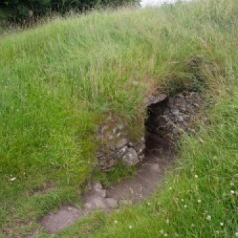
And a couple of hundred metres to the right, too far away to get into the picture, is the Dowth passage tomb.

dowth-6463

Dowth Passage tomb mound viewed from the church.

Let me explain a bit more.  Stay with me and I’ll try and keep it brief.

Dowth in Co Meath, lies near the banks of the Boyne River in the famous Bend of the Boyne, where is the world heritage site of Brú na Bóinne and the passage tombs of Newgrange and Knowth.  As I referred to briefly, there is also a passage tomb at Dowth.  I’ll come back to that, but my story starts with Dowth Castle, the ancestral home of the Netterville family, who were granted the estate in the 13th century.

dowth-6582

Dowth Castle.  Home of the Nettervilles

In 1641 during the civil war, then Viscount Netterville was declared an outlaw for supporting the Confederates and deprived of his estates. Ten years later he was pardoned by Oliver Cromwell.  And then in 1655 another Netterville was imprisoned in Dublin Castle as a traitor but escaped death pleading that he was held by the rebels against his will.

Subsequent Nettervilles displayed all the eccentricities you would expect of these ruling families.  The incumbent Lord built a Manor house in 1780 and moved out of the castle.  It was complete with elaborate gardens, ramparts and walks around the House and Castle.  He built a tea house on top of the passage grave mound and attended mass remotely with the assistance of a telescope focussed on the church.  Unfortunately, the Viscount was also unknowingly complicit in the destruction of the tomb.  With money he donated to excavate the ruins before his death,  members of the Royal Irish Academy in 1849, used, can you believe it, dynamite and destroyed the mound leaving a crater you can still see today. I’d like to think he would have been horrified at what was done.

dowth-

Crater at the top of the Dowth Mound

While we are talking of the Dowth mound, it is not on the tour agenda of Newgrange, but it is worth visiting separately to get a feel for what they may have looked like in the field.  There is no reconstruction here (just destruction it seems!). There were 115 kerbstones of which half are visible.  Fifteen are carved including the spectacular Stone 51, known as the Stone of the Seven Suns. Also surviving are two passage entrances.

dowth-6440

Some of the surviving visible kerbstones at Dowth mound. Stone 51 is the fourth stone from the right.

dowth-6450

Stone 51.  The Stone of the Seven Suns.  

seven-suns

A drawing of Stone 51 by archaeologist, Martin Brennan.  


Back to my story.  In 1826, the property was bequeathed for the construction of an ‘alms house’ for aged women [alms houses are a Christian charitable tradition whereby accommodation is provided for poor, old or indigent people].  The magnificent Victorian Gothic red brick structure was built as part of this endowment in 1877 along with the chapel.   I particularly love the decoration in the brick and over the windows and doors highlighted with blue bricks.

dowth-6597

Part of Dowth Manor Alms House.  Beautiful red brick with details outlined with blue brick and limestone.

I’m not sure how long it lasted as an alms house, but it has had a variety of uses since then in the 20th century.  During the 1960s the house was the headquarters of the Newgrange excavations (hopefully without dynamite this time).  It has been owned by the Hearst Family and was once occupied by a group of Buddhists, and more recently as a venue for weddings and conferences.  It was up for sale in 2015 at €2.25 M.

All that is truly fascinating but for me it is the connection of the property with J B O’Reilly that makes it come alive.

John Boyle O’Reilly was a man of his time.  A charismatic man who in his short life may well have been the best know Irishman across three continents.  He was an Irish hero and made his mark in many fields.

His name was well known to me through his authorship of the novel, Moondyne, an Australian classic, and his involvement in the spectacular Catalpa rescue of Fenian prisoners from Fremantle Jail.  What I didn’t know is anything of his life in Ireland and America, which is littered with monumental achievements.

It was only by accident that I stumbled on the connection.  After inspecting the passage tomb I was drawn to the ruins of a church a little distance across the paddock.  There I discovered a memorial to him at the back of the church. The monument was erected in 1903.

dowth--2

Memorial to John Boyle O’Reilly at the back of the Dowth church.

dowth-6531

J B O’Reilly memorial built 1903

It turns out he was born in the tower house, then occupied by his father, a schoolteacher.  Indeed the school was next door in a low stone building adjoining the tower house. 

dowth-6576

The school house at Dowth attended by John Boyle O’Reilly until he was 11.  His bust and a plaque are on the wall.  

So I brought myself up to speed on his life story.  His achievements are many and his impact profound and there is not space here to cover it all but here are a few highlights from his extraordinary life.

  • Born in 1844 into the middle of the Irish Famine. Being born into privilege he survived.
  • Leaves school aged 11 to take on an apprenticeship as a printer at the local Drogheda newspaper
  • Goes to London at 13 to work as a stenographer
  • Returns to Ireland at 19 and became a soldier in the British Army
  • Soon after he joins the Fenians at the invitation of the IRB and infiltrates the British Army
  • Arrested at 21 and sentenced to death for treason. Commuted to 20 years hard labour because of his youth.
  • At age 23 he and sixty-one other Fenian prisoners sent to Fremantle, Western Australia.
  • At age 24 escapes from Fremantle on a whaling ship. Fakes his own suicide to avoid capture at Mauritius.
  • At age 25 arrives in US via London, on the run. Moves to Boston; works for The Pilot newspaper.
  • At age 31 becomes owner and editor of The Pilot. It becomes second biggest Boston newspaper after the Boston Globe.
  • Becomes a spokesman for Irish immigrants, a well-known poet, orator, sportsman, and activist for political causes.
  • At age 31 helps organise the rescue of six Fenians from Fremantle, again using a whale ship, The Catalpa.
  • Becomes one of Americas foremost poets.
  • At 34 writes Moondyne, a semi-autobiographical novel set in Australia.
  • At 35, acknowledged leader of the “Irish cause”
  • Dies at 44 from an accidental overdose of his wife’s sleeping pills

Wow!  Admired and revered on three continents at the time, his work has been criticised subsequently, especially Moondyne, as presenting degrading portraits of Aborigines and glowing praise for capitalist exploitation by the British empire, with racist overtones.  Yet the novel was a landmark.  It scoffs at hypocrisy, and deals with redemption for the downtrodden and forgotten in society and among other things offers solutions on the Australian penal system, the Irish land question, and America as a model for the future.

So there it is.  A huge part of the story of Ireland reflected in this collection of buildings in a beautiful valley in County Meath.  And to think I could have just driven straight past it.

dowth-6640

Categories: My Journey, Real Ireland | Tags: , , , , , , , , , , , , , , , | 3 Comments

Ireland’s First Copper Mine.  4,500 years of mining history

I have stumbled onto historical mining in a number of places in Ireland in my travels.  Particularly at Allihies and Mizen in West Cork and along the so-called Copper Coast in Waterford.  However, I had no idea of the significance of copper mining in Killarney, and only came across it by chance recently when exploring Killarney National Park’s other delights.

19th Century mining of copper underpinned many fortunes for its British landowners.  In Castletownbere in West Cork,  it was the Puxley’s and Killarney it was the Earls of Kenmare and then the Herberts, who funded their magnificent home at Muckross from their mining wealth.  Ironically the mansion at Muckross was completed in 1843 as the Famine ravaged Ireland.  But the saga of mining in Killarney goes back much further, deep into Neolithic times.

copper-7671

Muckross House built by the Herbert family with money from their mining fortune

copper-7678

Muckross House. Built 1843

When we talk of mining history in Australia, we think back to the first gold rushes in NSW and Victoria, which were in 1851, or Australia’s own copper boom, which started in South Australia in the 1840s. Mining effectively ended Australia’s time as a penal colony and led to an explosion of free immigration.  So it took a bit to wrap my mind around the mining heritage of a country that goes back thousands of years.

Mining has taken place at two locations on the Killarney Lakes, Ross Island and on the Muckross Peninsula.  Mining there reflects human occupancy from the end of the Neolithic Period and the early Bronze Age (2500-1800 BCE) through Christian times (8th Century) to industrialization in the 18th and 19th centuries.

Ross Island is the earliest known site for copper mining in Ireland.  The activity has been dated by the discovery of Beaker pottery by a team from National University of Ireland Galway in 1992.  The so-called Bell Beaker culture is named after the inverted bell-shaped pottery vessels found scattered throughout Western Europe and dated in Ireland from 2500 BCE to 2200 BCE.  This has been confirmed by radiocarbon dating at the site.

b58b979f73b02d15ca6bcc3d894c151c

beaker

Beaker vessel characterstic of the style of the Bell Beaker culture, fragments of which were used to date the Ross Island mining site.  Photo credit: http://curiousireland.ie/the-beaker-people-2500-bc-1700-bc/

The true Bronze Age in Ireland (that is when copper was alloyed with tin or arsenic to manufacture weaponry and tools) started around 2000 BCE.  Prior to this was the ‘Copper Age’ and copper from Ross Island would have been used for daggers or axe heads or other copper objects and was traded widely.  Chemical fingerprinting and lead isotope analysis shows that Ross Island was the only source of copper until 2200 BCE in Ireland. Not only this, but two-thirds of artefacts from Britain before this time show the same signature.  And Ross Island copper is found to be present in artefacts found in Netherlands and Brittany.  After this time other mines from southern Ireland became more important.

So, Ross Island saw the transition from the Neolithic to the Bronze Age.  Frankly, to me as a mining geologist, to be able to stand on the place where the mining took place that underpinned this highly significant transition in human development in Ireland was, for me, a special experience.

The early miners exploited a rich band of oxidized copper ore within the limestone through shallow cave-like excavations, tunnels and chambers, most of which were damaged by subsequent mining.  Some of the surface ‘caves’ are visible today behind a rusting iron fence though the view is unfortunately heavily obscured by vegetation, which has been allowed to grow unchecked.

copper-7953

Bronze Age mining excavation Ross Island

copper-7956

Bronze Age mining Ross Island

copper-7954

Probable Bronze Age mining excavation with later 18th Century stone walls.

These openings were made in the days well before explosives, by lighting fires against the rock face to open fractures and then pounding the walls with stone hammers.  The broken rock was then hand sorted and the separated ore was converted to metal by smelting in pit furnaces.

The last of the first phase of mining from this site is dated at 1700 BCE.  Mining lay dormant for centuries then, but in the early Christian period was a Golden Age of metalworking in Ireland, when such treasures as the Tara Brooch were produced.  Killarney was one of the centers of metallurgical and artisanal skills.  Excavations at Ross Island have found small pit furnaces that date from 700 AD suggesting that ores from here were used to produce metals for the production of  such objects.

Another thousand years passed before the final chapter in the exploitation of the wealth of Killarney copper played out.

This last phase of mining commenced in the early 18th century.  The first attempts at extracting lead in 1707 and then again to work the mine in 1726 failed.  In 1754 Thomas Herbert commenced mining under an arrangement with the then landowner, the Earl of Kenmare.  Mining was difficult due to flooding from proximity to the lake edge and for the next fifty years was sporadic.

I must digress for a moment.  In 1793 Thomas Herbert invited a mining consultant Rudolf Raspe to advise on the mines.  Why do I mention this?  Raspe was German and author of The Fabulous Adventures of the Baron von Munchausen (published in 1785). You might have seen the movie or heard of ‘Munchausen Syndrome’ but I grew up with these fantastical stories read to me by my father. Who would have dreamt of a connection between these far-fetched tales and copper mining in the west of Ireland. Anyway the poor fellow didn’t have such a Fabulous ending dying of scarlet fever a few months later and being buried in an unmarked grave near Muckross.

Meanwhile mining on Muckross Peninsula started in 1749 on the Western Mine and by 1754 the company had raised some £30,000 worth of copper ore, which was shipped to Bristol for smelting.  This closed in 1757 and operations commenced on the Eastern Mine opening for short periods in 1785 and again in 1801.  Operations resumed on the Western Mine in 1795 but these failed due apparently to mismanagement.  Little more was heard of this mine and it was considerably less successful than its neighbour.

copper-7465

Mining spoil at Muckross Mine seen from the lake

copper-7189

Muckross Peninsula.  18th Century smelter building

copper-7187

Inside smelter building showing unusual curve flue.  There were at least three smelting furnaces in the structure.

copper-7198

Muckross Peninsula. Old mine building

But things might have been very different. A dark crystalline mineral was encountered which oxidised to a very bright pink.  It had no copper and so was discarded.  One miner recognised it as the cobalt ore, cobaltite (CoAsS), with its oxidized form, pink erythrite (Co3(AsO4)28H2O).  This man quietly removed twenty tons of this ‘rubbish’ undiscovered.  When the proprietor later realised its value, it was too late.  It had been removed by his helpful employee, or mined as waste and thrown away to expose the copper ore.  Reminds me of the non-recognition of the gold rich Telluride ores in Kalgoorlie in 1893, which for years were used to surface roads, until a way was discovered to extract the gold.  Needless to say, the roads were ripped up.

58023det

Erythrite from Muckross.  Photo credit: Online Mineral Museum

Back to the Ross Mine, which at the beginning of the 19th century had another renaissance. The Ross Island Company obtained a 31 year mining lease from Lord Kenmare in 1804, Work commenced on the Blue Hole on a rich lode of lead and copper. Mining continued until 1810 by which time it had become unprofitable.

copper-7911

Blue Hole Mine open pit

copper-7916

Northern pit Blue Hole Mine. Mining completed 1810

The operation was restarted by the Hibernian Mining Company (1825-9).  Both struggled with the perpetual problem of flooding.  One solution suggested was to drain Lough Leane; this did not go down too well as you can imagine, particularly with the local boatmen.  In the end a large coffer dam was built on the shore and water pumped into it from the mine. Part of the dam is still there.  Bigger and bigger pumps were required and ultimately by 1828 they were unable to deal with the water and the mine closed. Most of the Western Mine area is now flooded as the dam walls have been breached

copper-7925

Eastern coffer dam.

copper-

Part of Western Mines area flooded by breached dam wall on left.

copper-7866

Ross Island.  A walled off limestone cave with steel door.  My hunch it was used as a magazine.

copper-7928

Old shaft near Blue Hole mine

copper-7932

Site of Old Engine House Ross Island Mine

Wandering over the site today does not give a true sense of the scale of mining in the early 19th century.  This map by Thomas Weaver from 1829 shows the fifty or so shafts, underground tunnels and surface buildings from this phase of operations.

new_pa2

Thomas Weaver map of Ross Island mine workings 1829.  Photo credit NUIG.

But mining grew out of favour and conflicted with the rise of tourism to the area.   No more mine leases were granted after 1829 by the Herberts, who by this time had transitioned from mining entrepreneurs to landowners. The area was carefully landscaped, with the infilling of shafts, flooding of the Blue Hole, the demolition of buildings and the planting of trees. Subsequent forest growth has softened the historic footprint of the mining

Mineral exploration is now prohibited in the National Park so the remarkable 4,500 year history of mining here has come to an end.  Public awareness however of this important site is increasing with the creation of a Mining Trail and explanatory signage at the site.  To me, places like this are as important as Glendalough and Ceidi Fields and their preservation is so important.

I am ashamed to say that after five years in Ireland I only discovered this place by accident.  But find it I did, and I will be back there as soon as I can be.


Much of the material for this blog came from the informative website of the National University of Ireland Galway who completed the archaeological study of the historical mining sites in 1992.   http://www.nuigalway.ie/ross_island/.  My thanks and acknowledgement to them.

Categories: My Journey, Real Ireland | Tags: , , , , , , , , , , , , , , , , | Leave a comment

The Puck Fair, Co Kerry. A 400-year old tradition.

Some institutions in Ireland die hard.  One is the Puck Fair.  Held annually in Killorglin in Co Kerry in August, it is surely one of the country’s longest running public events.  As with many of these things though, the written record is scant and it is not clear exactly how old it is.  There is a reference in 1613 to a local landlord, Jenkins Conway, collecting a tax from every animal sold at the ‘August Fair’ and even earlier there is a record from 1603 of King James I granting a charter to the existing fair in Killorglin.  So let’s just say it is well over 400 years old.

puck-6827

The main street of Killorglin is choked for the Puck Fair

Puck derives from the Irish Phoic, meaning He-goat.  Again, when the fair became associated with the goat is also shrouded in mystery.  The story I like tells how in 1808 the British Parliament made it unlawful in Ireland to levy tolls on cattle, horse or sheep fairs.  The landlord of the time lost his income and on the advice of then budding lawyer Daniel O’Connell (yes, that Daniel O’Connor), proclaimed it a ‘goat fair’ and charged his tolls as usual believing it was not covered.  To prove it was indeed a goat fair a Phoic was hoisted on a stage and proclaimed King Puck.

Whatever the truth, a male wild goat is still today crowned King and hoisted in a cage up a tower where he remains for three days before being released back into the wild.  The crowning of the goat though, I have to say, was a disappointment. Conducted on a stage under the tower, with its steel barrier that restricted vision, the goat was held by two burly yellow-coats and surrounded by photographers.  A young schoolgirl, the ‘Queen of the Fair’, placed the crown on its head.  Well, I think that’s what happened.  It was really just set up for the publicity shots, as the audience could see nothing.  Placed in the cage the goat was then hoisted up for all to see, its crown a little shakily slipping below its horns.

puck-7311

Behind that phalanx there is a goat getting crowned

puck-7354

The King of the Fair is hoisted up the tower

puck-7374

King Puck

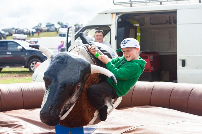
The fair brings out the crowds for a great day out.  There is a horse fair in a nearby field, with all the usual horse-trading that happens.  I happily spent an hour wandering here clicking away.  There was plenty to keep me enthused and bemused.

puck-6811

The horse fair is held in a field adjacent to a ruined church and graveyard

puck-6774

Now that’s style

puck-6756

puck-6733

Like father like son

puck-6714

You have been warned.

puck-6770

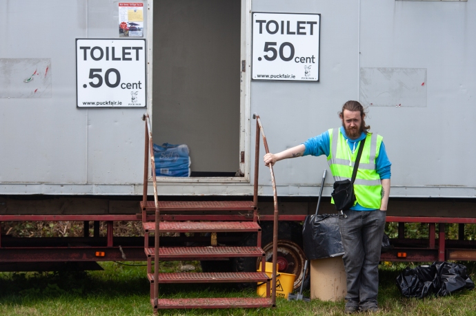
The cheapest pee in town.  Just a half a cent!

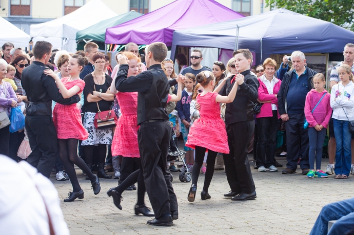
There are rides, a parade and plenty of characters to fill the pubs and the streets. Every vantage point was taken.  The bright sunshine, when I visited in 2015, provided an opportunity for the colleens  to strut the summer fashions. I love the way traditional music is never far away from an Irish event, with entertainment on stage and in teh nearby pubs, dancing in the street or a brush dance in a pub.

puck-6866

The long and the short of it.

puck-7227

A great vantage point

puck-6838

Even manequins are keen to strut their stuff

puck-6927

Dancing in the streets

IMG_6852

Well known piper, Brendan McCreanor, from Co Louth entertains the crowd

puck-7032

puck-7084

Swept away by a brush dance

puck-6764

A chance to dress up

puck-7004

A chance to dress up II

puck-7422

Defying gravity

The Puck Fair is always held on 10, 11 and 12th August so mark it in your calendar.

Categories: My Journey, Real Ireland | Tags: , , , , , , , , , , , | Leave a comment

Scandals & Scoundrels. The Early Days of WA’s Golden Mile.

In a former life I was, for three years, Chief Geologist at the Super Pit,  Australia’s largest gold mine consuming what’s left from undergound mining of Kalgoorlie’s Golden Mile. The richest concentration of gold in the world. Mining has been carried on continuously here since 1893, when gold was first discovered by one Paddy Hannan, from the village of Quin in County Clare.

gm01035

The Golden Mile in 1905.  Photo JJ Dwyer.  WA Museum

The Golden Mile in 2017.  The Super Pit.  Eastern Goldfields Historical Society

Don’t get me wrong, Paddy was not a scoundrel; I’ll talk about those characters in a bit.  Paddy Hannan led a party of three Irishmen that changed the history of Western Australia, starting a rush that populated the desert and rescued a depressed economy.  There are many reminders of the man – Hannan Street, Hannan’s Hotel, Hannan’s Lager (now sadly defunct) and a statue in the main street erected in the 1920s.  Before the name was changed to Kalgoorlie the place was even called Hannan’s.

paddy_hannan

Paddy Hannan, taken in the mid 1920s.  Photo Battye Library WA.


picture1

Hannan Street, Kalgoorlie, Postcard from 1907.  Coll. Bob Singer

picture2

Crowds gather in Hannan Street, said to have been made wide enough to turn a bullock dray. Coll. Bob Singer

It’s a great story.  Briefly, Paddy emigrated to Australia in 1863, escaping post famine Ireland.  Eventually his six brothers and sisters followed him.  Not an uncommon thing. He started in the mines of Ballarat, but prospecting was in his blood and after limited success in New South Wales, South Australia and the Southern Cross field in WA, he ended up in Coolgardie, the site of the first major gold rush in WA, in 1893.  He was too late there and in June 1893 headed further east into unknown country.

John McMahon takes up the story in ‘Ramblers from Clare and Other Sketches’ (1936).

“At what is now Kalgoorlie, one of their horses strayed. During the search for the horse they found gold in some quantity.  On the nearby ridge of Mount Charlotte they found water, an essential prerequisite for their work. Then Paddy found a series of gullies where gold was clearly visible. Within two days they had unearthed 100 ozs. of gold. [that’s nearly $200,000 worth in today’s value]  Paddy Hannan rode to Kalgoorlie to register his claim and was awarded the space of ground which became known as “The Hannan Award”  [Hannan’s Reward].  News of the find spread like wildfire, within two days they were joined by 400 men and in a week this had grown to 1,000.” 

Prospecting in those days was not for the faint hearted.  Searing temperatures, dust, flies, desert and lack of water and supplies meant many privations.  The well resourced had camels.  Most, like Paddy didn’t, but rewards such as these he, Flanagan and O’Shea found were the reason men (and women) travelled to the remote unknown on the other side of the world.  Paddy was one of the lucky ones.

prospecing-party-coolgardie.jpg

Prospecting near Coolgardie, WA.  Photographer unknown c1894.  Coll Bob Singer

dryblowers coolgardie_unknown

Prospectors using the technique of ‘dry blowing’ to search for traces of gold.  Photographer unknown. c1894.  Coll. Bob Singer.

While Patrick Hannan, Thomas Flanagan and Dan Shea started the rush to Kalgoorlie, they did not discover the real wealth of the Goldfield.  This lay a mile or two to the south and the real hero of the Golden Mile was Sam Pearce,  another emigrant prospector from England.  Just a few weeks after the Hannan’s rush he found the Ivanhoe reef, then the phenomenally rich Great Boulder mine and over the next four months, with others in his syndicate, he pegged Lake View, Royal Mint, Bank of England, Iron Duke, Iron Monarch, Associated, Consols and the fabulous Golden Horseshoe and many more.

Thus began a boom which led to the blooming of the twin cities of Kalgoorlie and Boulder, the railway arriving in 1896 and a monumental water pipeline constructed in 1903 by another famous Irishman, Charles Yelverton O’Connor (from Co Meath).  His achievement of building a 350 mile pipeline from Perth to the desert was one of the great engineering  feats of the day and sadly under intense public criticism of the scheme he took his life before the water arrived.

There was no denying the incredible wealth of the place but from the very beginning  it attracted all kinds of financial speculation.  Inevitably this led to many sharp practices and resulted in a number of financial and corporate scandals which severely damaged the reputation of Western Australia and the Golden Mile in particular.  That’s what I want to talk about here.

It took only two years from Paddy Hannan’s discovery of gold at Kalgoorlie in 1893 for the first speculative bubble to take hold.  The full potential of the finds was slow initially to become apparent.  There was free gold, yes, but most of the gold was locked up in pyrite or in rare minerals called ‘tellurides’, containing the element Tellurium, which formed alloys with gold, making it hard to extract.  Further the gold went deep very quickly.  So the gold could only be extracted by deep underground mining and complicated metallurgical processes.

This need for capital created a massive market for opportunistic floats.  The preferred place to raise money was on the London Stock exchange.  In 1895-6, alomost 700  West Australian gold mining companies were floated.  Some had real ore bodies but most amounted to little more than what we would now call “address pegging”.  So long as the company had, somewhere in the name, a reference to one of the big producing mines or something associated with Kalgoorlie (or both) it was guaranteed success for the promoters.  The most popular name to include was of course Hannan’s.  A quick look at the lease maps prior to 1903 reveals dozens of companies using Paddy’s name linked with some of its producing neighbours to lend some credibility.  Names like Hannan’s Proprietary Dev Co, Hannan’s Paringa GM Ltd, Hannan’s Brown Hill GM Co, Hannan’s Brown Hill South GM Co’,  Hannan’s Star GM Ltd, Hannan’s Reward & Mt Charlotte Ltd, Hannan’s Find Gold Reefs Ltd, Hannan’s Kalgoorlie Ltd.  You get the picture.  None of them had anything to do with Paddy who was long gone.

hannans paringa

Share Certificate Hannan’s Paringa GM Ltd.  1897  Coll. Bob Singer

There were also many “cashbox floats” where large sums of money were raised with no operating mines.  For example the grandly titled Western Australian Gold District Trading Corporation raised £500,000, an extraordinary amount of money.  In today’s terms it would be the equivalent of around $300 million.

wa trading

Share Certificate West Australian Gold District Trading Corporation 1896. Coll. Bob Singer

Despite having no discernable business and no operating mine the company declared a dividend of 100%.  This attempt by the directors  to ensure a high price for the sale of their own shares landed Managing Director Mr L H Goodman with an 18 months prison sentence with hard labour  for “conspiracy to defraud, obtaining money by false pretences, publishing false statement and misappropriation.”

ccf25112012_0001

A Lease map of the Kalgoorlie Gold Mines (c1897). Kalgoorlie town is at D4.  Hannan’s discovery is marked as Hannan’s Lode at D3.  The richest mines of the Golden Mile stretch from B6 to B9

The common feature of all these floats, even the legitimate ones, was that of the money raised, most went to the promoters and vendors with very little going as working capital (a familiar story also in later gold booms).

The London market during the ‘Westralia’ Craze was ripe for plucking by over zealous prospectors, wily WA based promoters, less-than-honest Mine Managers and  so-called “experts” all feeding off one another and playing into the hands of unscrupulous London- based promoters and fuelling a frenzy among a rising middle class that we would find hard to imagine today. The only thing remotely similar but on a much smaller scale was the Poseidon nickel boom in WA in the early 70s

This activity prompted prominent author and financial journalist, JH Curle, to comment in his book ‘Gold Mines of the World’, in 1902 that

“West Australia, since the beginning of the mining there, has been a synonym for all that is bad in gold mining” and

“of the boards of directors in London I do not trust one in twenty”.

The climate was ripe for exploitation and none strode the stage larger than Whitaker Wright and Horatio Bottomley.

Whitaker Wright was born in England in 1845 and gained some formal training in chemistry and assaying in his youth. He was active in mine promotion in the US from 1875 and made and lost a fortune before returning penniless to England in 1889. Undaunted, he set to work building up his companies again and by 1897 was a millionaire for a second time!

whitaker_wright_drawing_feb_1904

Whitaker Wright.  Contemporary newspaper sketch c1904.

His return to England coincided with the ‘Westralia’ boom and he was an active participant with his companies – the West Australian Exploring and Finance Corporation  and the London and Globe Company, holding extensive share investments in WA companies.

In March 1897, Wright merged the two companies into the London and Globe Finance Corporation which had an issued capital of £1.6 million and an elite Board of notables ensuring respectability.

london globe

Londond & Globe Finance Corporation Ltd.  1898. Note signature of Whitaker Wright.  Coll.  Bob Singer

The company had considerable real assets including Lake View Consols and Ivanhoe mines on the Golden Mile.  These he used to boost the value of many of the more speculative ventures in the portfolio.

Wright used his knowledge of his mines’ operations to indulge in what we would now call “insider trading”.  He also however engaged in much more sinister activities of market manoeuvring by manipulating output from the mines, especially the Lake View Consols.

picture5

Lake View Consols GM.  The jewel in the Whitaker Wright empire.  Coll. Bob Singer

With the profits from his ventures, Wright became extremely wealthy.  He  acquired over 9,000 acres in Surrey and built  a sumptuous mansion (Witely Park), complete with thirty two bedrooms, eleven bathrooms, landscaped gardens, a private theatre and  an observatory.

article-2058772-0ea3bc5b00000578-595_634x375

Witley Park mansion.  Home of Whitaker Wright’  Including an observatory. Photographer unknown

witley_court_fountain_1897

Witley Park Mansion. Photographer unknown

But most notable of his endeavours was a huge domed glass and steel room under a lake which he constructed.  This is probably one of the world’s greatest follies.   Termed a ‘ballroom’ it was actually used to house a billiard table.  It was said he loved to play in the flickering light that filtered down through the murky water and  the yellow glazed ceiling.

neptune_at_wiltely_park

Recent photo showing the top of the ‘ballroom’ in the middle of the lake. Photographer unknown


Off the billiard room is a smoking room-cum-aquarium, where you could puff on a cigar while watching the giant carp.  Atop this is a  giant statue of Neptune, poking above the surface, and appearing as it walking on water.  This folly required 600 workmen to dig out four artificial lakes and remove hills that spoiled the view.

article-2058772-0eb55df800000578-989_306x423

Neptune statue atop the domed roof. Photographer unknown

For Wright, It all came spectacularly undone in 1899 when the Lake View Consols mine hit a rich patch of ore known as the “Duck Pond”. Wright at first withheld a report on the find while he sought to manipulate the market. Then, once it became public, the share price soared to £10 then £20 and ultimately to £28.  Maintaining the share price at these levels depended on maintaining production which could not be done once the shoot pinched out. Whether it was Wright or the Lake View Manager who withheld the vital information that the shoot had come to an end is unclear but the resulting collapse found London and Globe, and many of its shareholders, insolvent as Wright desperately bought shares as they plunged to try and prop up the market.

The clamour for his prosecution grew, especially when official inquiry revealed that the deficiency in his companies totalled about £7.5 million. On hearing this he hid himself in the icehouse at Witley Park for a week, and then fled to New York via Paris travelling under a false name.  Unluckily for him, the technology of the day meant that the warrant for his arrest was ready and waiting when he landed!

Wright was arrested and extradited to London where he faced trial and was found guilty. On 25 January 1904, he was sentenced to seven years imprisonment but before he could be imprisoned he swallowed a cyanide tablet which he had smuggled into the court and was dead within minutes.

The court proceedings revealed a trail of deceit, misinformation and fraudulent accounting all within the framework of company promotions and operations on the stock exchange.  His activities were allowed to prosper because of the complicity and complacency of his shareholders who were happy to receive the benefits of very abnormal profits, without question, relying implicitly on Wright and his directors.

And then there was the wonderfully named, Horatio Bottomley.

Horatio Bottomley was born in London in 1860. He grew up in an orphanage and had no formal training, starting work as an office boy in a legal firm.  His first excursion into company promotion was in 1885 in printing and publishing and he was embroiled in immediate scandal with £85,000 disappearing from the company. Remarkably he was able to avoid charges. In 1888 he founded the Financial Times primarily as a vehicle for promoting his own ventures.

bottomley-trafalgar-square

Horatio Bottomley

Fresh from this triumph, Bottomley got in early in the ‘Westralian’ gold boom on the London Stock Exchange. His companies  West Australian Joint Stock Trust and Finance Corporation and the Western Australian Loan and General Finance Corporation were reconstructed four times each time making Bottomley a fortune. As the boom accelerated late in 1894 he was in the forefront, promoting around twenty companies in the space of just five years. Many companies were floated with worthless leases on the edge of the Golden Mile, often obtaining these leases from the Associated Gold Mines Ltd (which ran the very successful “Australia” Gold Mine) a company of which by a remarkable coincidence,  Bottomley was Managing Director.
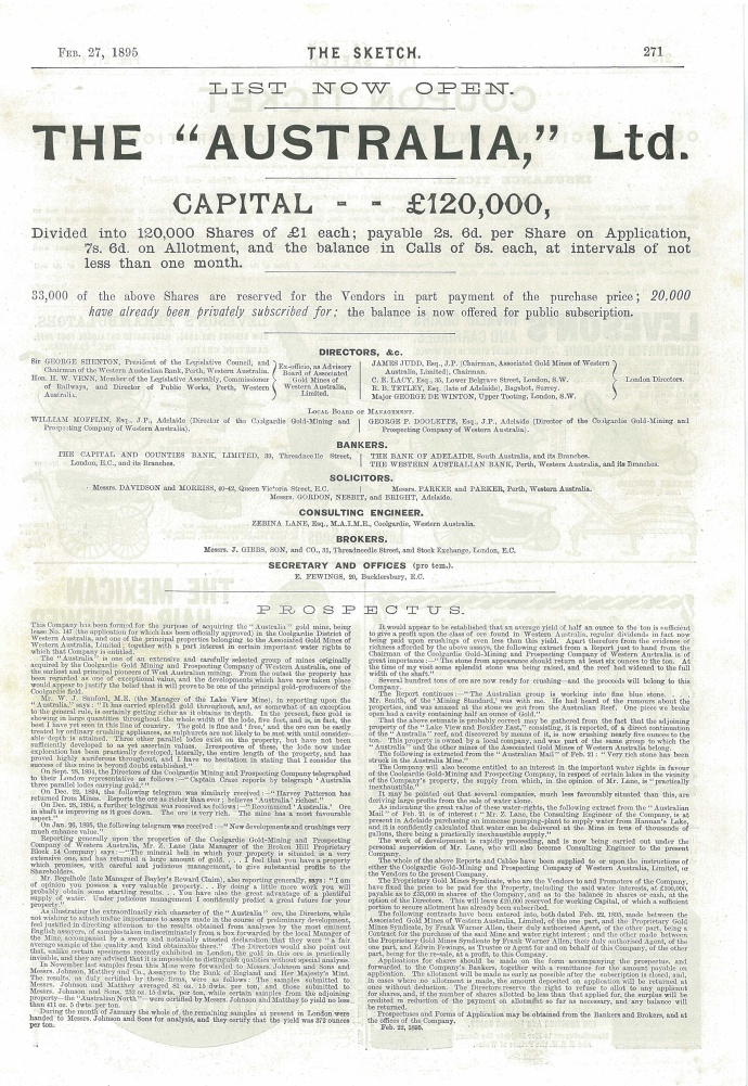
australia prospectus

Prospectus for the Australia Gold Mine of which Bottomley was to become Managing Director.  Coll.  Bob Singer

His tactic was to promote to build vendor profits, by pushing the stock price for a short time, issuing a 20 per cent dividend and then letting it decline to liquidation or reconstruction. Thus, almost without exception, Bottomley’s companies were liquidated within a short time with most of the capital going to the promoters

Besides using the vehicle of promotions, Bottomley invested extensively in Associated Gold Mines of Western Australia and in the Great Boulder, companies that gave him a very handsome return as well as lending the appearance of substance to his activities.  Many of his companies included the word “Associated” in their name.

associated financial 1900

One of Horatio Bottomley’s financing vehicles.  Note signature of Bottomley.  Coll.  Bob Singer.

Bottomley’s brief but profitable career in the Australian mining sector of the London market was soon to end. The initial boom had waned and the gold mining industry on the Eastern Goldfields of WA was seeking to develop mining on a large scale.  In July 1897 Bottomley changed tack and floated the West Australian Market Trust which he claimed would have “large and, perhaps, controlling interests in many of the best things in the West Australian market”. However, by the next year it was in serious difficulty with Bottomley losing heavily as the share price collapsed.  Without the equivalent of Wright’s Lake View Consols or Ivanhoe mines in the Trust’s stable, public confidence in it evaporated and by the end of the year Bottomley was forced to reconstruct the company.

Like Wright, he also manipulated production at the Associated mine and stock in the company in order to promote his other company interests and to add to his personal fortunes. Late in the 1890s production at the Associated yielded spectacular results when the mine manager was instructed to stockpile rich ore for strategic processing. In mid-1900 when the deception was clear, it was reported that reserves of payable ore had been overestimated by 75%. As well, Bottomley had successively issued new capital in the company, using part to finance dividends. When production declined and the extent of overcapitalisation became apparent, the inevitable market bears (including his nemesis, our old friend Whitaker Wright) ended Bottomley’s “mining” of this section of the “stock market stope”.

associated southern

Share certificate for Associated Southern Gold Mines Ltd, a Bottomley company.  Coll. Bob Singer

From 1893 to 1903 it is estimated that Bottomley launched about fifty mining and finance companies with a nominal capital of between £20 and £25 million. His personal wealth at the time was estimated at about £3 million.

Bottomley maintained a superficial respectability as a businessman but remained a superlative con man.  He escaped prosecution for his deeds during this period and later went on to indulge in further nefarious activities which resulted in bankruptcy three times (1912, 1921 and 1928), losing his seat in Parliament (twice) and serving seven years in prison for fraud, eventually becoming an alcoholic and losing everything before dying intestate in 1933.

Bottomley and Wright and a host of other speculative promoters, had negative consequences that hampered the early development of gold mining on the Golden Mile for many years, making it extremely difficult to raise capital for the legitimate operations.  It also set in place a tradition and reputation which continued to be enhanced by the activities of Claude deBernales in the 1930s and Alan Bond and “WA Inc” in the 1980s.

But that’s another story.


Categories: Western Australia | Tags: , , , , , , , , , , , , , , , , , , , , , | Leave a comment

The stunning beauty of Harry Clarke’s windows. St Barrahane’s, Castletownshend, Cork.

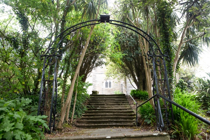
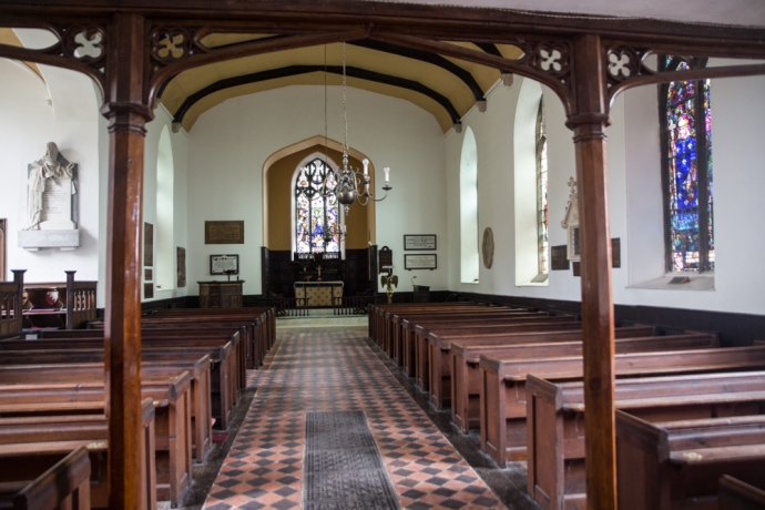
Eight kilometers from Skibbereen in West Cork is the village of Castletownshend, the historic seat of the Townshend family.   St Barrahane’s Church, built in 1827, sits on a hill above the village. It is accessed by 52 steps. One for each Sunday of the year. It is an elegant building with many original interesting architectural features and some fine detailing, both internal and external, including timber paneling and an organ gallery.

IG3C2752

St Barrahane’s Church

IG3C2660

The last 13 of the 52 steps to the church

IG3C2664

Simple and elegant interior

IG3C2722

The organ gallery

Of greatest interest though to visitors is the addition in the early 20th century of six magnificent stained glass windows.

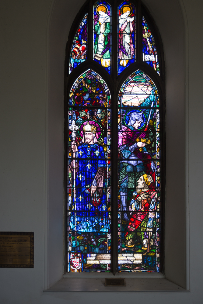
Three of these are by Harry Clarke, a book illustrator and Ireland’s most famous stained glass artist, who died in 1931, and three are by Powells of London. It is not hard to pick those by Clarke.  They are characterised by beautiful, finely crafted, elongate figures and his use of deep rich colours. the wall to the right of the altar has three windows with the Clarke window, on the right, being quite distinct and obvious.

IG3C2734

The Harry Clarke window is on the right.

IG3C2665

The Louis and Martin window by Harry Clarke

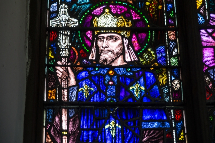
This window depicts French Saints Louis (who was Louis IX, King of Spain) and Martin and was commissioned in memory of a Colonel Coghill in 1921. A window of two lights, the first light depicting St. Louis who was an ancestor of the Colonel. The figures above his head represent the poor who he often fed at his table. The first of the tracery lights depicts a ship in which King Louis sailed to the east to fight the infidels. The second and third tracery lights depict two angels who offer protection to both saints. The fourth tracery light shows St. Martin’s flaming sword, denoting his patronage of soldiers,  The second light depicts the meeting between Saint Martin of Tours, dressed as a soldier’s garb, and a beggar who asks him for clothing.  Again the imagery is imaginative, stunningly crafted and in glorious deep colours.

IG3C2668

Detail of St Louis

The largest window, known as the The Nativity window, was commissioned in 1917 in memory of the Somerville family.  This window has three lights, with separate depictions of the shepherds paying homage to the Christ child, the holy family and the magi but with linking elements such as Mary’s dress and the crib that create a unified picture. They are exquisitely decorated in shades of blue, pink, green, red, purple, magenta and gold. The tracery lights depicts three saints, Brigid, Fachtna and Barrahan in gorgeous detail.

IG3C2705

The Nativity window

IG3C2709

Detail of the Nativity window

IG3C2713

The three Saints in the Nativity window

When you look at these windows from outside the church, you can have no expectation of how stunning the images are when back lit.

IG3C2751

The Nativity window from the outside

If you a visiting West Cork you really must take a peek. Or look for Clarke windows in Dublin and many other locations in Ireland and England.

He completed over 130 windows.  You can find where they are here  https://en.wikipedia.org/wiki/Harry_Clarke

Categories: My Journey, Real Ireland | Tags: , , , , , , , , , , , , , , | Leave a comment

The Colorado Rockies 4. Independence – a Ghost Town.

Independence ghost town

In my last blog on my road trip through the Colorado Rockies, I talked about Independence Pass and its close connection with the discovery of gold. Gold in this part of Colorado was discovered on 4th July 1879 at Roaring Fork River about four miles from the top of the Independence Pass and a town soon sprung upon the banks of the river and in the shadow of Mt Independence. It started as a tent city and one year later there were 300 people living in the camp.  The following year a single company, Farwell Mining Company, had acquired the leading mines such as Independence No 1, 2 and 3, Last Dollar, Legal Tender, Mammoth, Mount Hope, Champion, Sheba, Friday, and Dolly Varden.

IG3C1227-Pano-2

The ghost town of Independence at the foot of Mt Independence in the valley of the Roaring Fork River

Various competing interests battled over the name of the town.  During its short life it was variously known as Belden, Chipeta, Sidney, Farwell, Sparkhill and in its fading days optimistically Mammoth City and Mount Hope.  Ironically though and for obvious reasons, it was widely known as Independence though there was never a post office of that name.

By summer of 1881 there were 500 people and many permanent buildings including grocery stores, boarding houses and three saloons. It reached its peak in 1882 when there were 90 buildings containing 40 businesses and a population of 1,500.

As with most mining booms, the bust followed quickly when the gold ran out and by 1888 there were only 100 citizens eking out an existence at an elevation of nearly 11,000 feet and under a blanket of snow from October to the end of May.  The worst storm in Colorado’s history hit in 1899 and those residents still there were completely cut off for months. Running out of food, they dismantled their houses to make skis and 75 residents skied their way to Aspen. Only one resident remained after this. Jack Williams was caretaker of the stamper battery and treatment plant.  In 1912 Jack finally left and that was the end of the town of Belden-Independence-Chipeta-Sidney-Farewell-Sparkhill-Mammoth City-Mount Hope.

IG3C1276

A restored miner’s cabin now used as a summer residence.

IG3C1279IG3C1289

Incredibly a number of buildings have survived to varying degrees in this spectacular location. Some remain relatively intact and have been restored and some are piles of timber or just depressions in the ground. Ted Ackerman’s Hotel was one of five during its hey-day. Little remains of this establishment where miners could find a room for $2 a day.

IG3C1239

Ruins of Ted Ackerman’s Hotel

A general store stands proud, restored in the 1980s and a remarkable testament to the courage of these men (and a few women) and the lure of gold.

IG3C1261

Restored general store

As a geologist with a strong interest in the company history and social history of gold mining in my home country I have seen many Australian ‘ghost towns’ from the gold rush days. They were much more transient and rarely does any structure survive as here. Australians built with hessian and stone and corrugated iron, rather than timber, which is so abundant here, and material was transported to the next town following abandonment.  You’d have to say that heat was more of a problem than cold generally.  Its hard not to be impressed though by the simplicity of construction of the log cabin and its durability.  140 years later the v-notch joints still hold the structures together.


Just downstream from the town is the timber framework of a large stamper battery and on the slopes above there is a bit more mine infrastructure, the head of a mine shaft and a patch of Aspen covering what was obviously a spoil dump.  I would love to have had time to explore more.

IG3C1319

Remains of a  large stamper battery.  The treatment plant would have been on the flat area below.

IG3C1316

An old mine site.  The mound in the distance was the head of a shaft and the patch of aspen covers a spoil dump.

Preservation of these sites is essential.  They are one of the few tangible links to a hugely important part of the development of countries such as USA and Australia.  As in Australia, mining was responsible for opening up large tracts of the country and for the beginnings of many towns, some gone like Independence, some still surviving like Aspen, Leadville or Cañon City.  I’ll come back to this in a later blog.

Categories: America | Tags: , , , , , , , , , , , , , , , , , | 2 Comments

Of Magic Mushrooms and Ancient Ireland

There are a number of major ancient Royal Sites in Ireland but the four important ones were the seats of the four provinces. These are Cashel for Munster, Navan Fort for Ulster, Dun Ailinne for Leinster and in Co Roscommon, Rathcroghan for Connaught. . There was also Tara with its special status as the seat of the High King.  There is evidence of activity at these sites from deep in the Stone Age, through the Bronze Age to the height of power in the Iron Age and into Medieval Christian times.

I visited Rathcroghan recently. Before the coming of Christianity this was the religious, ceremonial and political heart of the Kingdom of Connaught. There is a wealth of archaeology scattered over 6 square kilometres with 240 sites recorded of which 60 are listed. I visited the ring barrow mound of Rathbeg, probably continuously used over this entire period, the great mound at Rathcrogan, the site of major royal celebrations and the medieval raised ring fort of Rathmore. Not easy to photograph from the ground, where they appear as grassy mounds but their sheer size and concentration are impressive.

IG3C5477

The ring barrow fort at Rathbeg

IG3C5541

The ceremonial mound at Rathcroggan

IG3C5553

The ring fort at Rathmore

But I wanted to talk about something else.

I met a fellow at Rathbeg. I’ll call him Patrick.  I’d watched him slowly walking the fields around the mound, head down searching. Is he looking for stone axes or ancient relics?

IG3C5503

Patrick searching the fields around Rathbeg

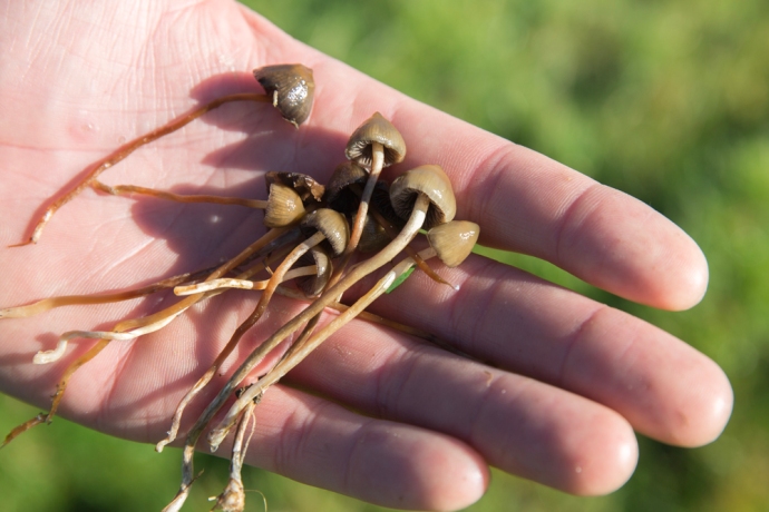
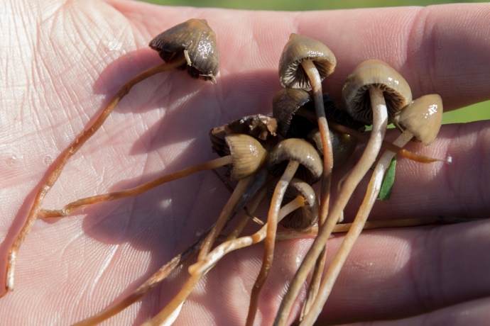
We had a chat and the answer was not what I expected. He was searching for psilocybin better known as magic mushrooms. Patrick had a little bag full after an hour of searching. He told me he takes one dried every four days to manage his headaches and migraines and has been doing so for sixteen years. We searched together for a while but the slender bulbous fungi proved elusive.

IG3C5497

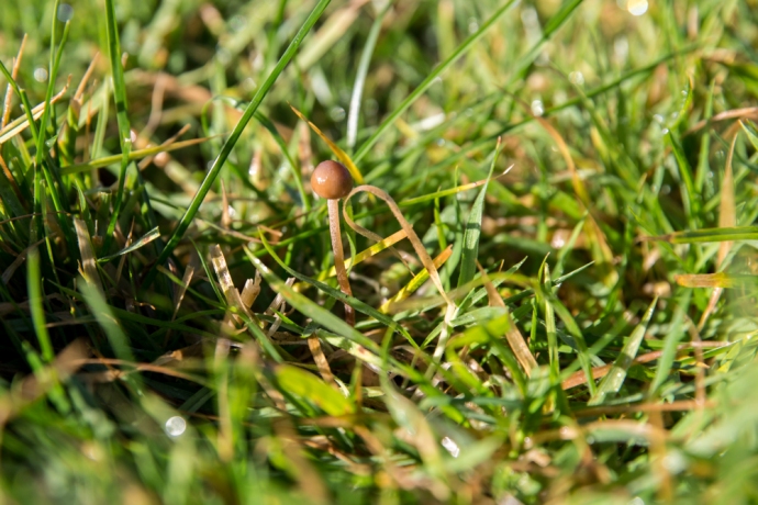
A magic mushroom pokes through the grass

IG3C5489

Part of Patrick’s harvest

IG3C5493

Detail of magic mushrooms

Magic mushrooms are among the oldest recreational drugs that human beings have ever used. They are believed to have been used for over 5,000 years down to the pop culture of today.

Hard evidence of its use in ancient Ireland is scant but this is hardly surprising. Indirect evidence however suggests widespread use in neolithic times. The rock art in Knowth and Newgrange is thought by some archaeologists to reflect the psychedelic state of the artist. Many traditional Irish tales seem to disguise the psychedelic experience in metaphor. For example hazelnuts accidentally ingested by Fionn mac Cumhaill, which gave him wisdom and pleasure, are though by some to be liberty cap or amanita muscaria mushrooms. Old stories of St. Brendan, refer to .him finding “fruits” – some poisonous, some euphoric that staved off hunger. Visions of faeries are so strongly associated with mushrooms that the Gaelic slang for faeries and mushrooms is the same: ‘pookies’. A magic mushroom trip has you “away with the faeries.” Or “off with the pixies.”

But what I found really interesting was Patrick’s comment that he has found the best place to find these mushrooms was at Ancient Sites. His idea was that it was the reason the sites were there and that mushrooms formed a fundamental part of their religious, cultural and social fabric.

An intriguing thought.  I left him to his searching.

Categories: My Journey, Real Ireland | Tags: , , , , , , , , , , , , , , | 1 Comment

An Ancient Coast and 5,000 years of Irish history. Maghery in Beautiful Donegal.

One of the things I love about touring in Ireland is that you find so much to enjoy in the most unheralded and remote corner of of the country.  You don’t need to join the throngs of visitors kissing stones, ticking boxes and visiting interpretive centres to enjoy the ‘real’ Ireland.

Take the village of Maghery in the the area know as The Rosses near Dungloe in west Donegal.

What drew me there was a sunny Donegal Saturdayin late autumn and a vague knowledge of some sea arches at nearby Crohy Point, a spot favoured by photographers.

IG3C3538

Clohy Sea Arches

But I found far more.

Yes there was the Bristi Stack and the Clohy Sea Arches. Unique land forms such as these are found dotted up and down the Irish coastline. It was easy enough to find the location along a scary single lane cliff road. And I mean scary; you have no choice but to rely on the other driver to be doing the right thing.

The Clohy Sea Arches are marked on GoogleMaps but not on the ground. Clearly they don’t want people stopping. There is space for two cars to park on the verge and you can’t actually see the rock formations from the road. Feeling that sense of welcome provided by a locked farm gate you climb it and follow a track that leads toward the coast and down the hill where you get your first look at the unusual triangular arch.

IG3C3600-Pano

Panoramic view of Clohy Sea Arches

IG3C3616

The Bristi Sea Stack

Nestled in a small bay it is accompanied by a number of pinnacles which are the remains of similar collapsed arches. There is another quite different arch attached to the mainland at the other end of the bay where the rocks are dragged into near vertical by a fault which has since eroded out.

IG3C3590

Natural bridge formed by erosion of fault fill material

The Bristi stack was first climbed by professional sea stack climber Iain Miller in 2011. If you are contemplating it you need ropes, a dinghy to get there, amazing skill and a whole lot of heart.  Not for me but have a look at this video on climbing Bristi Sea Stack

Bristi-Stack

That’s Iain Miller stands on Bristi Sea Stack.  Unknown photographer. Unknown date

For more sedate pleasures I drove back to the village. Past the 1804 Signal Tower, like many others that dot dozens of remote headlands and islands along the west coast of Ireland. Built to give warning of an impending invasion by Napoleon.  This one looks to be in excellent condition. I wasn’t up to the hill walk to get there this day. Thanks be to long lenses.

IG3C3507

View in the vicinity of Maghery.  Napoleonic signal tower.

IG3C3638

Napoleonic signal tower

The village itself lies adjacent to a beautiful wide sandy strand. This Saturday it was empty except for the local equestrian group practicing their show jumping in this idyllic location. Happy horses indeed.

IG3C3988

Maghery nestled in the bay

IG3C3813

Practicing show jumping on the beach at Maghery


Hand painted signs on slate placed by the roadside led me to other points of interest. There is an impressive stone circle just north of the village.  Again you are left to your own devices; there is no marker on the ground and no directions as to how to get there.  Twenty metres in diameter and a bit overgrown but some diligent searching found this 4-5,000 year old monument. These circles are very rare in west Donegal, I believe.

IG3C4049-Pano

Termon Stone Circle

From here you get a sense of that Donegal wildness as you look to the north east across Dungloe Bay towards Mt Errigal 23 km away on the horizon.

IG3C4012

View across Dungloe Bay to Mt Errigal

Nearby is Termon House built in late 18th century and once owned by the local clergy sits on its own glorious beach. It is available as a luxury holiday rental.

IG3C4006

Adjacent to the house are some impressive walls built as work relief for those affected by the famine of 1847.  Hence ‘Famine Walls’.  Apparently the government refused to support the then landowner who ended up footing the £1,500 cost of paying his labourers 1d a day to build the wall. Beautifully constructed though they remain standing 170 years later.

IG3C4068

The afternoon was closing in and I could hear  the ringing sounds of twenty fiddles filling my head with mazurkas and schottisches so it was time to return to Glenties.  I was well satisfied with this little village that delivered a slice of Donegal’s wild coastal scenery and its human history of over 5,000 years.


Categories: Real Ireland, Wild Ireland | Tags: , , , , , , , , , , , , , , , , , , , , , , , , , , , , | Leave a comment

Dursey. An island at the end of Ireland.

Dursey Island lies at the end of the Beara Peninsula in West Cork. It has been inhabited since antiquity and though it lies only 200 m from the mainland it has always been one of the most remote and inhospitable places to live in in the whole country.

IG3C3006

Dursey Island looking towards the mainland.

It had a tortured early existence and was the site of one of the most horrific events in Irish history.  Following the Battle of Kinsale and the defeat of Donal Cam O’Sullivan at Dunboy in early 1602, the English moved to clean up the last of the rebels.  Many of the O’Sullivan Clan’s non-combatants had been sent to  Dursey to keep them out of harm’s way.  An English force attacked the small garrison guarding the island. They butchered the entire population of the island, women, children and the garrison. Three hundred people executed on the cliffs and their bodies (some were still alive) cast into the sea.  O’Sullivan survivors from the whole of the Beara Peninsula, about 1,000 of them, then marched 550 km north to seek shelter from the O’Rourkes of Leitrim, but that’s another story.

As with the rest of the west coast of Ireland, Dursey suffered during the famine with a 30% reduction in its population in the 1840s.  Its subsequent and continuing depopulation reflects that of many other Irish islands but its survival displays the resilience and strength of its people. In 1860 the three villages of Ballynacallagh, Kilmichael and Tilickafinna,  a population of around 240 eked out a lonely life on the treeless but well pastured island.  By 1969 this number was down to 53. A feature of the island now is the large number of abandoned houses from these times.  This eloquently tell the story of a disappearing population, but they also give the island its remarkable character.

IG3C2842

Abandoned village

Up until 1970 the only way to get on and off the island was by boat across the channel.  A channel that could become so treacherous with storms and a tidal surge  that for a month and a half each year the island was completely cut off.  Considering that there was no electricity, TV, doctor, priest, food supplies and no hall or pub, life must have been very bleak indeed.   After much agitation from islanders the Government agreed to build a cable car to provide a lifeline and, while that did save it from the same fate as the Blaskets, which were abandoned in 1953, it did not stop the population drain until, by 2011, there were only three permanent residents.

IG3C2411

Treacherous tides and surges made this channel very dangerous to cross.  Not these days.

IG3C2448

Approaching the island

IG3C2435

Anticipation. A picture window.

But the cable car opened the island to the tourist.  6.5 km in length, there is much of interest.

To walk the island takes at least 4 hours but I spent over 6 hours ambling and rambling, getting lost and finding myself again.  Just absorbing the ambiance and grateful for the glorious sunshine and the warm breeze that accompanied me. It is glorious to walk either along the sometimes paved road (which despite the alarming speed sign is almost devoid of vehicles;  I saw only one) or across the hills but best to stay on the marked paths unlike me.

IG3C2470

There is a marked walking trail across the hills.  Looking across to the mainland.

IG3C2486

If you leave the path walking through thick vegetation and across stone walls can be a challenge.

IG3C2790

I can never understand Irish speed limits.  100 kph!?

IG3C2880

Looking from the western tip of the island back towards the mainland.  A signal tower stands on the highest point.

On your walk you will come across the remains  of St Mary’s Abbey, a Napoleonic signal tower, historic ruins, spectacular views, rocky cliffs, birds galore, native orchids and your best chance  in Ireland to see dolphins and whales.

IG3C3170

St Mary’s Abbey

IG3C2623

Cliffs on the southern side of the island

IG3C2647

Dolphins

IG3C2727

I tracked this pod of dolphins for over half an hour down the coast

IG3C2928

Native orchids are common

At the western end of the island are three small islands.  Well, rocks really.  They are known as Calf Rock, Cow Rock and yes, you guessed it, Bull Rock.

IG3C2799

Looking west across Dursey to the imposing Bull Rock, two miles off shore

IG3C2889

Cow Rock and Bull Rock

A lighthouse was established on  Calf Rock in 1866.

Less than three years later a storm damaged the lighthouse.  This led to another tragic event in the saga of Dursey.  The Keeper, on Dursey, thought he saw distress flags and six boatmen were dispatched.  Those on the island were safe however, on the the return trip, the boat capsized and all six were lost

On 27 November 1881 in another  violent storm the the tower and lantern just snapped off above the steel base and fell into the sea. No one was hurt but it took two weeks to extract the four men stranded on the island. You can still see the base of the tower to this day.

IG3C2897

Calf Rock with the remains of the steel base of the light tower. Wrecked in 1881

To replace this lighthouse one was built on nearby Bull Rock, work commencing in  1882.  The light didn’t open until 1888.  It is worth pondering the challenge of constructing this on an island of precipitous cliffs measuring 230 m by 160 m and rising to 90 m above sea level.

The station consisted of an octagonal lighthouse tower, dwellings for the Keepers, and an oil-gas works.   This was a massive undertaking and the optic was the biggest in Ireland.

IG3C2915

Bull Rock with its lighthouse.  You can also see a gull colony and the entrance to a natural tunnel that goes right through the island.

The light still stands proudly today though it was automated in 1991. The island is swarming with gulls.  Also noteworthy is a natural tunnel that goes right through the island.  You can see the eastern entrance in the picture above.

That’s Dursey.   Take everything you think you’ll need because there are no supplies on the island and not even a toilet. And it won’t always be mild and sunny as it was for me; go prepared for bleak and wild.

But don’t miss it.

IG3C3225


Categories: My Journey, Real Ireland, Wild Ireland | Tags: , , , , , , , , , , , , , , , , , , , , , , , | Leave a comment

The Fergus. Ennis’ Forgotten River.

Many Irish towns are built on a river. This had obvious logistical, transport and strategic benefits and of course is not unique to Ireland.  Ennis’ name pays homage to this and derives from Inis Cluana Rámhfhada, an island formed by two forks of the river.  That river is the Fergus.  It rises west of Corofin and enters the Shannon Estuary after a journey of 60 km.

One dull April day, with spring making a late attempt to burst through, while I waited for my car brakes to be fixed yet again (one of the prices you pay for being shrouded in salt spray on the edge of Ireland), I decided to walk the Fergus River.  This proved to be more difficult than I thought.

IG3C1240

Fergus River looking south to the bridge at Abbey Street

While the river twists its way through the town, for most of its length it is well hidden.  It struck me that maybe Ennis doesn’t regard it as something to utilise or promote,  just an obstacle to be crossed.  Indeed six bridges cross it and the layout of the town is very much controlled by the loops of the river.

IG3C1535

Bridge at Bank Place looking west.

IG3C1480

Footbridge over River Fergus

IG3C1372

Clon Bridge

IG3C1655

Victoria Bridge

Where you can find it, the banks of the river either have a high stone wall that restricts view and access or are hideously overgrown and littered. Yes I know the river floods but surely space could be found for a park or a bit of open space where you can sit. And if there are seats they are facing the other way or you stare at a wall. You can’t even get to the river at the historic Steele;s Rock.

IG3C1255

Steele’s Rock on River Fergus

IG3C1311

Building on the banks

IG3C1317

River edge on New Street

IG3C1539

Riverside seating.  You need eyes in the back of your head.  Converted cornstores in the distance

In the town proper only very short bits of the river can be approached.  The one exception is the River Walk a part of which is a designated Sculpture Trail.  The walk runs from a car park near the town centre (unfortunately much of the river edge is used for car parking) to the Old Mill and then the short distance to Victoria Bridge. There is quite a bit of interest along the way in addition to the sculptures, including apartments converted from old cornstores, sluice gates and the remains of the Old Mill. But it’s all too short.

IG3C1560

Sculpture ‘Fishy Tale’ by Carmel Doherty on the Sculpture Trail

IG3C1605

Sluice Gates on Fergus.

IG3C1689

Sluice Gates.  Another view.

IG3C1588

Remains of the Old Mill.

If you try and follow the river the other way (to the east), you soon lose access.  It is built up all the way to the Clon Bridge.  Beyond this a small walkway runs parallel to a set of rapids but the weed covered banks seem only useful as a repository for abandoned shopping trolleys.

IG3C1429

Walkway on the Fergus near Clon Bridge.

IG3C1420

Cascades on the Fergus near Clon Bridge.

IG3C1427

Weeds and lost trolleys

I couldn’t help but notice one large area of apparent wasteland between St Coulmba’s Church and the river. There is direct river frontage,  and the geese and ducks seem to be the only inhabitants this time of the year. This would make a perfect Riverside Park. I asked a young traveler lad I met along the path why it wasn’t. “Too boggy” he said dismissively.  Maybe; but if there was a will I’m sure it could be overcome.

Unfortunately I found only one spot in Ennis, near Clon Bridge,  which you could loosely call a park and even it was walled off and paved with gravel.   Anyway just saying. It’s what this town needs.

IG3C1543

Suitable for a Riverside Park?

IG3C2601

A wide area of open land

IG3C2568

with direct access to the river… paddle boats?

IG3C2541

and with a beautiful backdrop


IG3C1437

Open space on the river edge near Clon Bridge.

Lastly there is hardly anywhere to eat or enjoy a coffee on the river bank except The Rowan Tree which is a wonderful exception and maybe O’Briens Cafe.  But again there is a wall. I hear it everywhere though.  ‘Ah, yes but what about the weather?’  but, hey, when the sun shines where do you go?

C’mon Ennis.  Embrace your river.

IG3C1487

The Rowan Tree Cafe.  Riverside dining.


Categories: My Journey, Real Ireland | Tags: , , , , , , , , , , , , , , , , | Leave a comment

Blog at WordPress.com.