Posts Tagged With: travel

Castlespotting at Caherush, Co Clare.

Caherush Point on the coast of County Clare, was my home in Ireland for over five years.  I walkled its shores many times revelling in its biological and geological diversity and its history; of farming and fishing, and seaweed gathering and quarrying.  I had heard persistent stories of a castle at Caherush Point but  I had never been able to find it or anything of its ruins. I decided to fix that situation before I left and in the week before my departure I went castlespotting.

I had a vague idea of where it was. Indeed the townland name holds a big clue. Caherush is from the Irish Chathair Rois which means ‘castle of the woods’ or ‘castle of the promontory’.  So I looked for a promonontory; any woods are long gone. Through this clever bit of deductive thinking I identified an obvious candidate on a grassy knoll that protruded onto the rock platform at almost its most westerly point.

castle-5498

Caherush Point.  The site of Castle Caherush, an O’Brien family Tower House.

There was little there thought to hang your hat on, until I spotted, half buried and overgrown, the remains of walls built from flat stones with sharp right angles that almost certainly would have been foundations or some sort of retaining wall.  Other flat stones arranged into a wall can be seen at the top of the cliff face looking south from the rock platform.  These are the only evidence of a former tower house, much of which was probably washed into the sea centuries ago on this exposed point.

castle-5507

Parts of walls, probably from foundations of Caherush Castle.  Looking across Mal Bay to Spanish Point.

castle-5462

Part of a wall of flat stones seen from the rock platform looking south.

There is virtually nothing in the historic record.  But we do know the castle was occupied in 1573, as it was then that Turlough O’Brien and twelve men obtained refuge there when they escaped after being badly beaten in a battle with the northern tribes of Clare, led by Teige MacMurrough. I could find nothing else and 19th century archaeologists, such as Westrop, give it only passing mention.

What I found really interesting though is that the site is also the location of a kitchen midden. The castle appears to have been built on top of it.  Kitchen middens, which are essentially prehistoric rubbish heaps are located in a number of spots along the Clare coast especially at Lahinch, Fisher Street and Fanore.  Finds in these middens include hammer stones, scrapers, flints and axes along with shellfish and animal bones. Dating shows these are Neolithic (4,000 to 2,500 BC), though there are both earlier and later middens known.

castle-5396

Kitchen Midden exposed at Caherush Point.  Probably dating from Neolithic times

castle-5509

Close up of Kitchen Midden.  Comprises mostly shells.  One fragment of bone in the foreground.

At Caherush, much of the midden appears lost with only a small portion exposed. Taking care not to cause damage, I had my own little dig and found shellfish, fragments of (animal) bone and even a fragment of a large tooth.  No stone artifacts but this assemblage is consistent with it being of the same age as the other Clare middens.  I took a few photos and carefully replaced and buried the material back in the hole.

So Caherush Point was settled perhaps 5,000 years ago and who knows who has lived at this spot in the intervening centuries. Cattle graze contentedly now over the Point and, with the continuing ravages of the sea, I expect that in just a few centuries, or perhaps even decades, all evidence of the castle on the promontory and its previous occupants will be gone.

Categories: My Journey, Real Ireland | Tags: , , , , , , , , , , | Leave a comment

Ireland in Four Days (and Five Years). Day 3. On to Wicklow.

It’s Day 3 of my final roadtrip, in southeast Ireland.  Check out my earlier blogs as to how I got to Boris Carlow;  that just rolls off the tongue so beautifully I just have to keep repeating it. Boris Carlow.  By rights I should go home.  The forecast is not good, but I want to visit a nearby dolmen and the castle at Carlow and I’ve decided after that to head on to Avoca in Wicklow to see the old copper mines.  The sun was trying to break through so I hit the road at 9am.

It was only 30km to the Brownshill Dolmen, which lies only 4km east of Carlow town  There are over 1,000 dolmens in Ireland but this one is right up there with the best.  It is located in the middle of a large field (by Irish standards) and you know you are dealing with something unusual when  you can see it 400m away poking up over a 2m high crop  of ‘field beans’ (a fodder crop I had never seen before).

brownshill-2911

Brownshill Dolmen, visible over a crop of field beans.

What makes this one unusual is the size of the granite capstone; it is approximately 5 x 6 x 2 m.  Estimates of its weight vary, so let’s sort this out once and for all.  Volume, based on the above estimate, is 60 cubic metres.  Using a specific gravity of 2.7 (average for granite) and the formula

Tonnage = Volume x SG

we get a tonnage of 162 tonnes.  So that’s my guess, which happens to be greater than the estimates I have read, which range between 100 and 150 tonnes.

brownshill-2838

Front view of Brownshill Dolmen, showing its massive size compared with the two portal stones and the gatestone.

That is monstrous and certainly the largest in Ireland.  It is a portal tomb dating from 3,000BC.  The front sits on two vertical standing stones (portal stones) and between them is a gatestone. It slopes back to almost ground level where the rear of the capstone is supdported by a prostrate backstone.

brownshill-2842

Rear view of Brownshill Dolmen showing prostrate backstone.

Of course, the most asked question is “how did they get it up there?”.  Well here is my theory.  Most people assume that it was brought here from somewhere else.  Well it was, but by ice.  I think it is a glacial erratic and was dumped here after the glaciers melted about 12,000 years ago.  Somehow, and I have no idea how, the front of the stone was lifted and supported with earth and stones until it reached the height of the portal stones (probably also glacial erratics) which were placed under the capstone to support it. The same would then hav been done with the backstone What we can be sure of is that it was built with sheer druidpower.

Now, time to  Follow Me Up to Carlow. I had to get that in. For those not familiar with the phrase it is the refrain from a 19th century song that describes The Battle of Glenmalure in Wicklow, fought on 25 August 1580, when a Catholic force demolished the British during the Desmond Rebellions. Just love the lyrics including this line….

Rooster of a fighting stock 

Would you let a Saxon cock

Crow out upon an Irish rock 

Fly up and teach him manners.

Carlow lies on the Barrow River, the same river that flows through New Ross and that is guarded by the Hook Head Lighthouse. (Check out my blog on Day 1).  My goal here was Carlow Castle, another of those built by the Norman strongman, William Marshall. It was built around 1210, to guard the vital river crossing.

carlow castle-2940

View of Carlow Castle from the west.

The original structure was pretty unique for Irish castles.  It was rectangular and had towers on each corner and appears to have been modelled on a Norman castle in France.  It survived pretty much intact until 1814 when a Dr Middleton accidentally blew it up in trying to convert it to a lunatic asylum (was a lunatic in charge of the asylum?).  All but the western wall and its two corner towers was destroyed. You do get a bit of a sense of the grandeur of the original building, though from what is left today.

carlow castle-2915

Two of the four corner towers of Carlow Castle that have survived

carlow castle-2953

View of the castle from the south showing the extensive damage caused to the building in 1814

I took a little walk along the river.   Graiguecullen Bridge crosses the Barrow, and dates to 1569 though it was significantly altered and widened since then.

carlow castle-2989

Graiguecullen Bridge dating from 1569 crosses the Barrow.  In the distance is the lime kiln tower of the old sugar factory.

In 1703 the decision was made to make the Barrow navigable.  This involved developing the non tidal stretch of the river from St. Mullins to Athy, (Co. Kildare), a stretch of 68 kilometres and requiring 23 locks. The locks are all functioning today and many have the original stonework.  I visited the lock at Craiguecullen and found an original milestone with the distances to Athy (12 Miles) and St Mullins. After Athy, it links up with the Barrow Line of the Grand Canal for another 45 kilometres, with 9 locks, to the mainline of the Grand Canal. That meant you could travel from New Ross in Waterford to Dublin by boat.  The Barrow ceased to operate commercially in 1959 and is now used for recreation only.

carlow castle-2981

Lock on Barrow River at Graiguecullen.

carlow castle-2971

Original (?) milestone with distance to Athy.

Looking north from the river the skyline of Carlow is dominated by an unusual looking tall steel tower which looks like nothing I have seen.  So I decided to find out what it was.  It was easy enough to locate, but it  but it sits on a wasteland with a high fence around it so I was none the wiser about what it actually was.

carlow castle-2997

Carlow limekiln tower

Turns out it is a limekiln and was part of the infrastructure of a sugar factory.  Yes, really, sugar. Ireland once had a vibrant sugar industry base on sugar beet, and Carlow was the centre of it.  A factory was set up here in 1926 and other factories followed in the 1930s in Mallow, Thurles and Tuam.  By 1936 there were 28,000 farmers growing sugar beet across 22 counties.  At its peak during the early 1980s Ireland produced 220,000 tonnes of sugar a year.   When EU subsidies were withdrawn in 2005 the Carlow plant closed and the only other remaining factory in Mallow also closed the following year, bringing an end to an industry that still supported 4, 000 growers.

The tower is twelve levels tall. Access was by steps around the outside with walkways at each irregularly spaced level.  I have no idea how it works.  Anyone out there know?  All trace of the factory other than the tower is gone.  In 2016 it too nearly disappeared when it was taken off the protected list.  It was saved at the last minute; but the battle between those who consider it part of the area’s heritage and those who consider it an eyesore continues.  A real shame if it is demolished. It would make a totally unique and challenging lookout tower.

Back on the road now to my next destination, a 60km drive to Avoca in Co Wicklow.  A quick stop first, about 20 km from Carlow, for another dolmen.  Haroldstown Dolmen is a beautiful example of a portal tomb and sits in the middle of a field, visible from the road adn easily accessible for a closer look.

haroldstown-3004

Haroldstown Portal Tomb


haroldstown-3024

Haroldstown Portal Tomb.  Side elevation.

My reason for going to Avoca was to check out its mining heritage.  As I have learnt more over the last five years I have been really surprised how rich Ireland is in historic mining sites and I have visited and blogged on a number of these including Arigna in Leitrim, Allihies and Mizen in Cork, the Copper Coast of Waterford, Silvermines in Tipperary and Muckross in Killarney. Really more should be made of in terms of its heritage value.

But as usual I got distracted.  Most tourists visit Avoca to see the Meeting of the Waters, the fabled location where the Irish bard, Thomas Moore, wrote perhaps his most famous song.  So that was my first stop.  The name comes from the site being the confluence of the Avonmore and Avonbeg Rivers to form the Avoca River

There is not in this wide world a valley so sweet
As the vale in whose bosom the bright waters meet,
Oh! the last rays of feeling and life must depart
Ere the bloom of that valley shall fade from my heart.

Meeting of the Waters-

The Meeting of the Waters. The Avonmore and Avonbeg Rivers meet to from the Avoca River, heading off into the distance.

It is a pretty spot there is no doubt. A small park marks the spot, with plenty of reminders of Thomas Moore’s historic presence.  There are monuments and the remains of a tree under which he is said to have written his words.   

Meeting of the Waters-3121

Bridge over the Avonbeg River at the Meetng of the Waters

Meeting of the Waters-3141

Monument to Thomas Moore and remains of a tree that he is said to have sat under to pen his words.

But for me the most moving ‘monument’ was another tree, this one alive, leaning out over the water.  Evoking the female form, it seemed to capture the spirit of the place.   I call the photo Undressed Timber.  Nature imitating Life imitating Art.  

Meeting of the Waters-3115

A tree at the Meeting of the Waters.  Undressed Timber.

I headed down the Avoca River valley to look for other treasures, lead, silver and copper, perhaps far from Thomas Moore’s mind.  Just a few hundred metres on and I could see a beautifully preserved Cornish Engine House, on the ridge above the valley.  I pulled up next to the Farriers Hotel, another indicator of times gone by.

avoca-3144

Farrier’s Inn near Avoca

avoca-3159

Cornish Engine House viewed from the Avon River

The Engine houses are a telltale sign that there was an underground mine nearby.  These marvellous buildings are a feature of mining areas throughout Ireland where they housed the steam driven engines that drove the beam pumps used to dewater the mines and to crush the ore.  I find the stone and brick buildings as architecturally impressive as the ecclesiastical ruins that get far more attention in the conventional built landscape.


I tried to get closer to the building but I was defeated by a high cyclone fence and the rugged terrain.  The only other remnant of mining at the site are two bins which stored ore before loading into trucks to take to the processing plant.

avoca-3184

Restored ore bins used to stockpile ore brought up from underground

Mining is believed to have started for copper here, in the Bronze Age (commencing 2,500 BC).  It is believed that it was still a mining centre in 50AD when the location appeared on a Greek map by Ptolomy.  From the 12th to 17th century iron was produced.  From 1750 it was mined for lead and modern copper mining started in 1812.

Continuing my search  I could see plenty of mine dumps and another Engine House from the top of the next ridge, but again I was thwarted in trying to get closer. I am sure there is a road up there but I’ll have to come back when I have more time.

avoca-3272

Distant mine workings. Another engine house appears among the mine dumps

Before leaving the mining area I went to visit the nearby Mottee Stone.  it is a giant granite boulder sitting on the top of a hill with 360 degree view over  the five counties surrounding Wicklow.

avoca-

Mottee Rock and the view over Wicklow

The huge rock is another glacial erratic (like the capstone at Brownshill) deposited by a melting glacier. We don’t know how far the stone was carried but the underlying geology here is slate.  The nearest similar granite is 13 km away at Glenmalure.  Iron rungs have been set into the stone to act as a ladder, which allows you to climb the 2.4 metres to the top.   The story goes that the local landowner wanted to impress his intended wife with the size of his estate, so he got some miners from Avoca to put them there so she could get a better view of the size of his holding.

avoca--2

Cronnebane Mine viewed from Mottee Rock

The most obvious feature in the view though is the large open cut and spoils heaps of the Cronnebane Mine. This is a later phase of mining completed between 1970 and 1982 when 8 million tonees of 0.6%Cu ore was extracted.

Heading towards Avoca village I passed the Old Castlemacadam Church overlooking the Avoca Vale near the village.  It looked different so I stopped.  Built in 1819 for the Church of Ireland it was abandoned after only a short life in 1870.  It is a solid structure with a belfry tower in good condition though unroofed and is surrounded by a graveyard full of interest.

church-3395

Old Castlemacadam Church

I found the external walls of the church interesting too.  They hold evidence of changing aesthetics and a number of different finishes.  The bare stone initially was covered with a render. Sometime later it was covered with a layer of slate shingles cemented onto the render.  Then another layer of render was placed over the top of the slates, leaving them in place.  This was scored with diagonal lines and there appeared to be another thin layer of render over the top of this.  It reminded me of a house I once bought in Leichhardt in Sydney.  I decided to renovate and lifted the carpet in the living room.  Underneath were two more layers of carpet and then a layer of lino over the now rotten floorboards.

As I said the church itself was built in 1819 but the graveyard has many 18th century headstones, the oldest is 1711.  So presumably there was an older church on the site.  No idea whether it also was Church of Ireland.  There are a lot of table grave slabs, way more than I have seen at other graveyards I have visited.   I am wondering if this is more of a protestant thing.

church-3376

Table slab graves

One thing I have seen in many cemeteries is a lack of engraved headstones from the 1840s to the 1870s.  I put this down to the effects of the famines and the extreme poverty meant many could not afford an engraved headstone.  There were often mass graves with no identifation or graves with simple markers that are now just illegible stones.  Here though are a number of engraved headstones from that period that are a poignant reminder of the terrible hurt that was inflicted on many families.  We can tell so much from a simple gravestone.  A couple of examples

John Dowling buried his 7 year old son John in September 1841. He died three years later at the age of 41

34_dowling

The headstone for John Dowling and his son.

Solomon Delaney was patriarch of the Delaney family. He died in 1824 at 63, and his wife Mary followed two years later aged 70.  They had 3 sons. John, Edward and William  Edward died early, in 1927 aged 27 years. Edward’s wife. Mary died soon after in 1829 aged 25. William died in 1843 (47) but was predeceased by his wife Ann as the famine took hold in 1840.    Their daughter Mary also died at this time. The gravestone simply says she “died young”.  John erected the headstone so he survived them all.

And perhaps most poignant of all is John Webster who lost his five children.  Mary (1843) aged 1, John (1846) aged 3, Thomas (1849) aged 6 months, Henrietta (1853) aged 1 day and Nanny (1857) aged 18 years Clearly the ravages of the famine affected catholic and protestant alike.

It was now nearly five o’clock and I was starving so I headed to the village of Avoca for a meal at the local pub.  Fitzgerald’s Pub.

Ballykissangel-3537

The pretty village of Avoca nestled on the the Avoca River.

Ballykissangel-3560

Fitzgerald’s Pub Avoca

It’s probably familiar to you if you were addicted to the late 90s BBC TV series Ballykissangel, as I was.   Avoca is Ballykissangel.   It was mostly set in this cute village.  Fitzgeralds’ Pub used to be the Fountain but it had a makeover for the show and they just kept it  Across the rooad is Hendley’s Store and the very familiar church up the road where Father Peter Clifford used to hear confession and the Priest’s House which is now a Gift Shop. The curved street will be very familiar to you if you were a fan of  the show.

Ballykissangel-3576

Hendley’s Store has hardly changed.

Ballykissangel-3583

The church and the Priest’s House

Ballykissangel-3564

The main street of Ballykissangel

I had dinner in the pub and just so I felt really at home, episodes of Ballykissangel were on constant reruns on a big screen in the dining room.  I watched Episode 2 of Series 1 when Jenny, an ex flame of  Father Peter arrives in town and sets off the rumour mill while Peter is busy trying to save a caravan family from harassment from Quigley, the town entrepreneur, who keeps dumping manure at the site.  Remember it?  There’s no sound and as I demolish a near perfect beef stew, I follow the action reading the subtitles.

Ballykissangel-3599

Continual reruns of Ballykissangel in the restaurant at Fitzgeralds

Tempted to stay and watch Episode 3 but I resisted.  One last walk through the town and I was back in the car heading to Bray where I heard there was a session at the Hibernia.  Three days without music and I was starting to suffer withdrawal symptoms.

Bray-3617

The beach at Bray

While I waited I took a walk along the seafront.  A lovely promenade runs the full length of the bouldery beach and the road is lined with cafes, bars, hotels and swish looking tenement houses.  One building of particular interest was owned by Oscar Wilde, who inherited it from his father in 1876.  It was built by Sir William and Lady Jane around 1850, as a holiday home and was later to become the Strand Hotel.

Bray-3676

Strand Hotel.  Former home of Oscar Wilde

It was a  great night of tunes with musicians Gerry and Paddy and a bar full of interesting people.  After they found out I was Australian, I ended up singing Aussie songs all nght. It was over all too soon and at 1 am I was out on the street.

Bray-3680

Paddy and Gerry, my musical comrades for the night.  

Literally.  I had actually neglected to book any accommodation.  I think part of it was my resistance to paying 99 euro for a night at a B&B.  Prices in Ireland have got ridiculous.  Resigned to a night in the back of the car. I was reluctant to park up on the seafront at Bray so I decided to drive to Sally Gap, 20-odd kilometres away.  Then I would be up on the mountain to catch the sunrise.  So that became Plan A.

While I was playing music however, the sunny day had turned into misty rain and as I gained elevation into the Wicklow Hills, the misty rain turned into foggy misty rain. With the limited visibility I pulled into the first roadside parking bay where there were no other campervans or cars parked  and settled in for, I have to say, a rather uncomfortable night.

I’ll tell you how it all panned out in my final post.

Categories: My Journey, Real Ireland, Sessions, Trad Irish Music | Tags: , , , , , , , , , , , , , , , , , , , , , , , , , , , , , , , , , , , , | Leave a comment

Ireland in Four Days (and Five Years). Day 1. From Tipperary to Hook Head

This is first for me.  For the last five years I have written blogs about my travels, but I have never written a travel blog.  What I mean is that I have talked about places I’ve visited and experienced but have never  written a travel diary as such.  As I prepare to leave Ireland, I am madly trying to see places that I have neglected or counties that I have not explored.  Wexford is the only county I have never visited.  Time to fix that.

Before planning any road trip, I am keen to ensure the best possible light for my photography, so I am an avid consumer of weather apps and unless there are other constraints (such as a music festival) I am lucky enought to be able to pick my time.  The hourly forecasts have become remarkably reliable as a predictor of sunshine, so on this particular Saturday, late in August it looked good for Sunday and Monday.  Next morning, I headed off with the plan of an overnighter to Hook Head.

A quik aside.  Travelling Ireland is in my mind unique.  It is compact and chock full of rich and varied experiences that cover millenia and everything is pretty accessible.  For me though, it’s not just about ticking monuments and sights off a list, it’s about the people you meet on the way, the side roads you take, the discoveries you make and colliding with the unexpected.  I wanted to post this to show those contemplating a visit that you can do so much better than just consulting the Lonely Planet guide book or leaving it in the hands of your tour operator.  And you can do so much more in limited time than anywhere else in the world.  If you can though you have to be flexible.  My planned two day trip to Hook Head ended up being a four day journey that took me through Tipperary, Wexford, Carlow and Wicklow.  In the process I saw pretty much everything that Ireland can offer.

I’m not expecting the average visitor would want to cram as much as this into a visit.  Perhaps you want to linger longer at one place.  I find each stop speaks to me about how long I have  to stay.  You just have to listen.  Some I was there only 15 minutes, others for 4 hours.  In Wicklow on the last afternoon, I walked for 12 km, unable to call it quits.

Most of the places on this visit I have never been to before. You see, even in an Ireland where I have been relentlessly touring for five years you can still do that.  There are constants but nothing is the same.  You never tire of the stunning scenery and the prehistoric or historic legacy that screams at you of conquerors, wars, pestilence, struggle and achievement.  Sure you can go to high profile, developed sites, where you can get a packaged and potted version of Ireland’s history, but for myself I like the Ireland that is hdden or the Ireland I discover by chatting to people on the way,

So, enough talk, do up your seatbelt and lets go.

Sunday morning’s start was later than I hoped, due to a session in Miltown Malbay the previous night.  My destination for the night was Hook Head, about four hours drive.  Plenty of time but nothing was set in stone.   That’s the way I like to travel these days.  I never know where I will end up and around five or six in the evening, I look for an Airbnb or B&B that suits or I just sleep in the car.  I find that travelling to a BB puts an artificial constraint to the day and makes it difficult to be where you want to be for the evening light, or for an early start and the predawn light that the photographer in me craves.

I’ve left Clare behind as I travel through Limerick when just near the village of Pallasgreen close to the Tipperary border, I noticed a brown sign  Very useful these brown signs.  Bob’s Fifth Law of Travel –

Brown sign + Google = discovery.

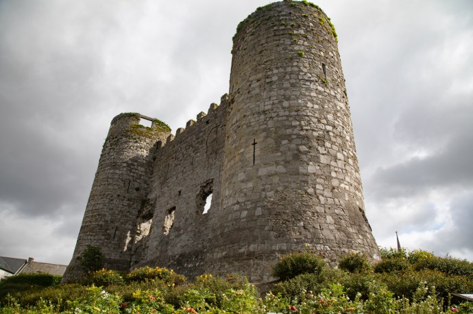
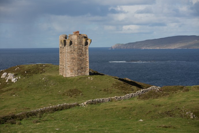
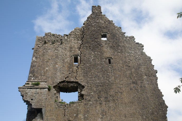
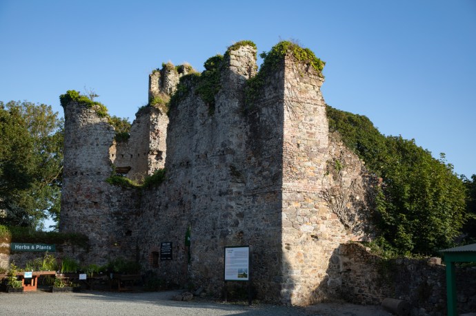
Kilduff Castle it said.  An evocative ruin of a 1550 Tower House, it was the home of the Hurley family until 1660s, when forced out by Cromwell,  Destroyed in 1688 during the Jacobite war it has been left in ruins ever since.  Access is restricted due to its perilous state.  Something tells me there will be a lot less of it next time I visit.
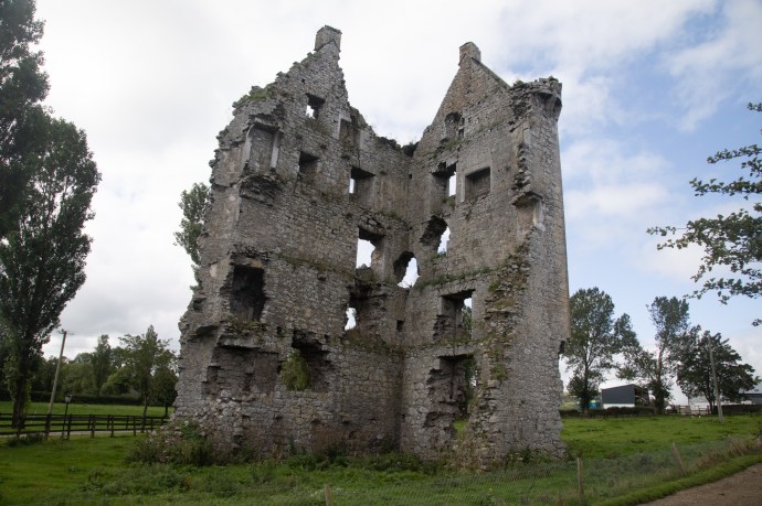
kilduff-0384

Kilduff Castle

kilduff-0420

Kilduff Castle.  Beyond repair?

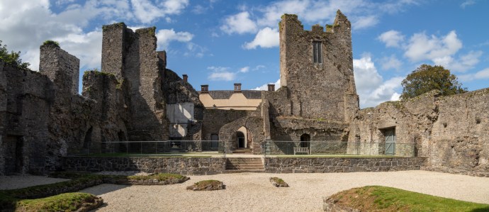
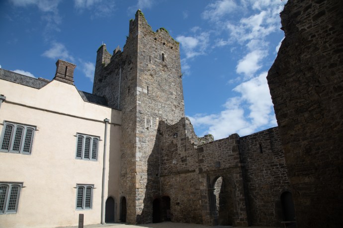
Then it was on to Cahir Castle, Tipperary.  There has been a fort at this location since the 3rd century but the castle that stands today was built in the 12th century by Conor O’Brien on a limestone rock jutting out of the river. Almost growing out of that rock it has been the site of countless attacks and sieges for centuries.

Cahir--3

Cahir Castle.

The powerful Anglo-Norman family, the Butlers, came into the possession of the castle in 1375 .  It was thought to be impregnable but, it was subsequently captured three times in its history: twice without a shot being fired.  It fell to Devereux, Earl of Essex, in 1599 after it had been battered for three days with artillery; it surrendered without a fight to Inchiquin in 1647 and again to Cromwell in 1650.  That man again!

Through all this though the Butlers managed to retain control until 1961, the last Lord Cahir died, and the castle reverted to the State.

It has looked the way it looks now since 1599 and is remarkably well preserved retaining its impressive keep tower, its original portcullis gate and winch mechanism and much of its defensive structure such as machiolations and canon.  I even spotted a garderobe chute (tipping its contents straight into the river).

The forecast of sunshine for the afternoon was spot on and the River Suir was sparkling. The ducks and geese were having as much fun as the visiting Dutch or Greeks.  To my mind, as with many of the ‘touristy’ reconstructed or restored castles it is a bit sterile and looks for all the world like a film set, which, not surprisingly, it has been for such films as Excalibur, Barry Lyndon and Tristan and Iseult.  And recently it was the location for a new film, ’The Green Knight’, a fantasy re-telling of the story of Sir Gawain who embarks upon a quest to confront the titular Green Knight. There is no denying the stunning views from every vantage point though.

Cahir-0745

Caher Castle and the geese and ducks on the River SuirEnter a caption

Cahir-

The Banquet Room, Cahir Castle

Cahir--2

View over the town of Cahir from the CastleEnter a caption

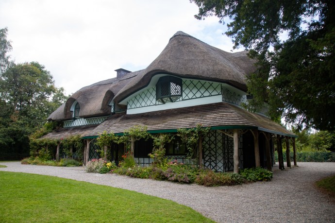
A short distance away, but in a parallel world, is the chocolate-box pretty of the Swiss House.  Not Swiss but given that name by the locals due to its idiosyncratic architectural style known as ‘cottage orné’ which resembled in their mind a Swiss chalet.  It was built in 1810 by the same Butlers, owners of the castle, as a rustic getaway.

swiss-0789

The Swiss Cottage at Cahir Castle

The style was meant to reflect the disorder in nature and blend in, so the roof isn’t level, windows are of different sizes and external oak timbers are meant to resemble roots.  A verandah surrounds it and makes it look bigger than it is.  The patterns in the trellis work change constantly as you move around and the house never looks the same from any angle. The iron fence of intertwining branches dates from 1850.  A Yew tree adjacent to the house is believed to be 1,000 years old making it one of the oldest in Ireland..  The cottage is now owned by the State and managed by OPW.  No time for a tour inside, but nevertheless a charming and very non-Irish looking diversion.

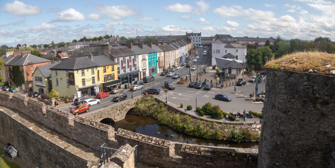
It was time to head on through Tipperary towards my destination of Wexford.  But one surprising deviation first.  My road took me through Carrick-on-Suir.  Some context here before I go on.  This is one of the most passionate of the hurling places in Ireland.  The county is renowned for its excellence in this most Irish of sports.   The weekend before, Tipp had won the All Ireland for the 27th time. The celebrations were still going on on the street.  I stopped at a place, which I later learned was named Sean Tracy Park.  [The name is in honour of Tipperary man Seán Treacy, one of the leaders of the IRA who was killed in October 1920, in Dublin, in a shootout.  His name is revered in West Tipperary and associated with hurling.]

It was festooned with bunting and flags and numerous placards of hurlers in a coordinated display of blue and yellow.  The bright sunshine had brought people onto the street, everywhere talking hurling and reliving the glory.  As I clicked away I heard a voice. “Are we gonna be on News of the World?”.  I had to disappoint him that it was only the News of Australia.  He told me that following their Senior win they had just won the Under 20s and that they were going for the Trifecta, with the Ladies playing the next weekend.

I learnt a lot that afternoon.  Of the passion for a uniquely Irish game and of a corner of the world where there was a real community spirit. In a world where many of us live our lives in reclusive isolation in front of a TV screen or on a hand held screen this was a refreshing flashback to a community existence where fences between houses don’t exist. I recalled vague memories of growing up in Sydney in the fifties, where life was lived outside, the street was your front yard and there were endless games of cricket.

I knew Tipperary was one of the Big Three in hurling.  In fact they won the very first All Ireland in 1887 and have won another 26 since including this year’s.  Preeminence in hurling is seen as a simple fact of life in Tipperary.  Michael Cusack, the founder of the GAA, once said   “Tipperary was the benchmark by which every other county would be judged.”  Looking at the street display I asked my friend from earlier, “Is all of Tipp like this”.  “Ah no he said.  “Carrick on Suir is special.”  As if to confirm this, I later found a reference to an article  from the Tipperary Advocate  of 1887 decrying the violence  in the game.  It reported “disgraceful scenes” in Clonmel when a game against Carrick developed into a brawl and ending in a bout of stone-throwing. The Gardai were called but it was a sense of continuing bitterness that Carrick men were blamed with no arrests of anyone from Clonmel.  It was a much more peaceful scene on this sunny Sunday 132 years later.  I wished him luck for the Trifecta and resumed my journey.

But I couldn’t leave Carrick on Suir without visiting Ormond Castle. Another of Butler’s many properties.  This one was a fortified Tudor Manor House (Ireland’s only such building) dating from 1560s.  What I found really interesting though is how this elegant building integrated and incorporated an earlier fortified castle dating from the 14th century and and not one but two Tower Houses of different ages.  Here I wished I’d had more time to look inside at the splendour of Thomas Butler’s house, built, it is said. to impress Queen Elizabeth I (for whom he had a bit of a thing).  Sadly she never came to visit.

osmond-0859

Front view of Ormond Manor House

osmond-

Rear viewo Ormond House taken from the 14th Century castle and showing the two tower houses.

osmond-0871

The 16th century Manor House abuts against one ot the earlier Tower Houses.

Leavng Carrick on Suir, to get to Wexford you must travel along the River Suir in Kilkenny until it meets the Barrow (the second longest river in Ireland) and then follow that north to its first crossing at New Ross.  On the way at Granagh, you are confronted by an impressive bridge over the Suir .  Just before the bridge is yet another castle, Castle Granagh, also known by the perhaps less threatening name, Granny Castle.  Another strategically placed defensive site on a bend of the Suir just west of Waterford, there was a Celtic fort built at this spot as long ago as the 1st century.  This one is a typical Norman castle with a courtyard and towers in each corner.  The large keep tower may have been added in the 15th century.  Originally built by the Power family, when they fell out of favour it was granted to, yes, the Butlers, in 1375. Until, yet again, in 1650 taken by Cromwell and destroyed.  History definitely keeps repeating itself around here.

Granny-

Castle Granagh

Three intrepid (or should I say foolish) lads managed to get inside one of the corner towers.  A perilous exercise and not for the faint hearted.  I am happy to report that they got out ok.

I grabbed one more look at the view that juxtaposed a bold architectural statement of the 21st century bridge with a castle that combined elements of the 13th, 14th, 15th and 17th centuries, before I was back on the road to Wexford.

Granny-0951

Granagh Castle and the bridge over the River Suir

It was 4.30 pm when I got to the historic riverside port town of New Ross, with its the three-masted tall ship, The Dunboy Famine Ship, dominating its skyline.  I had to pay a visit, though I hadn’t intended to stop. There I discovered yet another Interpretive Centre, Restaurant, Cafe and Museum complex, and another request for €9.  The Dunboy is actually a replica of a ship that was genuinely used in the 1840s and it is open to the public.  Resigned to parting with my €9, I thought I would have a look.

Dunboy--2

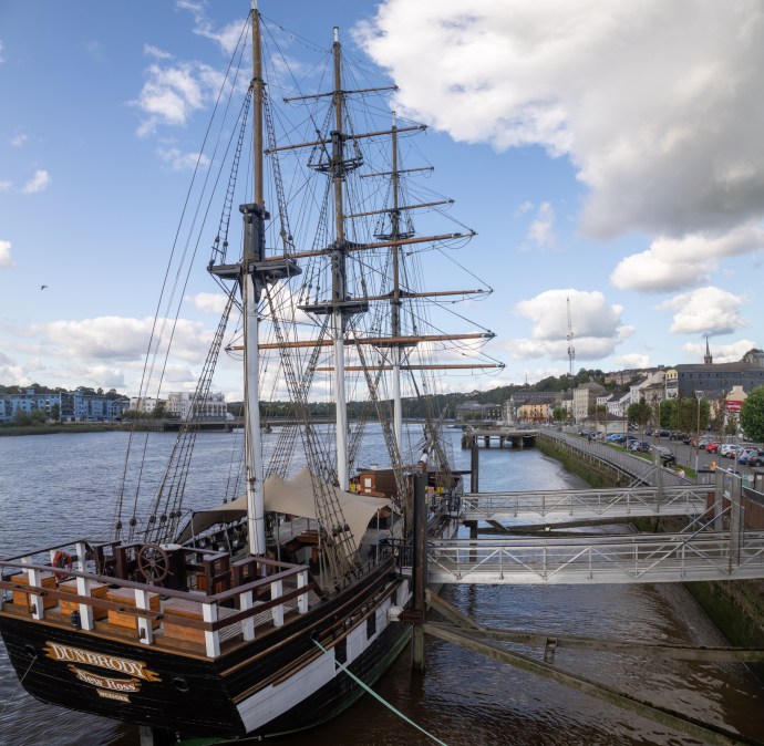
The Dunboy Famine Ship and the River Barrow at New Ross

“Yes Sir, we do have a tour starting at 4.45”.  I looked up at the prominently displayed clock above the desk. It says 4:50.

“So I have missed the tour?”  keeping in mind though that I might be saved by the well-known Irish skill at timekeeping.

“Yes Sir. It didn’t run. There were no takers”.  For the first time I came across a tour that ran on time but didn’t, if you get my drift.

“So I can’t get on and have a look?” I said disappointedly

“Oh yes. if you want to do it on your own you can, you just can’t go on a tour,”

I smiled. I’d never actually said I wanted to go on a tour.

I still had to fork out my €9 but the upshot was that I was given a laminated script of the tour (it’s even called a ‘script’) and I headed on board.  I had the boat to myself.  I had limited expectations, but I have to say I found it a thought provoking and surprisingly moving experience.  The boat is a replica of the vessels that used to carry desperate folk escaping Ireland in the 1840s.  These boats were not designed for transporting people.  They were opportunistically used by traders engaged in shipping timber and other goods from Canada and the US to Ireland.  The return journey would take passengers instead of going back empty.  

It is difficult for us to conceive of the situation at that time.  Stop for a minute and think on this. Ireland, with a population of 9 million was desperate. The US had a population (including slaves) of 18 million.  As a result of the famine, 1 million people died and 2 million left in the space of 3 to 4 years.  On some ships up to half the passengers died during the voyage. As an afterthought, Ireland now has 4 million and the US, 320 million.

The Dunboy carried as many as 300 on each trip on makeshift temporary bunks. Minimal rations were provided.  You were expected to bring your own food.  Imagine that; leaving famine-ravaged Ireland and you had to bring enough food for you and your family for 6 to 10 weeks.  You had one hour a day to cook for yourselves in an open fire on deck.  With twenty others at a time.  That was the only light you saw. The rest of the time you were in your cabin in your bunk.  Speaking of the bunks.  They were 6’ by 6’ double bunks.  Each person had an allocation of 6’ by 18”, which meant there was room for four adults.  Children had half that.  You were expected to share with complete strangers. There were no toilets either.  Just a bucket and you shared that.  Cholera and typhoid were rife and there was no washing possible; most didn’t have a change of clothes. All this was preferable to staying at home.  At least there was hope.

Dunboy-

Sleeping bunks in Steerage class

Dunboy-1012

The bunks are 6′ by 6′ and accommodate four adults.  This is where passengers lived for 23 hours each day.

Dunboy-1014

The crew had individual bunks in the foc’sle

Dunboy-1025

The Captain’s cabin at the back of the ship.

Dunboy-1051

On deck cooking facility and toilet bucket

This crystallised the sense I got when I walked part of the Famine Road in the Burren or visited a famine graveyard on Achill Island.  Putting flesh on the bones to use a very inappropriate metaphor. Being alone on the ship gave me time to absorb and ponder on those brave souls who made that perilous journey to a country that welcomed them, if they survived the trip, with the promise of a new life.  A different America today that turns victims of injustice away.

The captain, who, by all accounts was humane and caring, fared a little better in the Saloon at the back of the ship.  There were four cabins here, accommodating the senior crew and two passenger cabins and the crew had individual bunks in the foc’sle.

I loved the safety notice thoughtfully provided in the script, which I returned with thanks to the desk.  “For safety reasons please don’t fall in the river!” it said.

“Where are you from?” said the chatty man at the desk as I returned the script

“Australia”.

“How long are you here?”

“I’m heading back in a couple of weeks”, I said, skipping the bit about having been here five years. “Thankfully I’m travelling by plane and not ship!” I quipped.  I don’t think he got it.

A stander-by (if that’s a word) engaged me in conversation, recognising my accent.  He introduced himself;  John from Melbourne, but currently living in London, had arrived in Ireland three days earlier with no return plans; to soak up Ireland, to write and just see what happens. That sounded very familiar, so we ended up having a coffee in a local café.  He too was a musician and was staying in the house of another Australian musician friend, a member of a well-known Aussie rock band.   There you go.  I’ve always said that music is the thread that binds Ireland and binds us to Ireland.

He was interested in my story and we chatted for over an hour, before I had to take my leave.  An invitation to a meal and an offer of accommodation followed, so we made arrangements to meet up the next day at his cottage in Carlow. These serendipitous meetings happen all the time in Ireland; in this case a snippet of an overheard conversation changed my travel plans.

It had been a perfect blue afternoon and I was looking forward to a spectacular sunset, but was starting to worry that I would be too late for it.  Still I had to visit the ruined Dunbrody Abbey on the way.  My hopes plummeted [insert scream here] when I saw that it was another visitor centre, this time with a Café, a Maze and a Pitch-and-Put centre and that access to the abbey included all these fringe benefits. The ruin of Dunbrody Castle sits adjacent to the facility.  This castle built just prior to the 1640 rebellion was never actually finished and is now used as a craft shop.

Dunbrody-1078

Dunbrody Castle.  Now a craft shop.

But all that was closed and with it access to the Abbey which was  couple of hundred metres across the road.    Thankfully you could walk around it though and that was what me and my camera did.
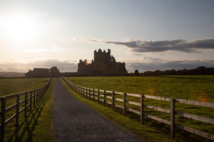
Dunbrody-1250

Dunbrody Abbey

It is a Cistercian Abbey dating from 1170, which prospered until the suppression of  the monasteries in 1536.  The ruin was left to the State in 1911.  I would have liked to have gone inside, apparently it has one of the longest naves in the country.   The monks here in the 14th century were pretty feisty, and it appears were often in dispute with their fellow Cistercians at nearby but much grander Tintern Abbey.  I will be seeing that tomorow.  But even from the outside I was having fun exploring the photographic possibilities that happen when evining light and a ruined abbey combine.  Here are a few of the photos I took that I post without comment.

Just a couple of miles further south is the seaside village of Duncrannon.  Protected since the 5th century by a Fort of some description, and even before that by a Promontory Fort that sits on the headland above the Quay.  The only way to see it is with a tour and it was way too late for that so  I had to be satisfied with viewing it from the wharf.  And Duncrannon Fort is what is known as a Star Fort, built in that shape to maximise the coverage and angles for canons.  Built in 1587 by Queen Elizabeth I to protect against the Spanish Armada, it saw much more local action during the Irish Confederate Wars of 1645 and then withstood an attack from Oliver Cromwell in 1649.  A lighthouse was built there in 1774.  During the 1798 Rebellion the United Irishmen failed to capture it and it became a safe house for fleeing loyalists and a prison and site of execution for rebels.  The song the Croppy Boy tells one such story.  Staying in the control of the British Army it was burnt down in 1922.  Now it is a museum.  It looked truly formidable sitting high on the cliffs above the ocean.

Duncrannon-

Duncrannon Fort from the water

Duncrannon-1260

Duncrannon Fort another view

Duncrannon-1254

Entrance to Duncrannon Fort

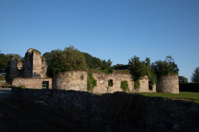
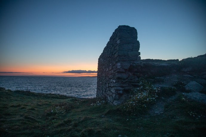
It was now after 7pm with less than an hour to sunrise and finally within reach of my goal.  But I couldn’t resist one more stop.  The village of Templetown, which may have been a village once but is now just a roadside bar and restaurant (but a popular one it would seem).  Across the road is a the Templetown Church ruin.    This was the base for the Knights Templars, a military religious order founded in Jerusalem to protect the Holy Land, who set up here in 1172, giving the name to the locality.  The Templars however disbanded in 1307 and their lands were given to their great rivals, another military order, the Knights Hospitallers.  They built this church and its adjacent fortified tower.  It is in wonderful condition, just missing its roof, and is surrounded by a small graveyard.  It looked spectacular and glowed golden against a vivid blue evening sky. I’ll have reason to talk about these fellas again.

Templars-1314

Templetown Church

Templars-1319

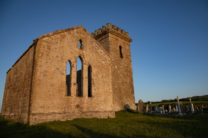
Templetown Church and graveyard

Templars-1328

Templetown Church

Templars-1306

Graveyard at Templetown Church

Paradoxically, with light running out, the next stop was definitely Hook Head Lighthouse.  I could see it in the distance and at the first opportunity I pulled off the road to photograph it.  The lighthouse is not the prettiest in Ireland, with its chunky disproportionate base, but it is iconic and it is the oldest and is spectacularly located (I guess most of them are).

Hook 2-1335

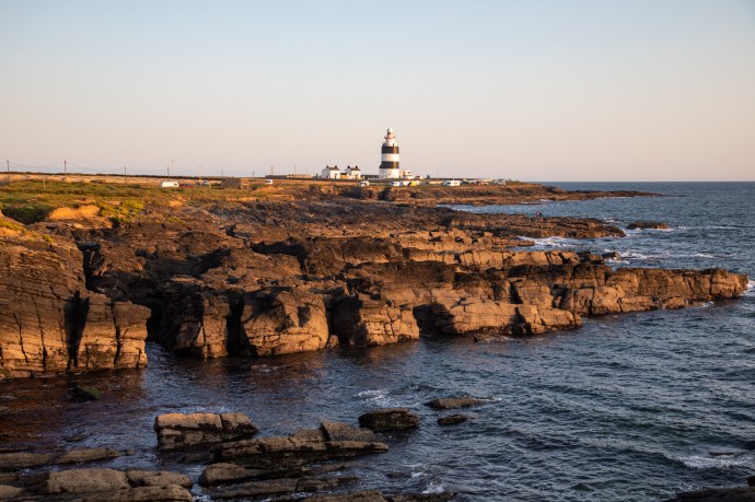
A distant view of Hook Head Lighthouse

It was built by William Marshall, who had a few strings in his bow, so to speak.  He was Strongbow’s successor (get it?) as Lord of Leinster, and had built a port at New Ross, which was 30 km up the river.  Told you I’d come back to the Templars; well Marshall was also a Knights Templar (he was known as the Greatest Knight).  The light was erected at the beginning of the 13th century and it was the monks at Templetown who became the first keepers.  They looked after the lighthouse tower until 1641 when dedicated lighthouse keepers took over until it was automated in 1996.  It is the oldest operating lighthouse in the world.

Hook 2-1357

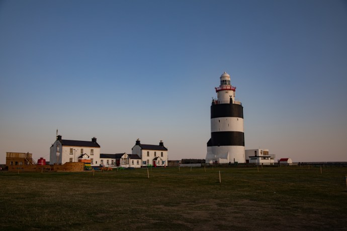
Hook Lighthouse and the old Keepers’ cottages, now a visitor centre.

Hook 2-

A view from the other side with the sun setting behind Hook Head lighthouse

Hook 2-1369

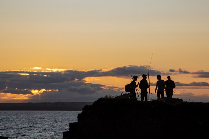
The lads are off for a fish.

That’s something to ponder on – a guiding light for 800 years. I can’t leave though without mentioning the  expression ‘by hook or by crook’.  One theory (and it is only one of a number) is that the expression came from Oliver Cromwell who had to make the decision whether they would sail up the Barrow on the Wexford side (by Hook) or by Crooke (a village on the Waterford side).  Only problem is there is a reference to the expression in a Middle English tract dated 1387, nearly 300 years before Cromwell. Wherever the expression came from I got there by hook or by crook and I became immediately hooked on the place.

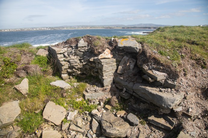
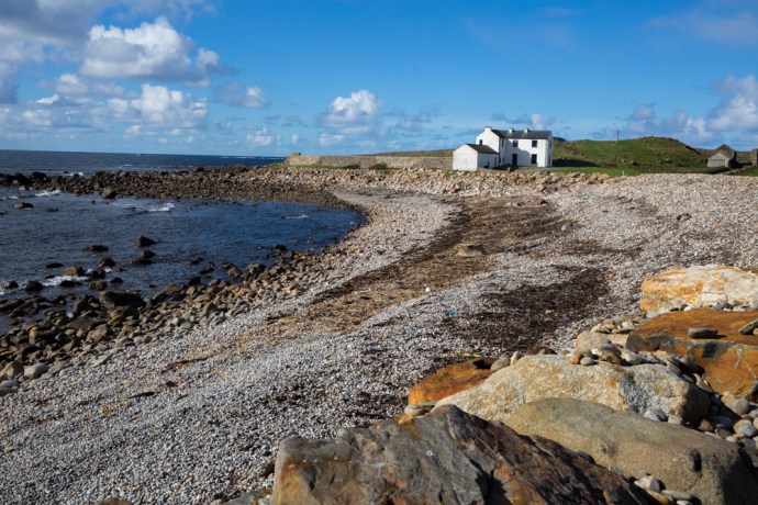
As darkness descended I looked at the collection of campervans parked on the clifftop at the base of the lighthouse, with just a hint of envy.  I searched for a spot to park up, claiming my spot right on the cliff edge next to an old limekiln and looking across to Passage East in Waterford on the other side of the Barrow.  I wouldn’t say I had the best night’s sleep but was well satisfied with an exhausting but rewarding day of travel.

Hook 2-1495

The view from my five star accommodation at Hook Head.

And as a bonus from my vantage point in the back of the car,  I watched the rising of the crescent moon and photographed the Milky Way, managing to catch a couple of shooting stars.  Where else would you want to be.

Hook Head sky night-1586

The Rising of the Moon

Hook Head sky night-1657

The Milky Way.  There are two shooting stars if you look closely

Well that’s Day 1 of this four day journey.  It’s long I know and thank you for sticking with me to the end.  Stay tuned for Day 2 which will take me north through Waterford towards Carlow.

Categories: My Journey, Real Ireland | Tags: , , , , , , , , , , , , , , , , , , , , , , , , , , , , , , | Leave a comment

The Puck Fair, Co Kerry. A 400-year old tradition.

Some institutions in Ireland die hard.  One is the Puck Fair.  Held annually in Killorglin in Co Kerry in August, it is surely one of the country’s longest running public events.  As with many of these things though, the written record is scant and it is not clear exactly how old it is.  There is a reference in 1613 to a local landlord, Jenkins Conway, collecting a tax from every animal sold at the ‘August Fair’ and even earlier there is a record from 1603 of King James I granting a charter to the existing fair in Killorglin.  So let’s just say it is well over 400 years old.

puck-6827

The main street of Killorglin is choked for the Puck Fair

Puck derives from the Irish Phoic, meaning He-goat.  Again, when the fair became associated with the goat is also shrouded in mystery.  The story I like tells how in 1808 the British Parliament made it unlawful in Ireland to levy tolls on cattle, horse or sheep fairs.  The landlord of the time lost his income and on the advice of then budding lawyer Daniel O’Connell (yes, that Daniel O’Connor), proclaimed it a ‘goat fair’ and charged his tolls as usual believing it was not covered.  To prove it was indeed a goat fair a Phoic was hoisted on a stage and proclaimed King Puck.

Whatever the truth, a male wild goat is still today crowned King and hoisted in a cage up a tower where he remains for three days before being released back into the wild.  The crowning of the goat though, I have to say, was a disappointment. Conducted on a stage under the tower, with its steel barrier that restricted vision, the goat was held by two burly yellow-coats and surrounded by photographers.  A young schoolgirl, the ‘Queen of the Fair’, placed the crown on its head.  Well, I think that’s what happened.  It was really just set up for the publicity shots, as the audience could see nothing.  Placed in the cage the goat was then hoisted up for all to see, its crown a little shakily slipping below its horns.

puck-7311

Behind that phalanx there is a goat getting crowned

puck-7354

The King of the Fair is hoisted up the tower

puck-7374

King Puck

The fair brings out the crowds for a great day out.  There is a horse fair in a nearby field, with all the usual horse-trading that happens.  I happily spent an hour wandering here clicking away.  There was plenty to keep me enthused and bemused.

puck-6811

The horse fair is held in a field adjacent to a ruined church and graveyard

puck-6774

Now that’s style

puck-6756

puck-6733

Like father like son

puck-6714

You have been warned.

puck-6770

The cheapest pee in town.  Just a half a cent!

There are rides, a parade and plenty of characters to fill the pubs and the streets. Every vantage point was taken.  The bright sunshine, when I visited in 2015, provided an opportunity for the colleens  to strut the summer fashions. I love the way traditional music is never far away from an Irish event, with entertainment on stage and in teh nearby pubs, dancing in the street or a brush dance in a pub.

puck-6866

The long and the short of it.

puck-7227

A great vantage point

puck-6838

Even manequins are keen to strut their stuff

puck-6927

Dancing in the streets

IMG_6852

Well known piper, Brendan McCreanor, from Co Louth entertains the crowd

puck-7032

puck-7084

Swept away by a brush dance

puck-6764

A chance to dress up

puck-7004

A chance to dress up II

puck-7422

Defying gravity

The Puck Fair is always held on 10, 11 and 12th August so mark it in your calendar.

Categories: My Journey, Real Ireland | Tags: , , , , , , , , , , , | Leave a comment

Ireland. A Feast of Festivals 2019

IG3C0106

Visiting an Irish Music Festival should be on the must-do list for any visitor to Ireland.  It is not easy however to find information on these, especially the smaller ones.  I am often asked by my friends in the blogosphere what is on and when during their proposed visit.  I’m happy to help where I can but I thought a list might be useful to anyone planning a trip.  On researching this I found a number of sites where festivals are listed but they are incomplete or not up to date.  I am sure I too have left some out and I don’t have dates for everything, partcularly beyond August 2019.  If you are aware of a festival that I’ve missed or have dates let me know and I’ll add it.

Do try and incorporate a festival on your next trip;  you’ll be made very welcome. If you do want to visit a festival please don’t rely on the dates here. Some are subject to change.  You should check with their website.

Festival Location Start Finish
Shannonside Winter Music Festival Six Mile Bridge, Clare 17 Jan 19 21 Jan 19
TradFest Temple Bar

Ballincollig Music Festival

Dublin

Ballincollig, Cork

23 Jan 19

23 Jan 19

27 Jan 19

27 Jan 19

IMBOLC International Music Festival Derry 15 Jan 19 10 Feb 19
Packie Duignan weekend Drumshanbo, Leitrim 25 Jan 19 27 Jan 19
Feile na Tana

Rosslare song gathering

Carlingford, Louth

Rosslare,

1 Feb 19

1 Feb 19

3 Feb 19

3 Feb 19

Concertina Cruinniú Miltown Malbay, Clare 15 Feb 19 17 Feb 19
Scoil Cheoil an Earraigh Ballyferriter, Kerry 20 Feb 19 24 Feb 19
Russell Memorial Weekend Doolin, Clare 21 Feb 19 24 Feb 19
The Gathering Traditional Festival Killarney, Kerry 27 Feb 19 3 Mar 19
Mount Leinster Traditional Music Festival Borris, Carlow February?
Tionól Niocláis Tóibín An Rinn, Waterford 8 Feb 19 10 Feb 19
Éigse an Spidéil Spiddal, Galway 10 Feb 19 14 Feb 19
Corofin Traditional Festival Corofin, Clare 27 Feb 19 3 Mar 19
Aran Celtic Music Festival Inis Mor, Galway 8 Mar 19 11 Mar 19
NYAH Traditional Music Festival Cavan 15 Mar 19 18 Mar 19
Kilkenny Tradfest Kilkenny 14 Mar 19 19 Mar 19
Ceardlann Earraigh Celbridge, Kildare ?? Mar 19 ?? Mar 19
Inishowen Singing Festival Donegal 22 Mar 19 25 Mar 19
Blossom Harp Festival

Tullamore Tradfest

Tuamgraney, Clare

Tullamore, Offaly

12 Apr 19

12 Apr 19

14 Apr 19

14 Apr 19

Feile Patrick Byrne Carrickmacross, Monaghan 12 Apr 19 14 Apr 19
Maurice O’Keefe Weekend Kiskeam, Cork ?? Mar 19
Carlow Pan Celtic Festival Carlow 16 Apr 18 22 Apr 18
Clifden Trad Fest Clifden, Galway 11 Apr 19 14 Apr 19
Cruinniú na bhFliúit Flute Meeting (registrations closed) Ballyvourney, Cork 24 Apr 19 27 Apr 19
Consairtin

Leitrim Dance Week

Ennis, Clare

Carrick on Shannon

25 Apr 19

22 Apr 19

28 Apr 19

28 Apr 19

Ballydehob Traditional Music Festival Ballydehob, Cork 12 Apr 19 14 Apr 19
Kilfenora Music Festival

Ulster song gathering

Kilfenora Clare

Omagh,

26 Apr 19

26 Apr 19

29 Apr 19

27 Apr 19

Feile Neidin, Kenmare Irish Music Festival

Ceol na nGlinnti

Kenmare, Kerry

Antrim

April?

April?

Fleadh nagCuach (Cuckoo Fleadh) Kinvara, Galway 3 May 19 6 May 19
Joe Heaney Festival Carna, Galway ? May ? May
Cup of Tae Festival Ardara, Donegal ? May ? May
Feile Chois Cuain Louisburgh, Mayo 3 May 19 6 May 19
Carrigaholt Oyster & Trad Festival Carrigaholt, Clare 3 May 19 5 May 19
Cos Cos Sean Nos Festival Drumcliffe, Sligo 6 May 19 12 May 19
Fiddle Fair


Fleadh na Deise. Waterford Traditional Music Festival

Baltimore, Cork


Kilmacthomas, Co Waterford


9 May 19


17 May 19


12 May 19


19 May 19


Feile Chnoc na Gaoithe, Tulla Trad Music Festival Tulla, Clare 17 May 19 19 May 19
Skerries Traditional Music Weekend Skerries, Dublin ? May 18 ? May 18
World Fiddle Day Scartaglin, Kerry 18 May 19
World Fiddle Day Glenties, Donegal 18 May 19
Fleadh Nua Ennis, Clare 19 May 19 27 May 19
Michael Dwyer Festival


John McKenna Music Festival

Allihies, Cork


Drumkeeran, Co Leitrim

7 Jun 19


7 Jun 19

9 Jun 19


9 Jun 19

Doolin Folk Festival

Ballydehob song gathering

Doolin, Clare

Ballydehob, Cork

14 Jun 19

14 Jun 19

16 Jun 19

16

Con Curtin Festival Brosna, Kerry ?? Jun 19 ?? Jun 19
Jim Dowling Uilleann Pipe and Trad Festival Glengarriff, Cork 21 Jun 19 23 Jun 19
Craiceann Summer School Innis Oir, Galway 24 Jun 19 28 Jun 19
Blas International Summer School Limerick 24 Jun 19 5 Jul 19
Cross Traditional Music Weekend Cross, Clare ?? Jun 19 ?? Jul 19
An Chúirt Chruitireachta (International Harp Festival) Termonfechin, Louth 30 Jun 19 5 Jul 19
Feile Brian Boru Killaloe/Ballina, Clare, Tipperary 3 Jul 19 7 Jul 19
Féile Traidphicnic Spiddal, Galway 5 Jul 19 7 Jul 19
Scoil Samraidh Willie Clancy Miltown Malbay, Clare 6 Jul 19 14 Jul 19
Ceol na Coille Summer School Letterkenny, Donegal 8 Jul 19 12 Jul 19
South Sligo Summer School Tubbercurry, Sligo 14 Jul 19 20 Jul 19
Fleadh Cheoil Na Mumhan (Munster Fleadh) Ennis, Clare 14 Jul 19 22 Jul 19
Ceili at the Crossroads Festival Clarecastle, Clare ?? Jul 19 ?? Jul 19
Joe Mooney Summer School Drumshanbo, Leitrim 20 Jul 19 27 Jul 19
Fiddler’s Green Festival Rostrevor, Down 21 Jul 19 28 Jul 19
Meitheal Summer School Ennis, Clare 22 Jul 19 27 Jul 19
Scoil Acla Summer School Achill Island, Mayo 27 Jul 19 3 Aug 19
Donegal Fiddle Summer School Glencolmcille, Donegal 29 Jul 19 2 Aug 19
Belfast Summer School of Traditional Music Belfast 27 Jul 19 3 Aug 19
Sliabh Luachra Summer School Rockchapel, Cork July?
Laois Trad Summer School Portlaoise, Laois July?
Phil Murphy Weekend Carrig-on-Bannow, Wexford July?
Kilrush Traditional Music and Set Dancing Festival Kilrush, Clare 31 Jul 19 5 Aug 19
Sean McCarthy Weekend Festival Finuge, Kerry 1 Aug 19 5 Aug 19
James Morrison Traditional Music Festival Sligo ?? Aug 19 ?? Aug 19
O’Carolan Harp Festival Keadu, Roscommon 2 Aug 19 7 Aug 19
Feakle International Traditional Music Festival Feakle Clare 7 Aug 19 12 Aug 19
Scully’s Trad Fest Newmarket, Cork ?? Aug 19 ?? Aug 19
Fleadh Cheoil na hEireann Drogheda, Louth 11 Aug 19 18 Aug 19
Feile Ceol Na Locha Tourmakeedy, Mayo ?? Aug 19 ?? Aug 19
Masters of Tradition Bantry, Cork 21 Aug 19 25 Aug 19
Crotty Galvin Traditional Music Weekend Moyasta, Clare ?? Aug 19 ?? Aug 19
Ballyshannon Folk and Traditional Music Festival Ballyshannon, Donegal 2 Aug 19 5 Aug 19
Seachtain Ceoil Chois Fharraige Spiddal, Galway August?
Fingal Fleadh and Fair, Swords Castle, Dublin ?? August
Gig’n the Bann Portglenone, Antrim ?? Sep
Johnny Doherty Music & Dance Festival Ardara, Donegal 20 Sep 19 22 Sep 19
Ceol Na gCruach The Glen Tavern, Donegal Sep?
Dingle Tradfest Dingle, Kerry Sep?
Tuam Trad Festival Tuam, Galway Sep?
Gerry Whelan Memorial Weekend Cootehill, Cavan Sep?
Feile Cheoil Larry Reynolds Ballinasloe, Galway Sep?
Frank Harte Festival Dublin Sep?
Music Under the Mountains Wicklow Sep?
Cork Folk Festival Cork, Cork Sep?
Garry McMahon traditional singing festival

O’Carolan Harp Festival

Abbeyfeale.  Limerick

Nobber, Meath

18 Oct

??Oct

20 Oct


Glenties Fiddlers Weekend Glenties, Donegal ?? Oct
Ed Reavy Traditional Music Festival Cavan ?? Oct
Foxford Traditional Weekend Foxford, Mayo ?? Oct
Sligo Live Folk Roots and Indie Festival Sligo ?? Oct
Cooley Collins Festival Gort, Galway ?? Oct
Willie Keane weekend Doonbeg, Clare ?? Oct
Feile Strokestown Strokestown, Roscommon ?? Oct
Féile Chruite Achill Harp Fest Achill Island, Mayo 25 Oct 19 28 Oct 19
Scoil Cheoil na Botha Scotstown, Monaghan ??Oct
Patrick O’ Keeffe Traditional Music Festival Castleisland, Kerry 25 Oct 19 28 Oct 19
Ennis Trad Fest Ennis, Clare 7 Nov 19 11 Nov 19
William Kennedy Piping Festival Armagh ?? Nov
Drogheda Traditional Music Weekend Drogheda, Louth ?? Nov
Éigse Dhiarmuid Uí Shúilleabháin Ballyvourney, Cork ?? Dec
Scoil Gheimhridh Ghaoth Dobhair Gweedore, Donegal ?? Dec
Trá Buí /Pearse Holmes memorial Traditional Music Weekend. Dohooma, Mayo ?? Dec


Categories: Festivals, Trad Irish Music | Tags: , , , , , , , , , , , | 2 Comments

The Colorado Rockies 7. America’s Mountain. Pike’s Peak.

Pikes Peak

There are 54 peaks in the Colorado Rockies that are over 14,000 ft (4,267m). Keep in mind that the highest mountain in Australia is 7,228 ft!) There are however only two that you can drive up. Pikes Peak is one of these.  At 14,115 ft it is still only the 53rd highest mountain in North America. Nevertheless it dominates the landscape of this part of the Front Range. If you have read my last post on the Garden of the Gods you would have seen it in the distance in many of the photos.

It is also known somewhat cheesily as ‘America’s Mountain’, In 1893, Katherine Lee Bates wrote the song “America the Beautiful” after having admired the view from the top of Pikes Peak.

IG3C0650-Pano

The snow dusted Pikes Peak towering over the forest on the climb up the mountain

A 19 mile long toll road takes you off the US24 allowing you to drive to the top. Well not quite to the top this time. They were doing extensive rebuilding of the facilities so the last three miles were in a shuttle bus.  I loved the way you were given the choice to join the bus earlier if you were uncomfortable with the drive. And if you are not used to mountain roads, well it is scary. You shouldn’t underestimate the drive.  It requires a lot of concentration.  It is two lane but there are a lot of switchbacks, steep grades and with no barriers preventing drops of thousands of feet to the valley floor. And for some reason they seem to drive on the wrong side of the road.

IG3C0881

Hairpin bends on the way up the mountain.

The driver of your shuttle will probably point out the spot at Devil’s Playground, where Jeremy Foley went over the edge during the 2012 Pikes Peak Hill Climb (incredibly he and his navigator survived).

IG3C0870

The Devil’s Playground.  Near the top of the mountain.  The bollards are where rally driver Jeremy Foley left the road in 2012.  He survived unharmed.

The $15 toll will take you on an awesomely beautiful journey through different worlds with ever-changing landscapes. Firstly pine and fir forests and the calm waters of the fishing paradise, Crystal Lake.

IG3C0653

A view of the Peak through the forest

IG3C0611

Crystal Lake.  A reservoir for Colorado Springs.

IG3C0624

An idyllic fishing spot

Then through aspen groves just starting to turn and spruce forests and over the tree line to the wildness of the alpine zone and tundra with piles of bare burnt red-brown granite boulders.

IG3C0688

Leaving the Bus Station in the Shuttle near the 16 Mile point

IG3C0695

Above the tree line.  Alpine tundra and granite

IG3C0708

Granite tors covered with the previous night’s snowfall

IG3C0723IG3C0735IG3C0739

And the photo gods were hard at work as we had a snowfall the night before and plenty of blue sky and as we climbed the mountain some low cloud to add texture and interest to the images. I was in heaven.

IG3C0857IG3C0851IG3C0834IG3C0786

It was a tad cold at the top and I have to say not being used to altitude sickness, I felt all the classic symptoms, fatigue, breathlessness and headache. (same symptoms as after an all night trad session! just kidding).   None of this detracted from the thrill of being at the top of the world. At least this little part of it.

IG3C0791

The Summit

IG3C0800-Pano

The view from the Summit

That malady disappeared pretty quickly once the oxygen levels returned to normal on the descent. And anyway there were enough distractions as the descent gives another perspective as you slowly edge down the mountain in first or second gear.  In the distance was the Cripple Creek and Victor mines one of the largest gold mines in America.

IG3C0824

A view to the south towards the Cripple Creek and Victor Gold Mines

IG3C0833

Cripple Creek Mine

I was relieved and very satisfied to reach the bottom after a remarkable drive.  Well worth the $15 toll.  America the Beautiful.

Categories: America, My Journey | Tags: , , , , , , , , , , , , , , , , , , , | Leave a comment

The stunning beauty of Harry Clarke’s windows. St Barrahane’s, Castletownshend, Cork.

Eight kilometers from Skibbereen in West Cork is the village of Castletownshend, the historic seat of the Townshend family.   St Barrahane’s Church, built in 1827, sits on a hill above the village. It is accessed by 52 steps. One for each Sunday of the year. It is an elegant building with many original interesting architectural features and some fine detailing, both internal and external, including timber paneling and an organ gallery.

IG3C2752

St Barrahane’s Church

IG3C2660

The last 13 of the 52 steps to the church

IG3C2664

Simple and elegant interior

IG3C2722

The organ gallery

Of greatest interest though to visitors is the addition in the early 20th century of six magnificent stained glass windows.

Three of these are by Harry Clarke, a book illustrator and Ireland’s most famous stained glass artist, who died in 1931, and three are by Powells of London. It is not hard to pick those by Clarke.  They are characterised by beautiful, finely crafted, elongate figures and his use of deep rich colours. the wall to the right of the altar has three windows with the Clarke window, on the right, being quite distinct and obvious.

IG3C2734

The Harry Clarke window is on the right.

IG3C2665

The Louis and Martin window by Harry Clarke

This window depicts French Saints Louis (who was Louis IX, King of Spain) and Martin and was commissioned in memory of a Colonel Coghill in 1921. A window of two lights, the first light depicting St. Louis who was an ancestor of the Colonel. The figures above his head represent the poor who he often fed at his table. The first of the tracery lights depicts a ship in which King Louis sailed to the east to fight the infidels. The second and third tracery lights depict two angels who offer protection to both saints. The fourth tracery light shows St. Martin’s flaming sword, denoting his patronage of soldiers,  The second light depicts the meeting between Saint Martin of Tours, dressed as a soldier’s garb, and a beggar who asks him for clothing.  Again the imagery is imaginative, stunningly crafted and in glorious deep colours.

IG3C2668

Detail of St Louis

The largest window, known as the The Nativity window, was commissioned in 1917 in memory of the Somerville family.  This window has three lights, with separate depictions of the shepherds paying homage to the Christ child, the holy family and the magi but with linking elements such as Mary’s dress and the crib that create a unified picture. They are exquisitely decorated in shades of blue, pink, green, red, purple, magenta and gold. The tracery lights depicts three saints, Brigid, Fachtna and Barrahan in gorgeous detail.

IG3C2705

The Nativity window

IG3C2709

Detail of the Nativity window

IG3C2713

The three Saints in the Nativity window

When you look at these windows from outside the church, you can have no expectation of how stunning the images are when back lit.

IG3C2751

The Nativity window from the outside

If you a visiting West Cork you really must take a peek. Or look for Clarke windows in Dublin and many other locations in Ireland and England.

He completed over 130 windows.  You can find where they are here  https://en.wikipedia.org/wiki/Harry_Clarke

Categories: My Journey, Real Ireland | Tags: , , , , , , , , , , , , , , | Leave a comment

The Colorado Rockies 4. Independence – a Ghost Town.

Independence ghost town

In my last blog on my road trip through the Colorado Rockies, I talked about Independence Pass and its close connection with the discovery of gold. Gold in this part of Colorado was discovered on 4th July 1879 at Roaring Fork River about four miles from the top of the Independence Pass and a town soon sprung upon the banks of the river and in the shadow of Mt Independence. It started as a tent city and one year later there were 300 people living in the camp.  The following year a single company, Farwell Mining Company, had acquired the leading mines such as Independence No 1, 2 and 3, Last Dollar, Legal Tender, Mammoth, Mount Hope, Champion, Sheba, Friday, and Dolly Varden.

IG3C1227-Pano-2

The ghost town of Independence at the foot of Mt Independence in the valley of the Roaring Fork River

Various competing interests battled over the name of the town.  During its short life it was variously known as Belden, Chipeta, Sidney, Farwell, Sparkhill and in its fading days optimistically Mammoth City and Mount Hope.  Ironically though and for obvious reasons, it was widely known as Independence though there was never a post office of that name.

By summer of 1881 there were 500 people and many permanent buildings including grocery stores, boarding houses and three saloons. It reached its peak in 1882 when there were 90 buildings containing 40 businesses and a population of 1,500.

As with most mining booms, the bust followed quickly when the gold ran out and by 1888 there were only 100 citizens eking out an existence at an elevation of nearly 11,000 feet and under a blanket of snow from October to the end of May.  The worst storm in Colorado’s history hit in 1899 and those residents still there were completely cut off for months. Running out of food, they dismantled their houses to make skis and 75 residents skied their way to Aspen. Only one resident remained after this. Jack Williams was caretaker of the stamper battery and treatment plant.  In 1912 Jack finally left and that was the end of the town of Belden-Independence-Chipeta-Sidney-Farewell-Sparkhill-Mammoth City-Mount Hope.

IG3C1276

A restored miner’s cabin now used as a summer residence.

IG3C1279IG3C1289

Incredibly a number of buildings have survived to varying degrees in this spectacular location. Some remain relatively intact and have been restored and some are piles of timber or just depressions in the ground. Ted Ackerman’s Hotel was one of five during its hey-day. Little remains of this establishment where miners could find a room for $2 a day.

IG3C1239

Ruins of Ted Ackerman’s Hotel

A general store stands proud, restored in the 1980s and a remarkable testament to the courage of these men (and a few women) and the lure of gold.

IG3C1261

Restored general store

As a geologist with a strong interest in the company history and social history of gold mining in my home country I have seen many Australian ‘ghost towns’ from the gold rush days. They were much more transient and rarely does any structure survive as here. Australians built with hessian and stone and corrugated iron, rather than timber, which is so abundant here, and material was transported to the next town following abandonment.  You’d have to say that heat was more of a problem than cold generally.  Its hard not to be impressed though by the simplicity of construction of the log cabin and its durability.  140 years later the v-notch joints still hold the structures together.


Just downstream from the town is the timber framework of a large stamper battery and on the slopes above there is a bit more mine infrastructure, the head of a mine shaft and a patch of Aspen covering what was obviously a spoil dump.  I would love to have had time to explore more.

IG3C1319

Remains of a  large stamper battery.  The treatment plant would have been on the flat area below.

IG3C1316

An old mine site.  The mound in the distance was the head of a shaft and the patch of aspen covers a spoil dump.

Preservation of these sites is essential.  They are one of the few tangible links to a hugely important part of the development of countries such as USA and Australia.  As in Australia, mining was responsible for opening up large tracts of the country and for the beginnings of many towns, some gone like Independence, some still surviving like Aspen, Leadville or Cañon City.  I’ll come back to this in a later blog.

Categories: America | Tags: , , , , , , , , , , , , , , , , , | 2 Comments

Of Magic Mushrooms and Ancient Ireland

There are a number of major ancient Royal Sites in Ireland but the four important ones were the seats of the four provinces. These are Cashel for Munster, Navan Fort for Ulster, Dun Ailinne for Leinster and in Co Roscommon, Rathcroghan for Connaught. . There was also Tara with its special status as the seat of the High King.  There is evidence of activity at these sites from deep in the Stone Age, through the Bronze Age to the height of power in the Iron Age and into Medieval Christian times.

I visited Rathcroghan recently. Before the coming of Christianity this was the religious, ceremonial and political heart of the Kingdom of Connaught. There is a wealth of archaeology scattered over 6 square kilometres with 240 sites recorded of which 60 are listed. I visited the ring barrow mound of Rathbeg, probably continuously used over this entire period, the great mound at Rathcrogan, the site of major royal celebrations and the medieval raised ring fort of Rathmore. Not easy to photograph from the ground, where they appear as grassy mounds but their sheer size and concentration are impressive.

IG3C5477

The ring barrow fort at Rathbeg

IG3C5541

The ceremonial mound at Rathcroggan

IG3C5553

The ring fort at Rathmore

But I wanted to talk about something else.

I met a fellow at Rathbeg. I’ll call him Patrick.  I’d watched him slowly walking the fields around the mound, head down searching. Is he looking for stone axes or ancient relics?

IG3C5503

Patrick searching the fields around Rathbeg

We had a chat and the answer was not what I expected. He was searching for psilocybin better known as magic mushrooms. Patrick had a little bag full after an hour of searching. He told me he takes one dried every four days to manage his headaches and migraines and has been doing so for sixteen years. We searched together for a while but the slender bulbous fungi proved elusive.

IG3C5497

A magic mushroom pokes through the grass

IG3C5489

Part of Patrick’s harvest

IG3C5493

Detail of magic mushrooms

Magic mushrooms are among the oldest recreational drugs that human beings have ever used. They are believed to have been used for over 5,000 years down to the pop culture of today.

Hard evidence of its use in ancient Ireland is scant but this is hardly surprising. Indirect evidence however suggests widespread use in neolithic times. The rock art in Knowth and Newgrange is thought by some archaeologists to reflect the psychedelic state of the artist. Many traditional Irish tales seem to disguise the psychedelic experience in metaphor. For example hazelnuts accidentally ingested by Fionn mac Cumhaill, which gave him wisdom and pleasure, are though by some to be liberty cap or amanita muscaria mushrooms. Old stories of St. Brendan, refer to .him finding “fruits” – some poisonous, some euphoric that staved off hunger. Visions of faeries are so strongly associated with mushrooms that the Gaelic slang for faeries and mushrooms is the same: ‘pookies’. A magic mushroom trip has you “away with the faeries.” Or “off with the pixies.”

But what I found really interesting was Patrick’s comment that he has found the best place to find these mushrooms was at Ancient Sites. His idea was that it was the reason the sites were there and that mushrooms formed a fundamental part of their religious, cultural and social fabric.

An intriguing thought.  I left him to his searching.

Categories: My Journey, Real Ireland | Tags: , , , , , , , , , , , , , , | 1 Comment

An Ancient Coast and 5,000 years of Irish history. Maghery in Beautiful Donegal.

One of the things I love about touring in Ireland is that you find so much to enjoy in the most unheralded and remote corner of of the country.  You don’t need to join the throngs of visitors kissing stones, ticking boxes and visiting interpretive centres to enjoy the ‘real’ Ireland.

Take the village of Maghery in the the area know as The Rosses near Dungloe in west Donegal.

What drew me there was a sunny Donegal Saturdayin late autumn and a vague knowledge of some sea arches at nearby Crohy Point, a spot favoured by photographers.

IG3C3538

Clohy Sea Arches

But I found far more.

Yes there was the Bristi Stack and the Clohy Sea Arches. Unique land forms such as these are found dotted up and down the Irish coastline. It was easy enough to find the location along a scary single lane cliff road. And I mean scary; you have no choice but to rely on the other driver to be doing the right thing.

The Clohy Sea Arches are marked on GoogleMaps but not on the ground. Clearly they don’t want people stopping. There is space for two cars to park on the verge and you can’t actually see the rock formations from the road. Feeling that sense of welcome provided by a locked farm gate you climb it and follow a track that leads toward the coast and down the hill where you get your first look at the unusual triangular arch.

IG3C3600-Pano

Panoramic view of Clohy Sea Arches

IG3C3616

The Bristi Sea Stack

Nestled in a small bay it is accompanied by a number of pinnacles which are the remains of similar collapsed arches. There is another quite different arch attached to the mainland at the other end of the bay where the rocks are dragged into near vertical by a fault which has since eroded out.

IG3C3590

Natural bridge formed by erosion of fault fill material

The Bristi stack was first climbed by professional sea stack climber Iain Miller in 2011. If you are contemplating it you need ropes, a dinghy to get there, amazing skill and a whole lot of heart.  Not for me but have a look at this video on climbing Bristi Sea Stack

Bristi-Stack

That’s Iain Miller stands on Bristi Sea Stack.  Unknown photographer. Unknown date

For more sedate pleasures I drove back to the village. Past the 1804 Signal Tower, like many others that dot dozens of remote headlands and islands along the west coast of Ireland. Built to give warning of an impending invasion by Napoleon.  This one looks to be in excellent condition. I wasn’t up to the hill walk to get there this day. Thanks be to long lenses.

IG3C3507

View in the vicinity of Maghery.  Napoleonic signal tower.

IG3C3638

Napoleonic signal tower

The village itself lies adjacent to a beautiful wide sandy strand. This Saturday it was empty except for the local equestrian group practicing their show jumping in this idyllic location. Happy horses indeed.

IG3C3988

Maghery nestled in the bay

IG3C3813

Practicing show jumping on the beach at Maghery


Hand painted signs on slate placed by the roadside led me to other points of interest. There is an impressive stone circle just north of the village.  Again you are left to your own devices; there is no marker on the ground and no directions as to how to get there.  Twenty metres in diameter and a bit overgrown but some diligent searching found this 4-5,000 year old monument. These circles are very rare in west Donegal, I believe.

IG3C4049-Pano

Termon Stone Circle

From here you get a sense of that Donegal wildness as you look to the north east across Dungloe Bay towards Mt Errigal 23 km away on the horizon.

IG3C4012

View across Dungloe Bay to Mt Errigal

Nearby is Termon House built in late 18th century and once owned by the local clergy sits on its own glorious beach. It is available as a luxury holiday rental.

IG3C4006

Adjacent to the house are some impressive walls built as work relief for those affected by the famine of 1847.  Hence ‘Famine Walls’.  Apparently the government refused to support the then landowner who ended up footing the £1,500 cost of paying his labourers 1d a day to build the wall. Beautifully constructed though they remain standing 170 years later.

IG3C4068

The afternoon was closing in and I could hear  the ringing sounds of twenty fiddles filling my head with mazurkas and schottisches so it was time to return to Glenties.  I was well satisfied with this little village that delivered a slice of Donegal’s wild coastal scenery and its human history of over 5,000 years.


Categories: Real Ireland, Wild Ireland | Tags: , , , , , , , , , , , , , , , , , , , , , , , , , , , , | Leave a comment

Blog at WordPress.com.