Posts Tagged With: Geology

The Colorado Rockies 6. The Garden of the Gods.

Garden of the Gods

IG3C0104

The main entrance to the park with Pike’s Peak in the distance.

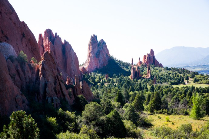
The Garden of the Gods.  What an evocative name.

A geological and scenic marvel, this public park and National Monument lies on the edge of the Front Range of the Colorado Rockies surrounded by the communities of Colorado Springs and Manitou Springs.  Indeed it is so much part of the community that the rock formations and houses coexist in many places.

IG3C8084

IG3C7968

Houses nestle among rock formations of the Garden of the Gods

Jagged irregular spires of red and white sandstone, some reaching 300 feet high, tower over the forest creating a fantastical landscape. The whole thing framed by a snow capped mountain range containing one of the highest peaks in Colorado.  The first Europeans to see this terrain proclaimed it as “a fit place for the Gods to assemble. We will call it the Garden of the Gods.”  The name stuck.

IG3C0040-Pano

Sunrise

IG3C0539

Jagged spires make for a fantastical vista mimicking the pines.

IG3C7922

Mt Cheyenne range glows at sunrise.  Taken from the front yard of my Airbnb overlooking Colorado Springs.

IG3C9977

North Gateway rock with Pike’s Peak

Of course as you can see from these images it is an incredibly beautiful place but the rocks tell a fascinating geological story that spans a billion years, with almost every geological period represented.  Stick with me.  The story begins with 1 billion year old Pikes Peak granite  intruding into the older 1.7b year old gneiss of the so-called Ancestral Rockies .

IG3C0529

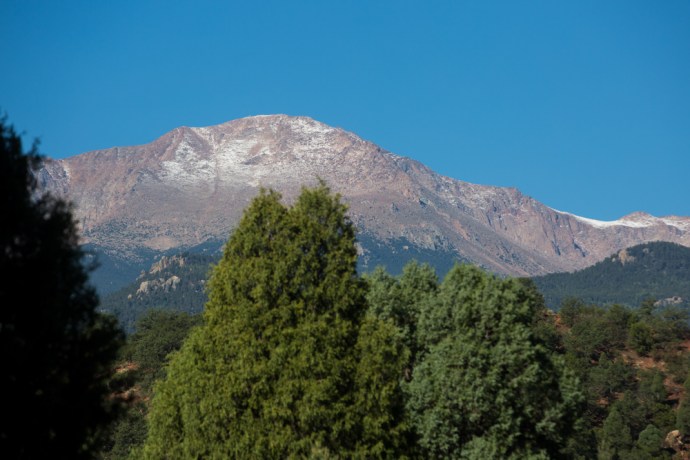
Pike’s Peak looms over the Garden of the Gods Park.  A dusting from a snowfall the previous night. The mountin is comprised of the 1 billion year old Pikes Peak Granite.

These mountains wore down progressively and around 250-300 million years ago the resulting sediment fed into a giant sea that ultimately became a  huge sandy desert. Great dunes of red sand accumulated to create the thick sedimentary rock formations known by geologists as ‘red beds’.

25 million yeas later these then flat lying sediments were covered with a great inland sea until the Jurassic, around 150 million years ago, when the climate changed again creating a rich tropical forest grazed by dinosaurs.  About 65 million years ago an intense period of mountain building began; the orogenic upheaval that built the present day Rockies.  Colossal forces created massive fault lines which stood the sediments upright.

IG3C7938

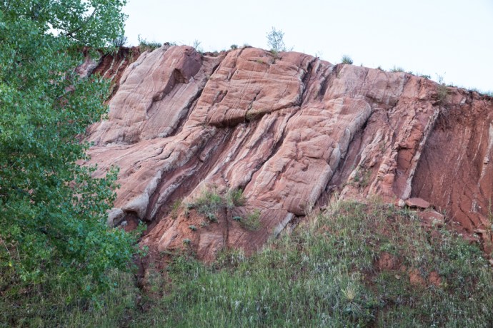
Red sandstones stood on their end by geological tectonism.  A flat lying reverse thrust fault is visible also in this cutting.

Erosion and then glaciation has selectively removed the softer rocks and left the landscape that we see today – a giant  sculpture in sandstone, conglomerate and limestone.

IG3C9880

Pike’s Peak glows as it catches the first rays of the rising sun

IG3C8059

View from the Red Rock Open Space at the Garden of the Gods.

IG3C0278

Differential erosion in the vertical exposed rocks create these stark contrasting outcrops.  Kissing Camels in the distance and White Rock.

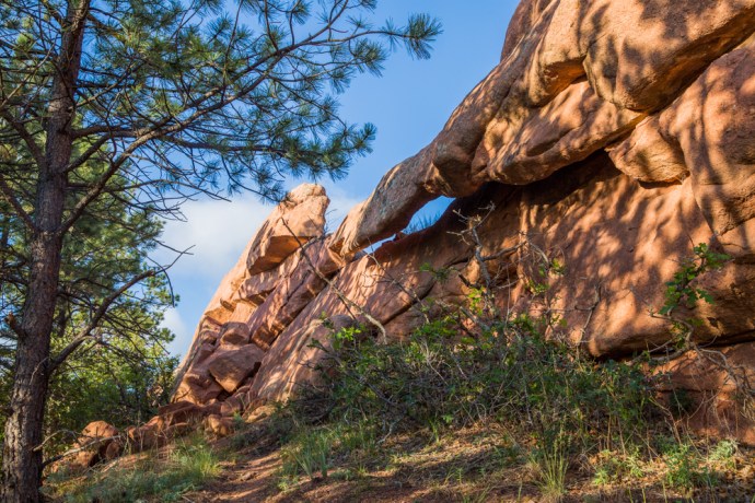
The only way to really appreciate this place is to walk through it and around it, to become part of it, taking it in from different angles and in different light.  I was up at sunrise one day when it glowed in the dawn light.  The reds are redder against the bluest of skies.  There are miles of trails to explore and there are many rewards along the way.  Unique formations have names that reflect their morphology.  Kissing Camels, The Sentinel, Cathedral Rock, White Rock.  There are natural holes, arches and the precarious Balanced Rock.

IG3C0400IG3C0332IG3C0130IG3C0454

IG3C0520

Cathedral Rock

IG3C8025

A natural hole

IG3C8040

A natural rock arch

Of course the rock formations are its most obvious and spectacular feature but it is also a mighty challenge to the most technical of rock climbers.  Unfortunately I saw evidence that this activity is not always sympathetic to the natural and geological values of the area.  For example at the Sentinel is an excellent  example of ancient ripple marks insensitively defaced by a drill hole for for a climber’s foothold.

IG3C0324

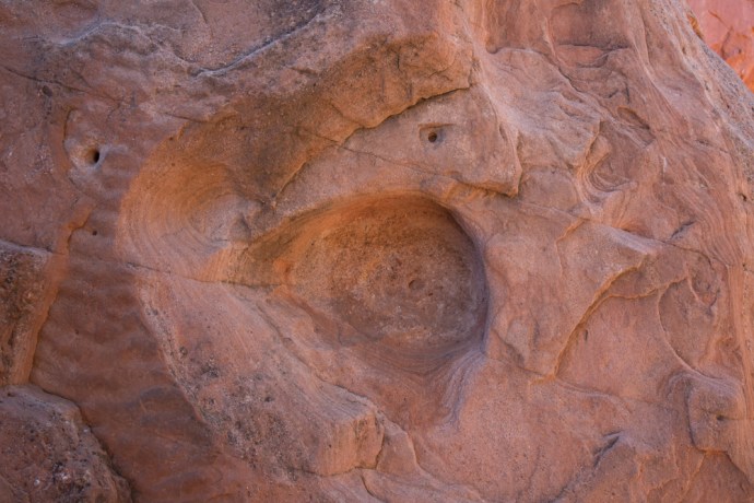
A rare exposure of ripple marks defaced by rdrill holes.

It is also a haven for wildlife.  I saw deer and a variety of birds, including what appeared to be hawks nesting high on a pinnacle.

The special nature of the place was recognised by the early landowners, most notable among them Charles Perkins, whose family, on his death in 1909, gave their land to the City on condition that it would be a free public park.  That promise has been honored for over a hundred years.

We should be grateful for the foresight of these people, who recognised something that needed to be preserved and shared so that today it is one of the most visited parks, and one of the most loved, in America today.

IG3C0077

Categories: America | Tags: , , , , , , , , , , , , , , , , | 2 Comments

Skellig Michael. Forget ‘Star Wars’. It’s more like ‘Close Encounters of the Bird Kind’.

Finally I got onto Skellig Michael after three tries over two years. The island is 12 km off the Kerry coast and to get there you need quite a bit of persistence and a lot of luck. Fortunately the monks were smiling on an unseasonably warm day in early June. In fact we were in the third week of a sunny spell like no one could remember. Day after day over 20 degrees.

I really was excited as 12 of us boarded the first ferry of the day out of Portmagee, one of 15 that have permits, Twelve of the lucky 12,000 a year to visit.  Leaving the calm, blue harbour of pretty Portmagee, its painted cottages reflected as if by a mirror, we headed towards the mystical island.

IG3C8568

Leaving the harbour at Portmagee

IG3C8565

The village of Portmagee.  Reflective calm

But first we sailed past the nearby Little Skellig, Skellig Michael’s twin rock. George Bernard Shaw said of Skelllig Michael following a visit in 1910, it was the most fantastic and impossible rock in the world”.  Like its big brother, Little Skellig is if anything more jagged and more precipitous and more impossible. As we sailed around the island constantly changing our view different faces were revealed.

IG3C8828

Little Skellig I

IG3C8833

Little Skellig II

IG3C8811

Little Skellig III.

These islands defy geological truth. The Devonian sandstone protrusions shouldn’t be there. It is easy to see how the ancients would have believed they got there by the hand of God. Jagged needles of stone, rocky barbs, thrown into the sea by an angry deity.  Piled one on the other. I can see little vegetative life. Useful to no man.

But useful to birds they are.  Little Skellig is painted white with birds and their droppings. Gannets, gannets and gannets.  Some say 50,000 of them. I can’t not think though of Monty Python and the Bookshop Sketch.  ‘Do you have Olsen’s Standard Book of British Birds? The Expurgated version. The one without the gannet.’

IG3C8720

Gannets on Little Skellig

IG3C8793

Did I mention gannets?

IG3C8785

Natural arch at the northern end of Little Skellig

This is the second largest such colony in the world. There doesn’t seem to be room for anything else as every rock ledge is crowded. A majestic sea bird, second in size only to the albatross, the sky is filled with their gliding forms as some soar effortlessly around our boat.

IG3C8777

Every surface is occupied by a gannet

IG3C8728

A gannet glides past our boat

We head to the Big Skellig.  In much more comfort I should say than the monks who arrived in their curraghs in the 7th Century, or even George Bernard Shaw who in 1904 was rowed by 10 oarsmen who took 2½ hours for the trip. As the island loomed, its jagged peaks towering over us,  to me it seemed softer than the never-occupied Little. There were patches of seductive vivid green on its slopes.

IG3C8846

As we head to the south Skellig Michael is revealed

IG3C8873

Looking back northwards towards Little Skellig

IG3C8919

Skellig Michael looms.  Approaching from the north

We tied up temporarily against a set of concrete steps and you had to time your leap with the rising and sinking of the boat. They warned us about the steps to the monastery but no mention of this.  It would be impossible to land in any kind of swell. I have heard stories of visitors getting to the island but not being able to disembark.

This was not the first place the monks landed but one of three used over the centuries and the only one used today.  This choice  historically provided the opportunity to get ashore regardless of wind direction.  Above us winds a set of steps of stone heading straight up the mountain. This path is not now used.

IG3C8907

Steps rise to the monastery from the north landing place.  Currently not used.

Instead we follow a path that snakes south, clinging to the cliff edge past nesting sea birds on sheer cliffs to the start of another set of steps that is the current route up.

IG3C9392

The access road along the eastern face of the island.  The main steps to the monastery rise up the saddle between the two peaks.

But then I see my first puffin and then another and then they are everywhere. These cute and protected birds are the stuff of legend and a reason alone to ensure your visit is in late Spring or early Summer. We all of us turn into expert wildlife photographers producing copy fit for National Geographic. It is impossible not to take a great photo.

IG3C9026

My first sighting of puffins

IG3C9104

Poser.

IG3C9154

Close Encounters of the Bird Kind.

But I am going to pass on the puffins for the moment. I will have more to say about them in another place. It’s not just puffins though. They share the rocks and crevices with many others. Guillemots clustered together with a similar upright stance on the narrowest of ledges, looking for all the world like penguins. Kittiwakes with specially designed claws that enable them to cling on to their precarious piece of rock. Razorbills with their distinctive white streaks to the eyes. Gulls, terns and others such as shearwaters that I didn’t see. An aquatic avian paradise.

IG3C9032

Guillemots and kittiwakes nesting on the cliff

IG3C9038

Kittiwakes grab their spot wherever they can

IG3C8979

Razorbills

The main purpose of any visit to this place though is to see the monastery. Not tackling the 611 steps to the stone structures atop the northern peak would be like visiting the Guinness factory and not having a pint. The journey up is spectacular but so is the reward.

IG3C9054

Visitors start the climb

IG3C9065

In the footsteps of the monks

IG3C9182

The final leg heads up from Christ’s Saddle, the area between the two peaks

It is considered the best example of an early monastery in Ireland and is of world significance. Developed between the sixth and eighth centuries it is truly remarkable for its preservation.  A series of terraces contains six ‘clochán’-type beehive cells, two oratories, stone crosses, slabs and a later medieval church.   The cells and oratories are all of dry-built corbel construction. This unique method of overlapping stones giving an igloo shape to the outer wall but more regularly rectangular inside is very efficient at keeping out wind and water and have been doing so for 1,500 years.  Other terraces housed gardens. Vegetables were believed to have been grown but their main source of food was fish, birds and eggs. The monks led a simple life of foraging and prayer and sought out remote places such as this, as the hardship and sacrifice proved their devotion, until the island was abandoned in the 12th or 13th century.

IG3C9221

IG3C9289

Rich archaeological heritage including beehive huts and a high cross

IG3C9245

Inside a beehive hut

IG3C9259

View through the window of the church

While regaining our breath, one of the OPW guides Catherine, who has been doing this for 18 years gave us the benefit of her wisdom. And cheerfully took my photo as I and countless others posed for the de rigeur ‘selfie’ shot with Little Skellig in the background. Funny how small Ireland is.  I had met Catherine at a music festival, two years ago.

IG3C9286

Proof I was there

For some monks sharing this isolation with other monks was still not enough. On the higher south peak there is an hermitage, where a monk is believed to have led a solitary life. You can’t reach it now but just getting there involve huge risk and athleticism, No steps in places just toe holds cut into the rock face. And squeezing through the notorious Eye of the Needle. In the accompanying photo you can just see the terraces across the valley near the very top of the South Peak.

IG3C9201

The South Peak.  You can just see the stone walls of the Hermitage near the peak.

IG3C9200

A close up of the terraces at the Hermitage site.

I can but wonder at the devotion and sacrifice of these people. Their zeal to be closer to God seemed almost to have given them super powers.

Our time at the top though was all too short. Conscious all the time of getting back to the boat I returned down the mountain gingerly negotiating the steps to the bottom. Just a little quicker I have to say than the way up. I surprised myself actually at how doable the climb was and though I saw many struggling I saw no one give up.

IG3C9400

The southern shore of the island.  One lighthouse is visible on the right

IG3C9407

view of the south peak and the road to the second lighthouse

IG3C9452

The main landing spot for the monks with the ancient steps up the valley

You can’t get everywhere on the island though.  The road to the lighthouses (there are two of them) is closed and they can only be seen from the ocean.  In fact on the way home our helpful skipper from Casey’s took us around the southern shore where aside from the lighthouse you can see the other landing points I mentioned.

I met Christina, a fellow Aussie, who was lucky enough to get onto the boat during her short visit to Ireland.  It was impossible not to be infected by simply being on this ‘impossible rock’.  The joy on her face was real as it was on the faces of the others that were privileged enough to get there on such a warm sunny day.

This will be a lifelong treasured memory for us all.

IG3C9345

IG3C9476


Categories: My Journey, Real Ireland, Wild Ireland | Tags: , , , , , , , , , , , , , , , , , , , , , , , | 6 Comments

Giant Steps

Giants CausewY pAnorama 1

The Giant’s Causeway is on every visitor’s must see list on the island of Ireland. For lots of different reasons. It’s a beautiful place on a beautiful coast, It has mystery and mystique. It is intriguing and enigmatic. That’s why over a million people a year visit.

It is located in Northern Ireland in a part of Antrim known as The Causeway Coast.  I have been there twice in the past year – in January 2017 in the depth of winter and in September. Both times I was gifted with marvellous weather.

For me as a geologist it was like worshipping at a holy shrine. So I thought I would put together a few of my observations from the two trips.  Apologies if this is too dry for you but you can skip the words and just look at the pictures.

So what are we talking about here?

The Causeway is part of an extensive coastline exposing thick basalt flows.  The scenery is nothing short of spectacular with sweeping bays and jagged cliffs stretching as far as the eye can see.


IG3C1241

The Causeway Coast looking west with Giant’s Causeway in the foreground.  

IG3C1248

The coastal path from the Causeway to the Chimney Tops past the Organ Pipes

IG3C1423a

View west showing Causeway and Chimney Tops in the distance.

IG3C9835

Giant’s Causeway is on the right and the Camel Rock on the left.


The Giant’s Causeway is most famous for the spectacular columns, or more correctly ‘columnar jointing’ in the basalt. The origin of the columns has historically caused all sorts of consternation. Our forebears did not believe such regular shapes could be created naturally. So if it wasn’t the work of the Almighty then it must have been Finn McCool. Hence the legend of the Irish Giant constructing the causeway to engage with his counterpart in Scotland, Fin Gall.


Giants Causeway 3

View from the clifftop down onto the Causeway.


IG3C9907IG3C9903IG3C9882

IG3C0976IG3C0961

And he left evidence didn’t he? In his haste to get back to Ireland and escape from his giant nemesis, Finn McCool lost a boot which remains to this day adjacent to the Causeway. There is a more prosaic explanation and I’ll return to this later.


IG3C1038

The Giant’s Boot


The Causeway came to the attention of Science however in the late 17th century and right through the 18th century it was the focus of intense debate as to its origin. Geological science was then in its infancy. Two intensely opposed schools of thought developed. The Vulcanists, who believed the columns were basalt solidified from lava and the Neptunists who said that all rocks including basalt were sedimentary and formed in a great ocean. The Giants Causeway was at the centre of this debate. So it is one of the most significant places in the history of the geological sciences. That debate has long since been resolved in favour of the Vulcanists

We now know, however, that the columns are caused by cooling cracks that developed at the bottom of a lava flow where it was in contact with the cooler rock beneath. As the lava continued to cool these cracks slowly propagated up creating regular, generally six-sided (though they can have from three to seven sides), columns. These regular columns are called colonnades. The hexagonal shapes are caused by the joints tending to be at 120º to each other. At the exposed tops of the flows cooling was more rapid where there was contact with air and water, so the jointing was irregular and blocky. This type of jointing is called entablature. You can see this very clearly in many places especially at the, so called, Organ Pipes


IG3C0876

Regular hexagonal columns

IG3C0947a

Columns with 4, 5, 6 or 7 sides.

IG3C1130a

Columnar jointing


IG3C1117

Spectacular columns at the Organ Pipes

If you look closer at the columns you will see that in addition to the regular vertical joints that create the columns there is also another set of sub horizontal joints which slices each column into regular segments. These were created by the release of stress during contraction within the columns.


IG3C0989

Horizontal jointing


The really intriguing thing is that when these columns break along thee horizontal joints to form the rock platforms they are in fact ont horizontal.  Usually they are either  beautifully concave or convex and the segments fit perfectly together in a ball and socket arrangement. The concave joints are easily spotted on the rock platform as they retain pools of water.


IG3C9908

IG3C9880

Detail of column surfaces.  water collects on convex surfaces


The columns make an impressive display whether on the rock platforms or in the cliffs.  There is a formation at the eastern end known as the Chimney Tops. If the illustration attached from an 1888 book is accurate, then the chimneys are considerably smaller than they were in the 19th century.   I suggest you go and see them before they disappear.


IG3C1229

Chimney Tops 2017


Chimney-Tops-Giants-Causeway

Chimney Tops 1888


It is easy to see how the Neptunists thought the basalts were of sedimentary origin.  There is a distinct layering which could be mistaken for sedimentary banding. Of course it represents different lava flows.  particularly confusing is a distinctive orange red layer in the middle of the cliff.  It is known as an Interbasaltic Formation; a laterite horizon, and is caused by the basalts below it being exposed to weathering for a considerable time before the upper series of basalt flows were deposited. It also suggest a warmer climate at the time as laterites require tropical conditions to develop. It is composed mainly of clays and is rich in iron and aluminium (most other elements were leached out) and has been mined for these ores elsewhere in Antrim.


IG3C9965

Layering in basalt flows

IG3C1232a

Interbasaltic laterite


IG3C1171

Laterite in detail


Within this laterite hori\on you can see relicts of the original basalt as paler partially weathered rock. There are also some excellent examples of preserved circular structures representing earlier spheroidal weathering within the normal basalt. This is caused by water percolating down vertical and horizontal cracks eventually creating rounded blocks. It is also known as ‘onion skin’ weathering.

Oh I forgot.  Finn’s boot.  It’s actually a glacial erratic, deposited by a retreating glacier at the end of the last Ice Age (about 10,000 years ago). Much more boring explanation.


IG3C1045

Giant’s boot.  Glacial erratic


I know I’ve gone on about the rocks but the spirit of the place is palpable.  The only word I can think of is Romance,.

IG3C9962IG3C9909

Romance and Rocks.  What a combination.


Categories: My Journey, Real Ireland | Tags: , , , , , , , , , , , , , , , , , | Leave a comment

The Torr Road Drive, Co Antrim. Lime Kilns, Game of Thrones and sublime beauty.

Travelling by car along the north coast of Antrim is spectacular to say the least. As seems to be the way of the world the drive has to have a label. So this is the Causeway Coastal Route because it features the Giant’s Causeway. I will blog on this and other places in due course because they warrant attention. But after Ballycastle, if you are heading east, the Causeway Coastal Route turns inland (away from the Coast – go figure!) towards Cushendun and Cushendall.  So most travellers miss a little pocket of Antrim that is staggeringly beautiful. This is the Torr Road which hugs the coast to Cunshendun.  Ireland is noted for its green of course but in many parts that green turns brown and red in winter.  Not here.  In this part of Antrim you seem to get the Forty Shades all year.

ig3c1463

View from the Torr Road, Antrim

ig3c1475

Green and gold.  Just add sunshine.  Torr Road.  Antrim

ig3c1607a

Green slopes that run down to the sea.  Torr Road, Antrim. That current looks pretty treacherous.  Scotland is visible on the horizon.

ig3c1616

Coastal view, Torr Road.

ig3c1670

Fences need repair whatever the weather.  Torr Road, Antrim.

Of course the road leads to Torr Head.  This is the closest point to Scotland and from here you look across to the Mull of Kintyre.  It was very cold this morning, so I resisted the temptation to climb to the top. At the top of the headland is a tower which watches over the Sruth na Maoile (Straits of Moyle), a former haunt for privateers, and acted as a signal tower, passing on messages of ship movements to Lloyds of London.  There is also a now ruined, customs station which was abandoned in 1922. Its stark ruin brings an evocative supernal element to the gorgeous views both along the coast and back towards the hinterland.  Awaiting you, at the end of this drive at Cushendun, is the gateway to the Glens of Antrim, but that’s another story.

ig3c1484

Torr Head.

ig3c1518

Ruined Customs House, Torr Head.  Antrim.

ig3c1500

Ruins of Customs House, Torr Head

ig3c1493

ig3c1576

Phone Box looking towards, Torr Head.

On my first drive along this road I went past a turn off to Murlough Bay. It was an inconspicuous sign and nothing drew my attention to it. If it hadn’t been for my B&B hosts that night at Teach an Cheol, just out of Ballycastle then I would have missed this little gem entirely. They insisted I go back there before leaving Antrim. Thank you  Micheál and Catherine.

The single lane road to Murlough Bay snakes off the Torr Road across brilliant green paddocks, and then suddenly drops off the plateau winding both perilously and picturesquely down to the sea. Remarkable views open up.

ig3c2107

Limestone cliffs at Murlough Bay.

ig3c2129

ig3c2412

I passed a solid stone structure which intrigued me, so I dragged my eyes away from the view.  It was like nothing I had seen before and I later discovered it was a lime kiln where broken limestone rock was melted to produce quicklime. This was used for mortar or for agriculture. It was a thriving industry wherever limestone and coal (for fuel) was found.

ig3c2080

Lime kiln near Murlough Bay.  Front view.

ig3c2093

Lime Kiln from above.  Showing hole where lime and coal are loaded.

ig3c2388

Limestone cliffs

A little simple chemistry.  Limestone with the application of heat breaks down to lime with the release of carbon dioxide gas as in the following reaction

CaCO3 + heat → CaO + CO2

The reaction requires about 1000 °C. They were extremely common around Ireland and Britain, indeed in the mid 1800s there were believed to be 23,000 in Cork alone. There was plenty of limestone here with the surrounding cliffs. I’m guessing there was also a good supply of coal nearby too. I am always impressed by the beauty and solidity of the industrial architecture I come across here in Ireland. The stone work of the multiple arches over the air intake is stunning.

ig3c2128

So continuing down towards the coast I see a sign reminding me that this area was used to film episodes of Game of Thrones that hugely successful television series, still running. Of course you can see why. Film tourism has always been a big thing in Ireland what with The Quiet Man, Ryan’s Daughter, Father Ted, PS I Love You, and it continues with Game of Thrones and Star Wars.

Murlough bay is a place of singular beauty. You leave the car and walk along the track which follows the coast to a whitewashed cottage with the most perfect location in Ireland. There is a second small abandoned cottage; padlocked but in reasonable condition. A peek in the window and I can see some bottles of disinfectant and cloths suggesting a level of optimism by the owner. What a place for a holiday batch. Nearby there is another lime kiln.

This place is everything that makes Ireland beautiful. Cliffs, washing waves on rocky shores, boulder beaches, jagged headlands, green fields rolling into the sea, craggy islands, little coves. The surprising variety of landscape is a result of a rich geological melange which I might talk more about at another time, but I saw metamorphosed schist and gneisses, basalts, sandstone and conglomerate, limestone and of course the ever-present carpet of bog over it all. A geological history of 600 million years on display in this little bay.  Again a sign tells us a little cove here was used in another episode of GOT.

ig3c2137

Distant view of Murlough Bay

ig3c2165

Murlough Bay looking east.

ig3c2184

Murlough Bay looking west.

ig3c2192

Basalt outcrops forming islands and bays

ig3c2211

Murlough Bay.

ig3c2264

Murlough Bay.  Sandstone rock platform with narrow bands of conglomerate.

ig3c2279

Murlough Bay.  This view has sandstone, basalt, gneiss and limestone.  A geological melange.

ig3c2294

Murlough Bay.  Abandoned cottage on the shore.

ig3c2178

Another lime kiln on the beach at Murlough Bay.

Again a sign tells us a little cove here was used in another episode of GOT.

It is hard not to use clichés in describing this spot. I was the only one there and it was so quiet and so still. the only activity was a fishing boat, way out in the channel and the only noise was the ripples lapping the shore and the occasional squawk of a gull. There was an undisturbed equanimity and you could feel tension disappearing with the tide. Just me and my thoughts. I didn’t want to leave. I have been to so many beautiful places in Ireland, but not felt this way before. Surrounded by natural beauty, yet somehow otherworldly.

Extraordinary.

ig3c2323

ig3c1741

Categories: My Journey, Wild Ireland | Tags: , , , , , , , , , , , , , , , , , , | 1 Comment

All is not what it seems. A little story from the Wild Atlantic Way on the west coast of Clare.

I live in a remarkable spot and I have written of it and photographed it many times. Point Caherush lies between Quilty and Spanish Point along the spectacular west coast of Clare.  Indeed it was spectacular before it became part of the Wild Atlantic Way but now of course it is legitimately spectacular because it has a label with the word ‘wild’ in it. Anyway I live at the end of a one kilometre long boreen known locally as the Clogher Road. My front door looks out over Quilty and Mutton Island. Here’s a reminder.

ig3c5962

My little cottage nestled on the rocks at Pt Caherush


The rocks at my feet though are similar to the rest of the West Clare coastline from Loop Head to Doolin, and comprise shallowly dipping interbedded sandstones and shales.  For the whole time I have lived here I assumed that I was living at the edge of a wilderness (that’s the ‘wild’ in Wild Atlantic Way!). A thin strip of pristine land beyond the rolling green that is everywhere so heavily moulded by man.  I surmised, somewhat romantically, that only the hand of the sea had sculpted the shore. Despite this I was troubled by some observations I could not explain. Perfectly circular holes in the rock sometimes with radial joint patterns around them were disturbingly reminiscent of what I had seen in open cut mines. This made no sense. There was nothing to mine in these barren sandstones.

But I didn’t think of the sandstone itself.

ig3c6883

Perfectly circular holes and radial joint patterns on the rock platform at Point Caherush


One day I was chatting to Mikey Talty, a resident of this place all his long life. I have written about that day in a previous blog, when three generations of the Talty family were harvesting kelp from the bay. Mikey is full of wonderful stories but he really got my attention when he mentioned working as a young man in the 1950s at a massive quarry operation on the Point. He showed me where the crushing plant was and described how truckloads of rock were carted away to build roads as far away as Kilrush and Kilkee. This mining it would seem had changed the shape of the headland and much of the protection of the bay was lost.

ig3c6799

Mikey Talty talks about Caherush in his youth.


With this new knowledge I now see the evidence everywhere in my wanderings. Of course the drill holes were for the explosives, some still showing their perfect shape and probably unexploded, and others with radial shatter patterns showing they did their job. There are rock exposures that are not natural and there is angular rubble strewn, that has yet to be smoothed out by the ocean.

ig3c6873

Blasted face at limit of quarrying

ig3c6913

Quarried rock face and blasted rubble


It is hard now to understand the thinking that would have led to the locating of a quarry here when there would have been plenty of locations away from the coast. I would like to think that in ‘modern’ Ireland it would be impossible to conceive of permission being obtained today for mining on the seashore. Perhaps planning approval wasn’t needed then and certainly priorities would have been different.

I can find nothing in the literature about this operation and maybe the memory of it is only now with those who lived or worked here. But the record will stay in the rocks for hundreds of years and I am sure it will confuse and intrigue future generations of geologists and non-geologists, who wander around Point Caherush, as it did me.

Categories: My Journey, Real Ireland, Wild Ireland | Tags: , , , , , , , , , , , , , , , , , , , , | Leave a comment

The Burren, Again.

The Burren in the north of Clare has an indefinable pull.  I can’t stay away.

When Geraldine, schoolteacher friend, asked me if I wanted to accompany her and the kids from her school at Doora near Quin on a hike through the Burren, I was a bit unsure. Didn’t sound all that exciting but I have made it a rule not to say no to anything since I’ve been here. So I agreed. I’m really glad I did.

The day did not start out too promising. I met Geraldine after a couple of false starts at 11:00am and four carloads of kids from 5th and 6th class with a handful of parents and teachers met at Crag Road, the start of our linear hike. We had hoped to use the National Park free bus service but times did not work so some cars were dropped over to Coolorta Cross, the end of the hike. By 11:45am we were on our way!

The weather was overcast but dry though rain was predicted (of course). The plan was to head up to Mullaghmore and then across to the next mountain (well they are technically hills) knows as Sliabh Rua. Wasting no time the kids headed out along the trail leaving me and a couple of stragglers in their wake. We caught up eventually (well I think they waited for me) and with barely time to catch my breath I found myself giving a talk on the unique geology that is the Burren.  After a month in Clare I was an expert on the Burren geology. Well the kids thought so. Some of them were surprisingly up to speed while others hadn’t even stepped foot on the Burren before.

We continued the climb along the ridge beneath the first cliff and I kept stopping to look at the amazing fossils and rock formations and to take photographs so of course we got further behind. By this time I was left with just one boy who delayed me further as I stopped to answer the non stop stream of questions and comments about what he was seeing. It was great to see this unbridled curiosity and his eyes opening to what was around him. Eventually we rejoined the group.

As we were on a deadline and I was slowing them down, we agreed they would go ahead and I proceeded at my own pace. I was in awe of the scenery at the top. Limestone bands twisted into gentle folds ran in sinuous waves across the barren treeless landscape. With the dull light it had a mysterious mystical quality reinforced by the clarity of the eerie silence. Truly a breathtaking place. In the distance I could see the group had reached the top of Sliabh Rua and were now proceeding down so I followed the contours around the mountain and attempted to re-join them. Distances are deceptive up here. It was a fairly treacherous descent over boulders and scree formed from jagged limestone. Every foot had to be carefully placed so there was no rushing. I would stop often to breathe in the view. A new vista around every corner. I never did catch them and I arrived at the cars about half an hour after the rest. We were lucky. The rain had held off.

I was mightily impressed with the whole day. The kids behaved impeccably and were a credit to their school.

Once they had left, Geraldine wanted to show me more of the Burren, a place she clearly loves, so we headed along another track to a Holy Well. I had never seen one before. This was a natural spring coming out of the base of a moss covered rock. Nestled in a dark cool glade which felt as ancient as it probably was. It would not have surprised to see fairies darting about!  There were cups hanging from a string inviting you to partake and there were ribbons hanging from nearby branches, perhaps some sort of offering.   An elliptical walled area a few metres across was apparently an ancient bath which was used for ritual bathing. It takes a while to get one’s head around the fact that this place may have been used by our predecessors up to 5,000 years ago.

The magic of the place was having an effect. We walked back along the track to see a car driving up the lane. I did not recognise the occupants but Geraldine did. There was P.J. Curtis (the eminent writer/record producer/broadcaster/historian) and Maurice Lennon (fiddling legend from Stockton’s Wing). I was introduced to them and they couldn’t have been nicer. We ended up back in P.J.’s house in Kilnaboy (built in 1770, the year Cook landed in Australia) listening to Maurice play tunes from ‘Light in the Western Sky’ (one of my favourite albums) and then some gorgeous airs including one of his own on his Viola. I had to keep pinching myself. P.J. gave us a tour of his Forge which was full of original equipment. It was the conclusion to a wonderful day.

If you go with the flow in this extraordinary country then extraordinary things happen.


IMG_6374

Burren Limestone with fossil coral

IMG_6383

Some of the wildlife in the Burren

IMG_6384

Geometric patterns etched in the cliff face. The Burren

IMG_6386

A large fossil coral colony. The Burren

IMG_6394

On the way up to Mullaghmore

IMG_6396

Pausing for a breather.

IMG_6397

the view from the top

IMG_6404

Heading across to Sliabh Rua

IMG_6413

Spectacular landforms that make up the Burren

IMG_6420

Twists and contortions in the limestone layers on Mullaghmore

IMG_6424

One last cliff on the ascent of Sliabh Rua

IMG_6433

Looking back from Mulalghmore

IMG_6435

Gentle folds in limestone, Mullaghmore

IMG_6449

Cairn, Mullaghmore, the Burren

IMG_6460

The descent from Mullaghmore

IMG_6467

Native orchard, the Burren

IMG_6473

Limestone plain at the foot of Mullaghmore

IMG_6478

Returned safely

IMG_6493

Holy Well, the Burren

IMG_6495

Moss covered walls of an ancient bath, Holy Well, the Burren

IMG_6509

Glacial erratics, dumped at the end of the last ice age. The Burren

IMG_6530

Meeting Maurice Lennon in the middle of nowhere

IMG_6539

Mullaghmore. A distant view

IMG_6565

PJ Curtis outside the Old Forge at Kilnaboy


Categories: Wild Ireland | Tags: , , , , , , , | 6 Comments

Blog at WordPress.com.