Posts Tagged With: scenery

Glengarriff, West Cork. A Blissful Elysium.

IG3C9137-2

Glengarriff sits on the upper reaches of Bantry Bay in West Cork. I was lucky enough to spend five wonderful days there last week at a Fiddle Retreat and was able to closely observe the various moods of this sublime waterway. I never actually visited the village of Glenngarriff itself, as my accommodation was tucked away on its own private estate behind the golf course; so private and so quiet that in the time I was there encountered not another soul. other than my fellow residents.

Join me on a walk through this blissful elysium.

IG3C9187

Glengarriff waters I

IG3C9120

Glengarriff waters II

IG3C9119

Glengarriff waters III

Bantry Bay is a drowned river valley (like Sydney Harbour), and its quiet, still protected waters are dotted with steep sided rocky islands sometimes capped with remnant, thick sub-tropical vegetation.

IG3C0033

A perched forest I

IG3C0098

A perched forest II

The surrounding forest of magnificent oaks birches and conifers has (where the rhododendron hasn’t taken over) a primeval under-story of forest detritus draped with mosses, lichens and ferns, in places forming a vivid green carpet.  There is a bubbling stream of crystal clear water that snakes its way down the steep slope into the Bay, cascading over the smoothed rocks and falling into occasional, inviting, pellucid pools.

IG3C9935

Moving water

IG3C9865

Still water

IG3C9834

Forest green I

IG3C9818

Forest green II

IG3C9839

Forest green III

Azaleas and camellias add colour.  This is only March and the rhododendrons can’t be far away from joining in.

IG3C9972

Lush sub tropical gardens with flax, azaleas and camelias.

You regularly sight seals cavorting on the shore.

IG3C8241

A cavorting seal I

IG3C8247

A cavorting seal II

The scene was ever-changing. One moment bathed in brilliant sunshine, then heavy cloud.  Frigid weather brought some light flurries of snow flakes drifting to the ground but not settling and then blue skies brought out the singing birds.  A Great Tit in an oak tree near the house harmonising with the sweet sounds of the fiddle coming from inside.

IG3C0080

Sunshine one moment

IG3C0277

Snow the next

IG3C0102-2

The sun brings out the birds.  The Great Tit.

Another wonderful hidden gem in beautiful West Cork.

Categories: My Journey, Wild Ireland | Tags: , , , , , , , , , , , , , , , , | 1 Comment

As I was Going over the Cork and Kerry Mountains. Part 2. The Gap of Dunloe. December 2017

As I was Going over the Cork and Kerry Mountains……

Recently I posted on the spectacular Killarney National Park.  Though the blog only saw the light of day in December it related to a trip completed in June.

Now six months later I had the notion to revisit these mountains.  Storm Caroline had dumped snow all over Ireland so I wanted to see the National Park covered in white.  In this regard I was disappointed.  It seemed the show was restricted to the north and the very highest mountains,.  So I didn’t linger along the road from Killarney to Moll’s Gap, the road I covered in my previous blog (Part 1).  It certainly put on a different face.   Firstly hardly a tourist.  I was the only car at the Ladies View.  Indeed I was almost the only car on the road.  No buses and this time my brakes worked.

Funny how you miss things.  But last time I didn’t see the ruins of the castellated Musgrave Barracks of the Royal Irish Constabulary right on the edge of the road.  The lush green forests I talked about last time were not so welcoming with the now leafless trees.  There was still in many places the carpet of mosses covering the land, that impressed me so much in June.  Sometimes as if a green billiard cloth had been draped over the rocks

I decided to explore the Black Valley and the Gap of Dunloe which runs up the western side of the National Park and maybe head into the higher mountains.  Good decision but unrealistic timewise.  It was bitterly cold and and walking was not particularly inviting but it was truly spectacular even from the roadside and I just kept stopping so I ultimately ran out of light.  Just past Moll’s Gap on the inland road to Sneem (Not the Ring of Kerry) you see a small single lane road to the right.  No sign of any indication where it actually went.  But as it seemed to be the only way to head into the mountains and with no Google, I took it.  The road crosses the broad glacial valley framed to the north with the snow capped ranges of the MacGillycuddy Reeks before heading back east and then cutting sharply back up to the north and over the ridge towards the Gap of Dunloe.

IG3C0260

Killarney Lakes.  view across Muckross Lake

IG3C0271

Killarney National Park.  Ruins of Musgrave Barracks

IG3C0281

Killarney National Park.  Sharing the road.

IG3C0296

Killarney National Park.  A green tablecloth.

IG3C0306

Killarney National Park.  Bare hills and bare trees.

IG3C0325

Ladies View car park

IG3C0333

View from the car park – (December)

IG3C5718

View from the car park (June)

IG3C0345

Killarney Lakes.  View of Looscaunagh Lough


IG3C0349

Heading up to Moll’s Gap

IG3C0352IG3C0363

IG3C0377

Moll’s Gap

This next series of photos were taken on the Black Valley Road.  Beautiful interplay of light.

IG3C0418IG3C0432IG3C0436IG3C0443IG3C0452IG3C0468IG3C0469

IG3C0487

This bridge heading up to the Gap of Dunloe had two passing bays due to inability to see what’s coming!

IG3C0499IG3C0515IG3C0530

This is my kind of country.  Wild, rocky, desolate and seemingly nothing living here except sheep with identifying patches of pink and purple.  The Gap itself is a very impressive break in the sandstone hills caused by a glacial breach.   It has been a famed tourist route since Victorian times. Also easy to see why the area is so popular with rock climbers. We follow along the valley of the River Loe and pass a string of lakes crossed by a number of single arch stone bridges.   The entrance to the largest of the lakes is guarded by by two giant boulders through which the road passes.  This locality known as The Pike seems little changed since the 19th century.

Just the occasional car today but I can well imagine the chaos on this one lane road with the summer tourist traffic, cars, vans, bikes, walkers and pony traps.

Go in Winter!

IG3C0542

The Gap of Dunloe looking north

IG3C0561-Pano

Another view of the Gap

IG3C0632IG3C0670IG3C0677IG3C0752

IG3C0850

The Pike December 2017

Pike-Killarney

The Pike 1888


Categories: My Journey, Wild Ireland | Tags: , , , , , , , , , , , , , , , , , , , | Leave a comment

As I was Going over the Cork and Kerry Mountains. Part 1. June 2017. Killarney National Park

As I was Going over the Cork and Kerry Mountains.

Well I didn’t meet Captain Farrell, but I did discover a glorious land of misty mountains, lakes, cascading rivers and verdant mossy forests.  ‘Discover’ is the wrong word, I know, because I had to share it with half of Germany, so I guess the world had already ‘discovered’ it.  Indeed the road I took is from Kenmare to Killarney, two tourist hotspots and on the famous Ring of Kerry.

It was mid June and I was returning from a festival in West Cork;  I had spent the night in Kenmare. As cloud and rain set in I was in two minds to go the ‘scenic’ route or just head straight home to Clare.   Luckily I was talked into going over the mountain but my hopes were not high.  As it turned out my brakes were playing up and when I limped back to Ennis my garage told me that I had done the whole trip with no front discs.  I wondered what that noise of metal on metal was.

So on to Moll’s Gap and then beyond; the rain held off though and occasionally the clouds would part and a startling landscape would be revealed.

IG3C5390

Heading up to Moll’s Gap

IG3C5397

Heading down from Moll’s Gap

I pulled into a lay-by not far from Moll’s Gap to let the stream of buses pass and the cloud lifted long enough to get a glimpse of the valley view. But it quickly closed back in.

IG3C5402

Mist in the valley

Before I decided to head off again, I crossed the road for a pee. I know this is too much information, but, in seeking a bit of privacy, I wandered just 20 metres off the road and I found myself in the middle of a ferny  fairyland (I think I even found a fairy residence!). Moss-covered trees and boulders. It was primitive and primordial.  Vigorous vines embracing trees and consuming them;  epiphytes sharing their world and mosses making their hosts unrecognizable.   Unlike anything I had seen here in Ireland.  I went back and got my camera and spent the next hour attuning myself to this lush, leafy, sylvan Arcadia.

IG3C5457IG3C5465

IG3C5446

IG3C5540IG3C5570

Hundreds in coaches and cars streamed past headed for the spots marked with brown signs, unaware of what they were missing but no doubt with boxes to tick.

IG3C5586

Having soaked my fill and hopefully capturing a little of the feeling of the place in my photos, I headed on to join the throng at the next brown sign. This was near the ‘Ladies View’. There was room for half a dozen coaches to park.  Sort of.

IG3C5762

Indeed the place was swarmed as dozens disgorged, charged up the hill in the by now ‘soft cloud’, as the Irish call it, pulled out their cameras and recorded the complete white out in front of them.  The perfect selfy with nothing in the background to distract. I too tried to photograph the scenery but found much more interest in those struggling to deal with the reality of touring Ireland.

IG3C5590IG3C5627_1

Heading down the hill a bit to the real ‘Ladies View’, suddenly the cloud lifted enough to see the valley below. I could now see what impressed Queen Victoria’s ladies so much!

IG3C5718


IG3C5739

A lady admiring the view

IG3C5723

But the view is not just for ladies.

Then I heard the skirl of pipes across the valley. Highland pipes not Uillean. I walked back up the hill to where the sound was coming from and found myself back at the coach stop. The crowds were still there but now they had something to see.  And hear.  The highland pipes in their natural environment.  Well almost.  The hills of Killarney are not quite the Scottish Highlands.  Derek said he plays the Uillean pipes too but doesn’t bring them if the weather is bad.   But it was as if the pipes had scared away the clouds and the cameras this time had something to photograph.

IG3C5812IG3C5829

He was very patient with the hordes that wanted a photo record of their moment in the clouds with him.

IG3C5787

It didn’t take long though for another shower to come sweeping in.  Enough this time for the piper to pack up and discreetly retreat along with the bussers.

IG3C5800

The storm approaches 1

IG3C5815

The storm approaches 2

Time to move on.  Further down the mountain I stopped at a lakeside rest. A serene place which the buses had bypassed.  The cloudy, misty atmosphere seemed to add to that wonderful ataraxic feeling.  I wished I had more time.

IG3C5877

Muckross Lake

IG3C5843

Killarney Lakes.  So inviting.

Then I rejoined the multitude at the Torc waterfall. Here again we find ourselves in a stunning forest. Huge trees on steep slopes.  Green and lush.  Chaotic and ordered. It seemed truly ancient and there was this lovely dark light as the sun suddenly had to battle the obstacles of cloud and canopy, in its efforts to break through.

IG3C5986

Tall timber

IG3C5919

Downstream from the waterfall

IG3C5965

Torc Waterfall

IG3C5997IG3C5998IG3C6014

This little taste of the mountain forests and lakes of Killarney national park was a breathtaking tonic. Hugely different to the Ireland I have grown accustomed to – waves, cliffs and buffeting winds are the norm for me in West Clare.  I guess I now understand its popularity.

I will return soon and hopefully the sun will be shining.


Categories: My Journey, Wild Ireland | Tags: , , , , , , , , , , , , , , , , | Leave a comment

The Beach at Allihies, Co. Cork. A Beautiful Legacy of Ignorance and Indifference.

Allihies is a very photogenic village near the tip of the Beara Peninsula. I have blogged on it before (click here).   There I gave an overview of the whole Beara Peninsula as well as highlighting the extensive history of copper mining in the area,  but I didn’t mention the pretty beach near Allihies, which I didn’t visit last time.

IG3C4137

The beach at Allihies

Back in the Beara recently, I had a bit more time and found myself on the strand during a break in the bleak weather.  This beautiful place has a very interesting back story and an unexpected connection to the mining operations located high up in the hills above the village.

The beach is a surprise.  It seems like it shouldn’t be there. The whole coastline here is rugged and rocky and apparently too wild for sand to accumulate.  And yet there it is, an extensive thick accumulation of golden sand in a protected inlet.

IG3C4147

The inlet at Ballydonegan with the Allihies Beach, the village in the background and the Caha Mountains

IG3C4028

A glorious setting and safe.

IG3C4138

Sand, water, rocks and sky

A close look however shows all is not what it seems.

The sand is very coarse.  It is also very uniform in size and it only comprises fragments of quartz and shale.  There are no organic bits or shell fragments as you would expect.  In fact is unlike any beach sand I have seen.  There are no dunes; just a thick deposit of banded unconsolidated coarse sand.  And due to the lack of fines, it is not compacted as might be expected. It is very hard to walk on and especially hard to climb its slopes.

IG3C3970

Coarse sand.  Lots of quartz and rock fragments

IG3C4098

Thick banded sand.

So where did it come from?

This is where the mining comes in.  Copper mining took place at Allihies for over 70 years starting in 1813.  In its day it was the largest copper production centre in Europe.   Allihies was remote and there were no environmental or safety controls and the Mine Captains pretty much did what they liked.  So rather than build an expensive dam to contain the tailings they were pumped into the local rivers that eventually found their way to the coast at Ballydonegan.  Standard practice then.  Environmental vandalism today.

IG3C4113

Tailings sand deposited among the rocks near the mouth of the river

IG3C4080

The mouth of the river.  Some unusual giant ripples.

So what are tailings?  In hard rock mining the rock containing copper minerals is brought to the surface for processing.  The total percentage of copper minerals may only be about 2-5% so over 95% of the rock mined must be disposed of.  It is crushed and then the copper minerals are separated with the remainder of the rock disposed of.   It was lucky that the processing this time didn’t involve toxic chemicals so the tailings was reasonably clean.   It accumulated at the mouth of the river and eventually the Atlantic Ocean converted it into a beach.  The vast majority of visitors are probably totally unaware that it is man-made.

It is a pretty place.  A great safe swimming beach and stunning views.  It is ironic though that in the 21st century it is one of the attractions of the area whereas two centuries ago it would have been a major blight on the landscape and that a place of such beauty exists because of man’s indifference and ignorance.

IG3C3991

Tranquil and empty.  Mid June.

IG3C4038

Not quite empty.  Holiday makers from the popular adjacent caravan park


Categories: My Journey, Real Ireland, Wild Ireland | Tags: , , , , , , , , , , , , , , , , , , , , , | Leave a comment

The Beara Peninsula, Co Cork. My New Favourite Place in Ireland.

I hope my blogs on Ireland aren’t getting too boring. Each time I discover or rediscover a new place I can’t stop scraping up the superlatives.  I’ve blogged recently on the magic of Glencolmcille and south west Donegal, on the spirit of Achill Island, on the beauty of Doughmore in West Clare and West Connemara and many places in between. Recently I visited the Beara Peninsula again for the first time in twenty years. And I’m sorry but I have to regale you with more resplendent words yet again.

The Beara Peninula is one of those wonderful headlands that define West Kerry and West Cork, jutting prominently into the Atlantic and adding a whole lot of extra kilometres to the Wild Atlantic Way.  Many have well known and evocative connotations. The Iveragh Peninsula, better known as the Dingle Peninsula,  and the famous Ring of Kerry are the prime destinations for visitors and do not fail to disappoint. Less well known are the Beara Peninsula, Sheep’s Head and the spectacular Mizen Head.

The attractions of the Beara Peninsula are however becoming better known and I am told by the locals that this summer it was crowded with visitors. I chose to visit in late October. The weather was good (in Irish-speak that translates to ‘no rain’) and it has to be the perfect time. At the western end, the roads are almost deserted and you feel you have this magnificent landscape to yourself.

An obvious draw of this place is that it is more compact than the Ring of Kerry but there is so much variety, so much of interest and so much to fill the shortening autumn days that it was hard to leave.

So what does this little treasure offer?  For a start magnificent vistas are around every corner. You can approach from the Northern Road or the Southern Road but my strong recommendation is you find time to do both.

panorama-beara-3

ig3c3378aig3c3484ig3c3436ig3c3681ig3c3706a

And sometimes you see something that you know could not be replicated anywhere else in the world.  The patchwork quilt and stone walls that say Ireland, Ireland, Ireland.

ig3c4109aig3c4224aig3c4066

There are a number of mountainous rocky passes. I explored the Caha Pass this time, which links Kenmare with Glengariff. Here there is stunning scenery and four remarkable tunnels (known as Turner’s Rock Tunnels) built in the 1840s when they decided to go through the rock rather than over it. Quite an engineering feat for its day and very unique for road construction as most tunnels in Ireland were built for railways. Indeed the railway construction boom did not start until the 1840s so these tunnels predate any rail tunnel in Ireland.   From this impressive road there are craggy mountains, magnificent pasture and grasslands, and sweeping panoramas. Next time I will do the Healy Pass.

ig3c4805aig3c4741ig3c4801ig3c4826aig3c4731

Elsewhere you will see wild, coastal panoramas, verdant forests, jagged islands or houses perched on grassy knolls with staggering views or nestled into rugged rocky cliffs.

panorama-beara-4ig3c3780ig3c3820

ig3c3635a

ig3c3716ig3c3493

ig3c3916aig3c3841a

The drive to the end of the Peninsula and Dursey Island is not to be missed. But be prepared for perhaps a little disappointment. Ireland’s only cable car which links the island to the mainland and at this time of the year only runs between 9.30am and 11am was ‘fully booked’ and not operating for transport of people. It was being used for the day by the local farmers to transport hay across the narrow channel. Where else would tourists be turned away, some mind you who had travelled especially, in favour of bales of hay? Only in Ireland. But somehow it didn’t matter, there was so much else to do and it will be there (possibly) next time. You’ve got to admire the ingenuity of the farmers here. I saw an old ‘retired’ cable car in a yard being used as a chook house. Love it.  And love the little insect houses thoughtfully provided by one farmer.

ig3c4000ig3c4016ig3c4034

Then there is the colourful palette of the charming village of Allihies, which single-handed may be responsible for keeping alive the paint pigment industry in Ireland. Purples, pinks, indigo and every other colour merged harmoniously into the greys, greens and reds of its rocky backdrop.

ig3c4383a

ig3c4264a

And towering over the town is the architectural masterpiece of the Engine House of the Mountain Copper Mine built around 1810. Maybe you think masterpiece too strong a word  but it is at least the equal from a heritage perspective of the megalithic ruins or the monastic abbeys that populate the tourist guide books.   This is the finest example of an historical mine building I have seen in this remarkable condition. It speaks of the confidence and wealth that the mine brought to this remote outpost as it became one of the jewels of European copper mining during its heyday from 1810 to its closure in the 1920s. There are plenty of reminders of the mining period; old shafts and adits, mine workings, two other engine house ruins, stone walls and in places the tell-tale green and blue staining of copper carbonates.

ig3c4369a

Mountain Mine engine house

ig3c4362ig3c4290ig3c4275

ig3c4321

Chasing the copper


There is a museum which gives a very good account of the mining story but unfortunately it is a bit expensive which turns some away. All aspects of the story are covered including the geology, mining technology and social impact.   As a geologist it was of course fascinating. And even more so for me having met the next generation of miner there, young J and his mum Frances, locals who had come to see if they could find any copper. As it happened I had seen some workings with strong copper on the way up the hill, so I offered to show them and took them there. J’s wide eyed fascination and enthusiasm was enough reward.  Maybe I have helped kick start another geologist’s career.

ig3c4394ig3c4389

Still on copper, I stopped at Puxley Manor near Castletownbere. Actually the site of the mansion is right near the ruins of Dunboy Castle but more on that later. It would seem that the location is well cursed having witnessed a number of tragedies over the past 4oo+ years.

24_ctb_ah-635x402

Puxley Manor around 1910

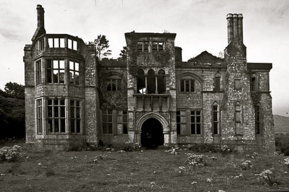
When I first saw the Puxley mansion it was 20 years ago it was a shell of a ruin. It had been the home of the Puxley family since the 1700s. They pretty much owned the copper mining industry here and ended up fabulously wealthy.  As the industry declined so did the Puxley wealth and when his wife died in childbirth Henry Puxley, the last owner, abandoned the castle. Worried that the British Army would take over the abandoned house, the IRA torched it in 1921, destroying it and its contents. The shell was sold at auction in 1927 but remained a forlorn ruin as this photo shows.
b-and-white-puxley

Puxley Manor in the 1990s

This is what it looked like when I saw it in 1996. It was sold to a developer in 1999 and the Celtic Tiger roared. It was to be transformed into a luxury 6-star resort hotel, the only one in Ireland. Massive restoration and conservation work was carried out and all progressed swimmingly with a soft opening in 2007. That was until the money dried up in 2008 with the GFC. By 2010 the project was abandoned and a mesh fence erected. The bats returned but not the visitors.  This is how it appears today. The rotting hull of a large boat sits in the harbour as if to reinforce the tragedy.  Such a grand vision. The restoration did not however extend to the gate house which stands impressively ruinous.

ig3c4651

Puxley Manor.  restored but empty

ig3c4532a

Puxley Manor

ig3c4496

Gatehouse.  Puxley Manor


I said earlier that Dunboy Castle remains were nearby. This was the ancestral home of Donal Cam O’Sullivan, last of the Gaelic chieftains and a thorn in the side of Elizabeth I during the nine years war which started in 1594.  In 1602 she sent a large battalion of troops to destroy O’Sullivan and the 143 men, who tried to defend the castle, could not withstand the British canon. Surrender was not an option after an emissary sent to discuss terms was hung in full view of the defenders. This ultimate fate awaited all those remaining once the British destroyed it and the castle was never lived in again.

The name O’Sullivan however is everywhere on the peninsula.  You can’t avoid it.

ig3c3538

This little enclave of Cork is truly a gem and you could spend a week here or even a lifetime. There are plenty of stone circles, forts, monuments, holy places (such as the Mass Rock) and extraordinary natural wonders to explore and discover.  Oh, and sheep.  And there’s Dursey Island, if the cable car is running.  And if you’re up for it you can walk it all on the Beara Way.

panorama-beara-6

Ring fort

ig3c3756

Mass rock

ig3c4147

The black sheep in the flock

ig3c3540

There once was a church

The beauty though is not just in the grand vistas but in a host of other details for me that capture the personality of a place.  Here are a few photos that speak loudly about the struggle for life for both nature and man.

ig3c4151

Abandoned bucket near a well.

ig3c3769

Perfect bonsai tree growing wild.


ig3c4080

Window treatment

ig3c4404

Ingenuity

ig3c3556

Maintenance can be a problem

ig3c3519a

Fantastically fertile for funghi


ig3c3434

Life hangs on


ig3c4692

True love

ig3c4547a

Faded hope

ig3c4505

Was this to avoid the window tax?

So that’s it.    I’ll be back and very soon.

Categories: My Journey, Real Ireland, Wild Ireland | Tags: , , , , , , , , , , , , , , , , , , , , , | 9 Comments

Blog at WordPress.com.