Posts Tagged With: copper mining

Ireland’s First Copper Mine.  4,500 years of mining history

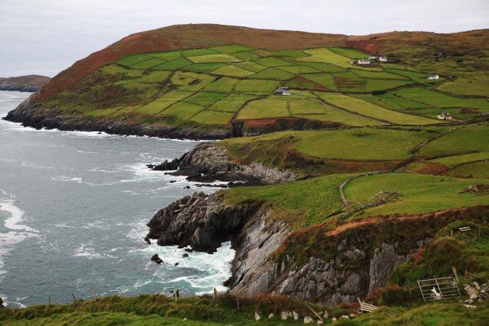
I have stumbled onto historical mining in a number of places in Ireland in my travels.  Particularly at Allihies and Mizen in West Cork and along the so-called Copper Coast in Waterford.  However, I had no idea of the significance of copper mining in Killarney, and only came across it by chance recently when exploring Killarney National Park’s other delights.

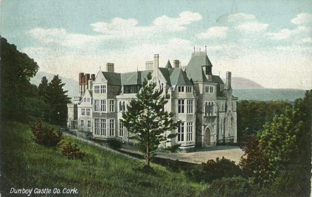
19th Century mining of copper underpinned many fortunes for its British landowners.  In Castletownbere in West Cork,  it was the Puxley’s and Killarney it was the Earls of Kenmare and then the Herberts, who funded their magnificent home at Muckross from their mining wealth.  Ironically the mansion at Muckross was completed in 1843 as the Famine ravaged Ireland.  But the saga of mining in Killarney goes back much further, deep into Neolithic times.

copper-7671

Muckross House built by the Herbert family with money from their mining fortune

copper-7678

Muckross House. Built 1843

When we talk of mining history in Australia, we think back to the first gold rushes in NSW and Victoria, which were in 1851, or Australia’s own copper boom, which started in South Australia in the 1840s. Mining effectively ended Australia’s time as a penal colony and led to an explosion of free immigration.  So it took a bit to wrap my mind around the mining heritage of a country that goes back thousands of years.

Mining has taken place at two locations on the Killarney Lakes, Ross Island and on the Muckross Peninsula.  Mining there reflects human occupancy from the end of the Neolithic Period and the early Bronze Age (2500-1800 BCE) through Christian times (8th Century) to industrialization in the 18th and 19th centuries.

Ross Island is the earliest known site for copper mining in Ireland.  The activity has been dated by the discovery of Beaker pottery by a team from National University of Ireland Galway in 1992.  The so-called Bell Beaker culture is named after the inverted bell-shaped pottery vessels found scattered throughout Western Europe and dated in Ireland from 2500 BCE to 2200 BCE.  This has been confirmed by radiocarbon dating at the site.

b58b979f73b02d15ca6bcc3d894c151c

beaker

Beaker vessel characterstic of the style of the Bell Beaker culture, fragments of which were used to date the Ross Island mining site.  Photo credit: http://curiousireland.ie/the-beaker-people-2500-bc-1700-bc/

The true Bronze Age in Ireland (that is when copper was alloyed with tin or arsenic to manufacture weaponry and tools) started around 2000 BCE.  Prior to this was the ‘Copper Age’ and copper from Ross Island would have been used for daggers or axe heads or other copper objects and was traded widely.  Chemical fingerprinting and lead isotope analysis shows that Ross Island was the only source of copper until 2200 BCE in Ireland. Not only this, but two-thirds of artefacts from Britain before this time show the same signature.  And Ross Island copper is found to be present in artefacts found in Netherlands and Brittany.  After this time other mines from southern Ireland became more important.

So, Ross Island saw the transition from the Neolithic to the Bronze Age.  Frankly, to me as a mining geologist, to be able to stand on the place where the mining took place that underpinned this highly significant transition in human development in Ireland was, for me, a special experience.

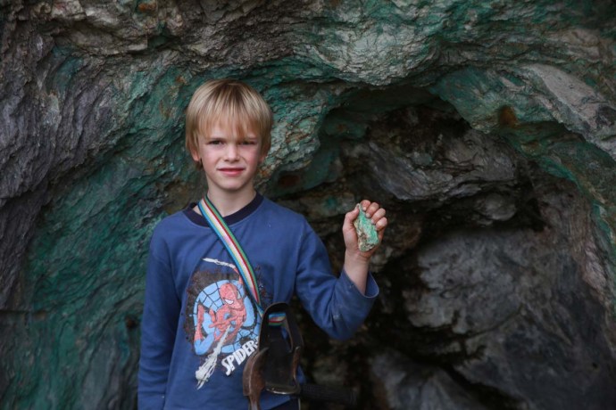
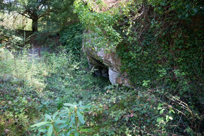
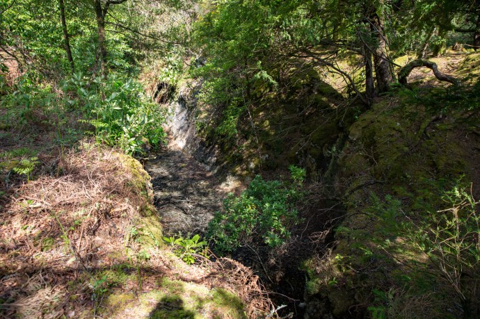
The early miners exploited a rich band of oxidized copper ore within the limestone through shallow cave-like excavations, tunnels and chambers, most of which were damaged by subsequent mining.  Some of the surface ‘caves’ are visible today behind a rusting iron fence though the view is unfortunately heavily obscured by vegetation, which has been allowed to grow unchecked.

copper-7953

Bronze Age mining excavation Ross Island

copper-7956

Bronze Age mining Ross Island

copper-7954

Probable Bronze Age mining excavation with later 18th Century stone walls.

These openings were made in the days well before explosives, by lighting fires against the rock face to open fractures and then pounding the walls with stone hammers.  The broken rock was then hand sorted and the separated ore was converted to metal by smelting in pit furnaces.

The last of the first phase of mining from this site is dated at 1700 BCE.  Mining lay dormant for centuries then, but in the early Christian period was a Golden Age of metalworking in Ireland, when such treasures as the Tara Brooch were produced.  Killarney was one of the centers of metallurgical and artisanal skills.  Excavations at Ross Island have found small pit furnaces that date from 700 AD suggesting that ores from here were used to produce metals for the production of  such objects.

Another thousand years passed before the final chapter in the exploitation of the wealth of Killarney copper played out.

This last phase of mining commenced in the early 18th century.  The first attempts at extracting lead in 1707 and then again to work the mine in 1726 failed.  In 1754 Thomas Herbert commenced mining under an arrangement with the then landowner, the Earl of Kenmare.  Mining was difficult due to flooding from proximity to the lake edge and for the next fifty years was sporadic.

I must digress for a moment.  In 1793 Thomas Herbert invited a mining consultant Rudolf Raspe to advise on the mines.  Why do I mention this?  Raspe was German and author of The Fabulous Adventures of the Baron von Munchausen (published in 1785). You might have seen the movie or heard of ‘Munchausen Syndrome’ but I grew up with these fantastical stories read to me by my father. Who would have dreamt of a connection between these far-fetched tales and copper mining in the west of Ireland. Anyway the poor fellow didn’t have such a Fabulous ending dying of scarlet fever a few months later and being buried in an unmarked grave near Muckross.

Meanwhile mining on Muckross Peninsula started in 1749 on the Western Mine and by 1754 the company had raised some £30,000 worth of copper ore, which was shipped to Bristol for smelting.  This closed in 1757 and operations commenced on the Eastern Mine opening for short periods in 1785 and again in 1801.  Operations resumed on the Western Mine in 1795 but these failed due apparently to mismanagement.  Little more was heard of this mine and it was considerably less successful than its neighbour.

copper-7465

Mining spoil at Muckross Mine seen from the lake

copper-7189

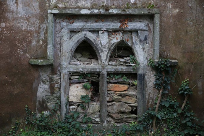
Muckross Peninsula.  18th Century smelter building

copper-7187

Inside smelter building showing unusual curve flue.  There were at least three smelting furnaces in the structure.

copper-7198

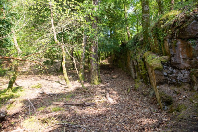
Muckross Peninsula. Old mine building

But things might have been very different. A dark crystalline mineral was encountered which oxidised to a very bright pink.  It had no copper and so was discarded.  One miner recognised it as the cobalt ore, cobaltite (CoAsS), with its oxidized form, pink erythrite (Co3(AsO4)28H2O).  This man quietly removed twenty tons of this ‘rubbish’ undiscovered.  When the proprietor later realised its value, it was too late.  It had been removed by his helpful employee, or mined as waste and thrown away to expose the copper ore.  Reminds me of the non-recognition of the gold rich Telluride ores in Kalgoorlie in 1893, which for years were used to surface roads, until a way was discovered to extract the gold.  Needless to say, the roads were ripped up.

58023det

Erythrite from Muckross.  Photo credit: Online Mineral Museum

Back to the Ross Mine, which at the beginning of the 19th century had another renaissance. The Ross Island Company obtained a 31 year mining lease from Lord Kenmare in 1804, Work commenced on the Blue Hole on a rich lode of lead and copper. Mining continued until 1810 by which time it had become unprofitable.

copper-7911

Blue Hole Mine open pit

copper-7916

Northern pit Blue Hole Mine. Mining completed 1810

The operation was restarted by the Hibernian Mining Company (1825-9).  Both struggled with the perpetual problem of flooding.  One solution suggested was to drain Lough Leane; this did not go down too well as you can imagine, particularly with the local boatmen.  In the end a large coffer dam was built on the shore and water pumped into it from the mine. Part of the dam is still there.  Bigger and bigger pumps were required and ultimately by 1828 they were unable to deal with the water and the mine closed. Most of the Western Mine area is now flooded as the dam walls have been breached

copper-7925

Eastern coffer dam.

copper-

Part of Western Mines area flooded by breached dam wall on left.

copper-7866

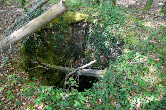
Ross Island.  A walled off limestone cave with steel door.  My hunch it was used as a magazine.

copper-7928

Old shaft near Blue Hole mine

copper-7932

Site of Old Engine House Ross Island Mine

Wandering over the site today does not give a true sense of the scale of mining in the early 19th century.  This map by Thomas Weaver from 1829 shows the fifty or so shafts, underground tunnels and surface buildings from this phase of operations.

new_pa2

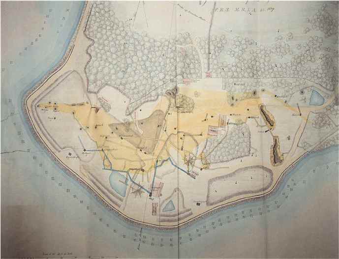
Thomas Weaver map of Ross Island mine workings 1829.  Photo credit NUIG.

But mining grew out of favour and conflicted with the rise of tourism to the area.   No more mine leases were granted after 1829 by the Herberts, who by this time had transitioned from mining entrepreneurs to landowners. The area was carefully landscaped, with the infilling of shafts, flooding of the Blue Hole, the demolition of buildings and the planting of trees. Subsequent forest growth has softened the historic footprint of the mining

Mineral exploration is now prohibited in the National Park so the remarkable 4,500 year history of mining here has come to an end.  Public awareness however of this important site is increasing with the creation of a Mining Trail and explanatory signage at the site.  To me, places like this are as important as Glendalough and Ceidi Fields and their preservation is so important.

I am ashamed to say that after five years in Ireland I only discovered this place by accident.  But find it I did, and I will be back there as soon as I can be.


Much of the material for this blog came from the informative website of the National University of Ireland Galway who completed the archaeological study of the historical mining sites in 1992.   http://www.nuigalway.ie/ross_island/.  My thanks and acknowledgement to them.

Categories: My Journey, Real Ireland | Tags: , , , , , , , , , , , , , , , , | Leave a comment

The Beach at Allihies, Co. Cork. A Beautiful Legacy of Ignorance and Indifference.

Allihies is a very photogenic village near the tip of the Beara Peninsula. I have blogged on it before (click here).   There I gave an overview of the whole Beara Peninsula as well as highlighting the extensive history of copper mining in the area,  but I didn’t mention the pretty beach near Allihies, which I didn’t visit last time.

IG3C4137

The beach at Allihies

Back in the Beara recently, I had a bit more time and found myself on the strand during a break in the bleak weather.  This beautiful place has a very interesting back story and an unexpected connection to the mining operations located high up in the hills above the village.

The beach is a surprise.  It seems like it shouldn’t be there. The whole coastline here is rugged and rocky and apparently too wild for sand to accumulate.  And yet there it is, an extensive thick accumulation of golden sand in a protected inlet.

IG3C4147

The inlet at Ballydonegan with the Allihies Beach, the village in the background and the Caha Mountains

IG3C4028

A glorious setting and safe.

IG3C4138

Sand, water, rocks and sky

A close look however shows all is not what it seems.

The sand is very coarse.  It is also very uniform in size and it only comprises fragments of quartz and shale.  There are no organic bits or shell fragments as you would expect.  In fact is unlike any beach sand I have seen.  There are no dunes; just a thick deposit of banded unconsolidated coarse sand.  And due to the lack of fines, it is not compacted as might be expected. It is very hard to walk on and especially hard to climb its slopes.

IG3C3970

Coarse sand.  Lots of quartz and rock fragments

IG3C4098

Thick banded sand.

So where did it come from?

This is where the mining comes in.  Copper mining took place at Allihies for over 70 years starting in 1813.  In its day it was the largest copper production centre in Europe.   Allihies was remote and there were no environmental or safety controls and the Mine Captains pretty much did what they liked.  So rather than build an expensive dam to contain the tailings they were pumped into the local rivers that eventually found their way to the coast at Ballydonegan.  Standard practice then.  Environmental vandalism today.

IG3C4113

Tailings sand deposited among the rocks near the mouth of the river

IG3C4080

The mouth of the river.  Some unusual giant ripples.

So what are tailings?  In hard rock mining the rock containing copper minerals is brought to the surface for processing.  The total percentage of copper minerals may only be about 2-5% so over 95% of the rock mined must be disposed of.  It is crushed and then the copper minerals are separated with the remainder of the rock disposed of.   It was lucky that the processing this time didn’t involve toxic chemicals so the tailings was reasonably clean.   It accumulated at the mouth of the river and eventually the Atlantic Ocean converted it into a beach.  The vast majority of visitors are probably totally unaware that it is man-made.

It is a pretty place.  A great safe swimming beach and stunning views.  It is ironic though that in the 21st century it is one of the attractions of the area whereas two centuries ago it would have been a major blight on the landscape and that a place of such beauty exists because of man’s indifference and ignorance.

IG3C3991

Tranquil and empty.  Mid June.

IG3C4038

Not quite empty.  Holiday makers from the popular adjacent caravan park


Categories: My Journey, Real Ireland, Wild Ireland | Tags: , , , , , , , , , , , , , , , , , , , , , | Leave a comment

The Beara Peninsula, Co Cork. My New Favourite Place in Ireland.

I hope my blogs on Ireland aren’t getting too boring. Each time I discover or rediscover a new place I can’t stop scraping up the superlatives.  I’ve blogged recently on the magic of Glencolmcille and south west Donegal, on the spirit of Achill Island, on the beauty of Doughmore in West Clare and West Connemara and many places in between. Recently I visited the Beara Peninsula again for the first time in twenty years. And I’m sorry but I have to regale you with more resplendent words yet again.

The Beara Peninula is one of those wonderful headlands that define West Kerry and West Cork, jutting prominently into the Atlantic and adding a whole lot of extra kilometres to the Wild Atlantic Way.  Many have well known and evocative connotations. The Iveragh Peninsula, better known as the Dingle Peninsula,  and the famous Ring of Kerry are the prime destinations for visitors and do not fail to disappoint. Less well known are the Beara Peninsula, Sheep’s Head and the spectacular Mizen Head.

The attractions of the Beara Peninsula are however becoming better known and I am told by the locals that this summer it was crowded with visitors. I chose to visit in late October. The weather was good (in Irish-speak that translates to ‘no rain’) and it has to be the perfect time. At the western end, the roads are almost deserted and you feel you have this magnificent landscape to yourself.

An obvious draw of this place is that it is more compact than the Ring of Kerry but there is so much variety, so much of interest and so much to fill the shortening autumn days that it was hard to leave.

So what does this little treasure offer?  For a start magnificent vistas are around every corner. You can approach from the Northern Road or the Southern Road but my strong recommendation is you find time to do both.

panorama-beara-3

ig3c3378aig3c3484ig3c3436ig3c3681ig3c3706a

And sometimes you see something that you know could not be replicated anywhere else in the world.  The patchwork quilt and stone walls that say Ireland, Ireland, Ireland.

ig3c4109aig3c4224aig3c4066

There are a number of mountainous rocky passes. I explored the Caha Pass this time, which links Kenmare with Glengariff. Here there is stunning scenery and four remarkable tunnels (known as Turner’s Rock Tunnels) built in the 1840s when they decided to go through the rock rather than over it. Quite an engineering feat for its day and very unique for road construction as most tunnels in Ireland were built for railways. Indeed the railway construction boom did not start until the 1840s so these tunnels predate any rail tunnel in Ireland.   From this impressive road there are craggy mountains, magnificent pasture and grasslands, and sweeping panoramas. Next time I will do the Healy Pass.

ig3c4805aig3c4741ig3c4801ig3c4826aig3c4731

Elsewhere you will see wild, coastal panoramas, verdant forests, jagged islands or houses perched on grassy knolls with staggering views or nestled into rugged rocky cliffs.

panorama-beara-4ig3c3780ig3c3820

ig3c3635a

ig3c3716ig3c3493

ig3c3916aig3c3841a

The drive to the end of the Peninsula and Dursey Island is not to be missed. But be prepared for perhaps a little disappointment. Ireland’s only cable car which links the island to the mainland and at this time of the year only runs between 9.30am and 11am was ‘fully booked’ and not operating for transport of people. It was being used for the day by the local farmers to transport hay across the narrow channel. Where else would tourists be turned away, some mind you who had travelled especially, in favour of bales of hay? Only in Ireland. But somehow it didn’t matter, there was so much else to do and it will be there (possibly) next time. You’ve got to admire the ingenuity of the farmers here. I saw an old ‘retired’ cable car in a yard being used as a chook house. Love it.  And love the little insect houses thoughtfully provided by one farmer.

ig3c4000ig3c4016ig3c4034

Then there is the colourful palette of the charming village of Allihies, which single-handed may be responsible for keeping alive the paint pigment industry in Ireland. Purples, pinks, indigo and every other colour merged harmoniously into the greys, greens and reds of its rocky backdrop.

ig3c4383a

ig3c4264a

And towering over the town is the architectural masterpiece of the Engine House of the Mountain Copper Mine built around 1810. Maybe you think masterpiece too strong a word  but it is at least the equal from a heritage perspective of the megalithic ruins or the monastic abbeys that populate the tourist guide books.   This is the finest example of an historical mine building I have seen in this remarkable condition. It speaks of the confidence and wealth that the mine brought to this remote outpost as it became one of the jewels of European copper mining during its heyday from 1810 to its closure in the 1920s. There are plenty of reminders of the mining period; old shafts and adits, mine workings, two other engine house ruins, stone walls and in places the tell-tale green and blue staining of copper carbonates.

ig3c4369a

Mountain Mine engine house

ig3c4362ig3c4290ig3c4275

ig3c4321

Chasing the copper


There is a museum which gives a very good account of the mining story but unfortunately it is a bit expensive which turns some away. All aspects of the story are covered including the geology, mining technology and social impact.   As a geologist it was of course fascinating. And even more so for me having met the next generation of miner there, young J and his mum Frances, locals who had come to see if they could find any copper. As it happened I had seen some workings with strong copper on the way up the hill, so I offered to show them and took them there. J’s wide eyed fascination and enthusiasm was enough reward.  Maybe I have helped kick start another geologist’s career.

ig3c4394ig3c4389

Still on copper, I stopped at Puxley Manor near Castletownbere. Actually the site of the mansion is right near the ruins of Dunboy Castle but more on that later. It would seem that the location is well cursed having witnessed a number of tragedies over the past 4oo+ years.

24_ctb_ah-635x402

Puxley Manor around 1910

When I first saw the Puxley mansion it was 20 years ago it was a shell of a ruin. It had been the home of the Puxley family since the 1700s. They pretty much owned the copper mining industry here and ended up fabulously wealthy.  As the industry declined so did the Puxley wealth and when his wife died in childbirth Henry Puxley, the last owner, abandoned the castle. Worried that the British Army would take over the abandoned house, the IRA torched it in 1921, destroying it and its contents. The shell was sold at auction in 1927 but remained a forlorn ruin as this photo shows.

b-and-white-puxley

Puxley Manor in the 1990s

This is what it looked like when I saw it in 1996. It was sold to a developer in 1999 and the Celtic Tiger roared. It was to be transformed into a luxury 6-star resort hotel, the only one in Ireland. Massive restoration and conservation work was carried out and all progressed swimmingly with a soft opening in 2007. That was until the money dried up in 2008 with the GFC. By 2010 the project was abandoned and a mesh fence erected. The bats returned but not the visitors.  This is how it appears today. The rotting hull of a large boat sits in the harbour as if to reinforce the tragedy.  Such a grand vision. The restoration did not however extend to the gate house which stands impressively ruinous.

ig3c4651

Puxley Manor.  restored but empty

ig3c4532a

Puxley Manor

ig3c4496

Gatehouse.  Puxley Manor


I said earlier that Dunboy Castle remains were nearby. This was the ancestral home of Donal Cam O’Sullivan, last of the Gaelic chieftains and a thorn in the side of Elizabeth I during the nine years war which started in 1594.  In 1602 she sent a large battalion of troops to destroy O’Sullivan and the 143 men, who tried to defend the castle, could not withstand the British canon. Surrender was not an option after an emissary sent to discuss terms was hung in full view of the defenders. This ultimate fate awaited all those remaining once the British destroyed it and the castle was never lived in again.

The name O’Sullivan however is everywhere on the peninsula.  You can’t avoid it.

ig3c3538

This little enclave of Cork is truly a gem and you could spend a week here or even a lifetime. There are plenty of stone circles, forts, monuments, holy places (such as the Mass Rock) and extraordinary natural wonders to explore and discover.  Oh, and sheep.  And there’s Dursey Island, if the cable car is running.  And if you’re up for it you can walk it all on the Beara Way.

panorama-beara-6

Ring fort

ig3c3756

Mass rock

ig3c4147

The black sheep in the flock

ig3c3540

There once was a church

The beauty though is not just in the grand vistas but in a host of other details for me that capture the personality of a place.  Here are a few photos that speak loudly about the struggle for life for both nature and man.

ig3c4151

Abandoned bucket near a well.

ig3c3769

Perfect bonsai tree growing wild.


ig3c4080

Window treatment

ig3c4404

Ingenuity

ig3c3556

Maintenance can be a problem

ig3c3519a

Fantastically fertile for funghi


ig3c3434

Life hangs on


ig3c4692

True love

ig3c4547a

Faded hope

ig3c4505

Was this to avoid the window tax?

So that’s it.    I’ll be back and very soon.

Categories: My Journey, Real Ireland, Wild Ireland | Tags: , , , , , , , , , , , , , , , , , , , , , | 9 Comments

Blog at WordPress.com.