Posts Tagged With: Dursey

Dursey. An island at the end of Ireland.

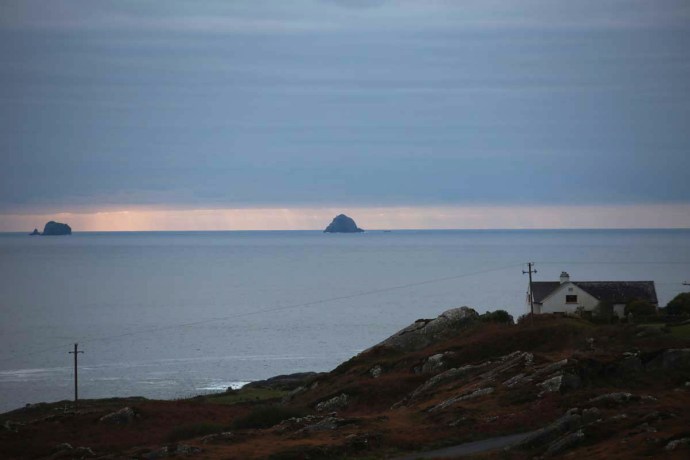
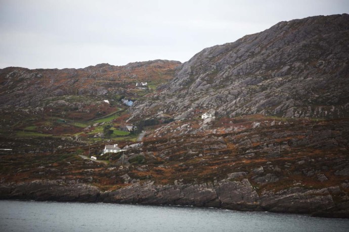
Dursey Island lies at the end of the Beara Peninsula in West Cork. It has been inhabited since antiquity and though it lies only 200 m from the mainland it has always been one of the most remote and inhospitable places to live in in the whole country.

IG3C3006

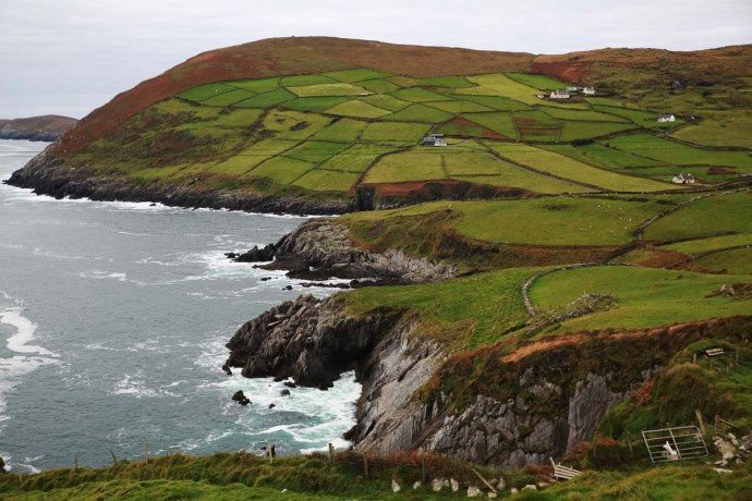
Dursey Island looking towards the mainland.

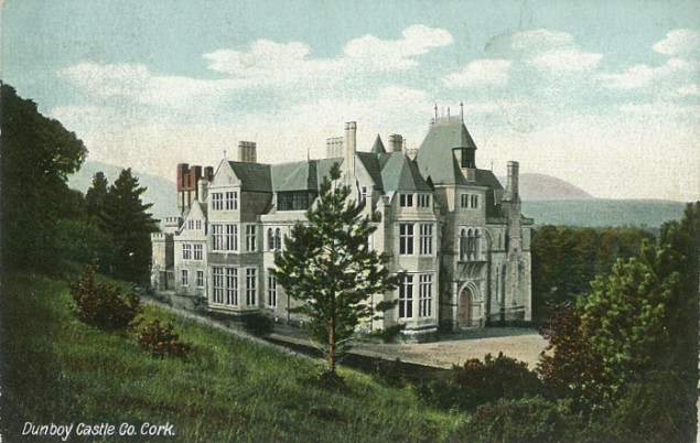
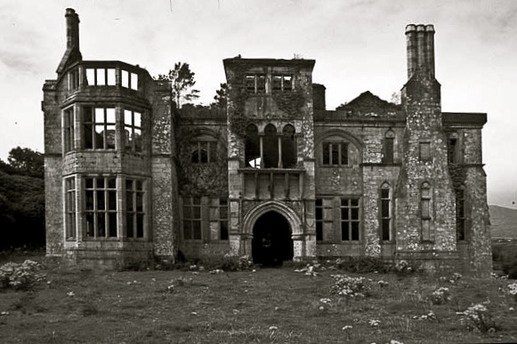
It had a tortured early existence and was the site of one of the most horrific events in Irish history.  Following the Battle of Kinsale and the defeat of Donal Cam O’Sullivan at Dunboy in early 1602, the English moved to clean up the last of the rebels.  Many of the O’Sullivan Clan’s non-combatants had been sent to  Dursey to keep them out of harm’s way.  An English force attacked the small garrison guarding the island. They butchered the entire population of the island, women, children and the garrison. Three hundred people executed on the cliffs and their bodies (some were still alive) cast into the sea.  O’Sullivan survivors from the whole of the Beara Peninsula, about 1,000 of them, then marched 550 km north to seek shelter from the O’Rourkes of Leitrim, but that’s another story.

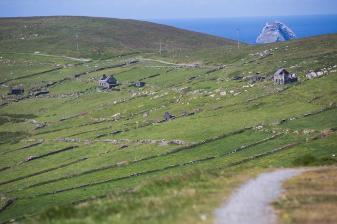
As with the rest of the west coast of Ireland, Dursey suffered during the famine with a 30% reduction in its population in the 1840s.  Its subsequent and continuing depopulation reflects that of many other Irish islands but its survival displays the resilience and strength of its people. In 1860 the three villages of Ballynacallagh, Kilmichael and Tilickafinna,  a population of around 240 eked out a lonely life on the treeless but well pastured island.  By 1969 this number was down to 53. A feature of the island now is the large number of abandoned houses from these times.  This eloquently tell the story of a disappearing population, but they also give the island its remarkable character.

IG3C2842

Abandoned village

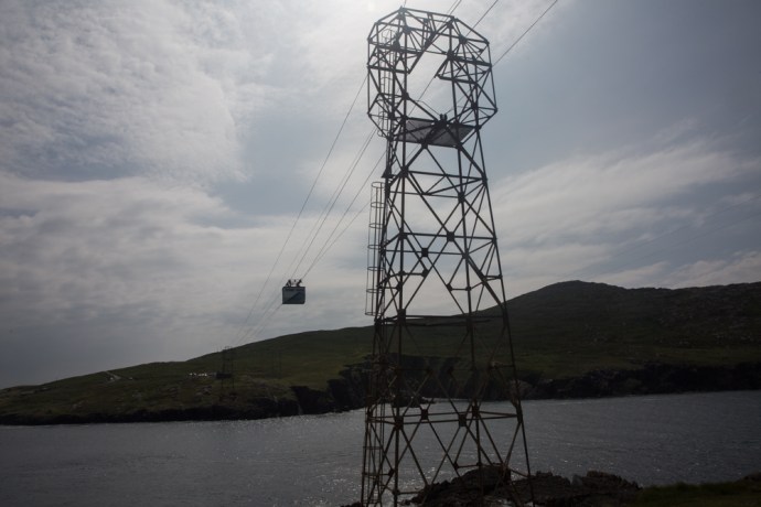
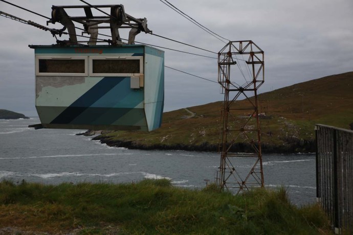
Up until 1970 the only way to get on and off the island was by boat across the channel.  A channel that could become so treacherous with storms and a tidal surge  that for a month and a half each year the island was completely cut off.  Considering that there was no electricity, TV, doctor, priest, food supplies and no hall or pub, life must have been very bleak indeed.   After much agitation from islanders the Government agreed to build a cable car to provide a lifeline and, while that did save it from the same fate as the Blaskets, which were abandoned in 1953, it did not stop the population drain until, by 2011, there were only three permanent residents.

IG3C2411

Treacherous tides and surges made this channel very dangerous to cross.  Not these days.

IG3C2448

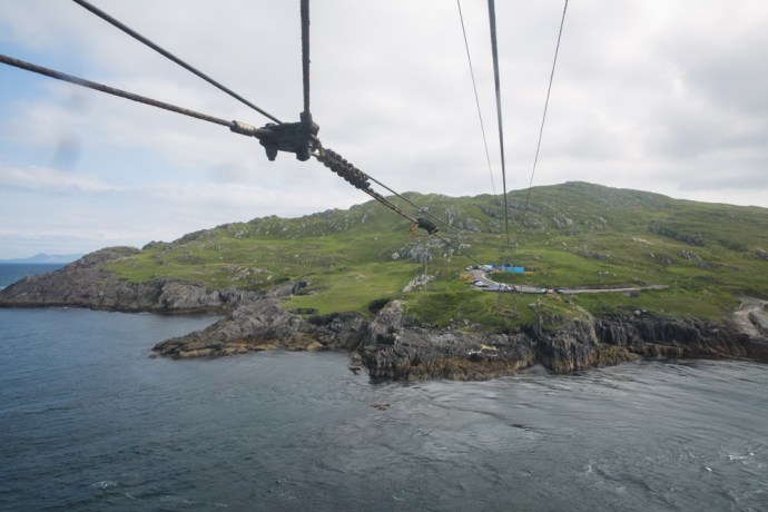
Approaching the island

IG3C2435

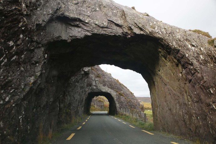
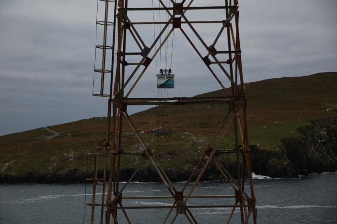
Anticipation. A picture window.

But the cable car opened the island to the tourist.  6.5 km in length, there is much of interest.

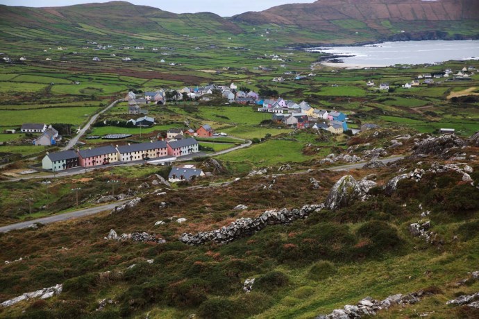
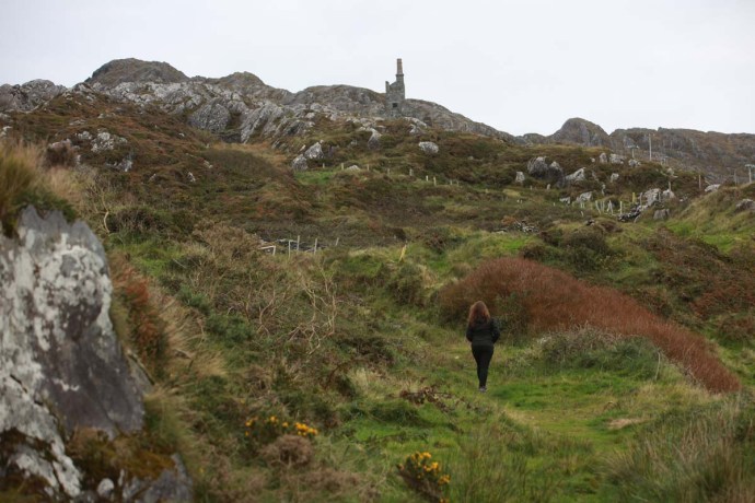
To walk the island takes at least 4 hours but I spent over 6 hours ambling and rambling, getting lost and finding myself again.  Just absorbing the ambiance and grateful for the glorious sunshine and the warm breeze that accompanied me. It is glorious to walk either along the sometimes paved road (which despite the alarming speed sign is almost devoid of vehicles;  I saw only one) or across the hills but best to stay on the marked paths unlike me.

IG3C2470

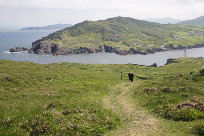
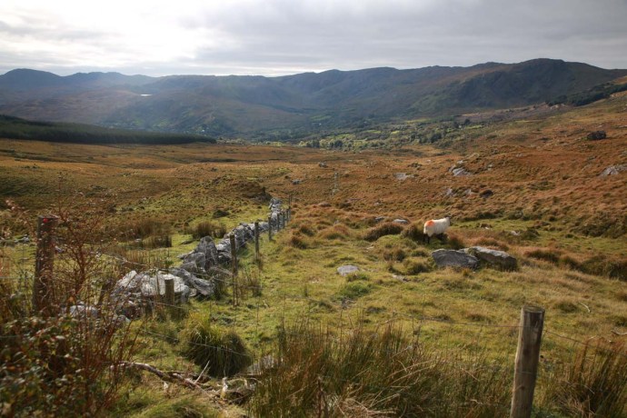
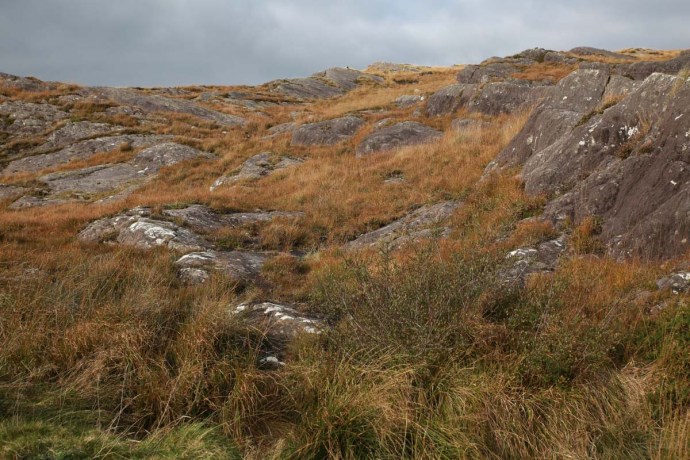
There is a marked walking trail across the hills.  Looking across to the mainland.

IG3C2486

If you leave the path walking through thick vegetation and across stone walls can be a challenge.

IG3C2790

I can never understand Irish speed limits.  100 kph!?

IG3C2880

Looking from the western tip of the island back towards the mainland.  A signal tower stands on the highest point.

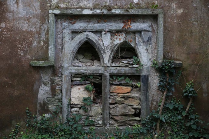
On your walk you will come across the remains  of St Mary’s Abbey, a Napoleonic signal tower, historic ruins, spectacular views, rocky cliffs, birds galore, native orchids and your best chance  in Ireland to see dolphins and whales.
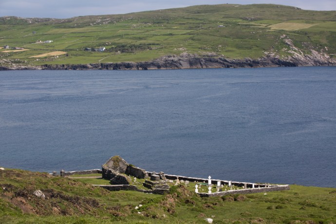
IG3C3170

St Mary’s Abbey

IG3C2623

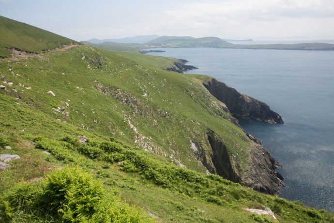
Cliffs on the southern side of the island

IG3C2647

Dolphins

IG3C2727

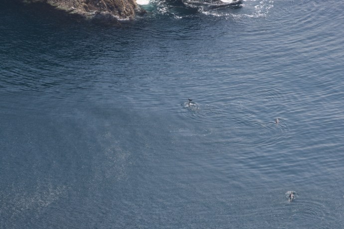
I tracked this pod of dolphins for over half an hour down the coast

IG3C2928

Native orchids are common

At the western end of the island are three small islands.  Well, rocks really.  They are known as Calf Rock, Cow Rock and yes, you guessed it, Bull Rock.

IG3C2799

Looking west across Dursey to the imposing Bull Rock, two miles off shore

IG3C2889

Cow Rock and Bull Rock

A lighthouse was established on  Calf Rock in 1866.

Less than three years later a storm damaged the lighthouse.  This led to another tragic event in the saga of Dursey.  The Keeper, on Dursey, thought he saw distress flags and six boatmen were dispatched.  Those on the island were safe however, on the the return trip, the boat capsized and all six were lost

On 27 November 1881 in another  violent storm the the tower and lantern just snapped off above the steel base and fell into the sea. No one was hurt but it took two weeks to extract the four men stranded on the island. You can still see the base of the tower to this day.

IG3C2897

Calf Rock with the remains of the steel base of the light tower. Wrecked in 1881

To replace this lighthouse one was built on nearby Bull Rock, work commencing in  1882.  The light didn’t open until 1888.  It is worth pondering the challenge of constructing this on an island of precipitous cliffs measuring 230 m by 160 m and rising to 90 m above sea level.

The station consisted of an octagonal lighthouse tower, dwellings for the Keepers, and an oil-gas works.   This was a massive undertaking and the optic was the biggest in Ireland.

IG3C2915

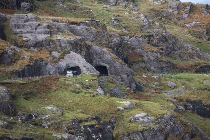
Bull Rock with its lighthouse.  You can also see a gull colony and the entrance to a natural tunnel that goes right through the island.

The light still stands proudly today though it was automated in 1991. The island is swarming with gulls.  Also noteworthy is a natural tunnel that goes right through the island.  You can see the eastern entrance in the picture above.

That’s Dursey.   Take everything you think you’ll need because there are no supplies on the island and not even a toilet. And it won’t always be mild and sunny as it was for me; go prepared for bleak and wild.

But don’t miss it.

IG3C3225


Categories: My Journey, Real Ireland, Wild Ireland | Tags: , , , , , , , , , , , , , , , , , , , , , , , | Leave a comment

The Beara Peninsula, Co Cork. My New Favourite Place in Ireland.

I hope my blogs on Ireland aren’t getting too boring. Each time I discover or rediscover a new place I can’t stop scraping up the superlatives.  I’ve blogged recently on the magic of Glencolmcille and south west Donegal, on the spirit of Achill Island, on the beauty of Doughmore in West Clare and West Connemara and many places in between. Recently I visited the Beara Peninsula again for the first time in twenty years. And I’m sorry but I have to regale you with more resplendent words yet again.

The Beara Peninula is one of those wonderful headlands that define West Kerry and West Cork, jutting prominently into the Atlantic and adding a whole lot of extra kilometres to the Wild Atlantic Way.  Many have well known and evocative connotations. The Iveragh Peninsula, better known as the Dingle Peninsula,  and the famous Ring of Kerry are the prime destinations for visitors and do not fail to disappoint. Less well known are the Beara Peninsula, Sheep’s Head and the spectacular Mizen Head.

The attractions of the Beara Peninsula are however becoming better known and I am told by the locals that this summer it was crowded with visitors. I chose to visit in late October. The weather was good (in Irish-speak that translates to ‘no rain’) and it has to be the perfect time. At the western end, the roads are almost deserted and you feel you have this magnificent landscape to yourself.

An obvious draw of this place is that it is more compact than the Ring of Kerry but there is so much variety, so much of interest and so much to fill the shortening autumn days that it was hard to leave.

So what does this little treasure offer?  For a start magnificent vistas are around every corner. You can approach from the Northern Road or the Southern Road but my strong recommendation is you find time to do both.

panorama-beara-3

ig3c3378aig3c3484ig3c3436ig3c3681ig3c3706a

And sometimes you see something that you know could not be replicated anywhere else in the world.  The patchwork quilt and stone walls that say Ireland, Ireland, Ireland.

ig3c4109aig3c4224aig3c4066

There are a number of mountainous rocky passes. I explored the Caha Pass this time, which links Kenmare with Glengariff. Here there is stunning scenery and four remarkable tunnels (known as Turner’s Rock Tunnels) built in the 1840s when they decided to go through the rock rather than over it. Quite an engineering feat for its day and very unique for road construction as most tunnels in Ireland were built for railways. Indeed the railway construction boom did not start until the 1840s so these tunnels predate any rail tunnel in Ireland.   From this impressive road there are craggy mountains, magnificent pasture and grasslands, and sweeping panoramas. Next time I will do the Healy Pass.

ig3c4805aig3c4741ig3c4801ig3c4826aig3c4731

Elsewhere you will see wild, coastal panoramas, verdant forests, jagged islands or houses perched on grassy knolls with staggering views or nestled into rugged rocky cliffs.

panorama-beara-4ig3c3780ig3c3820

ig3c3635a

ig3c3716ig3c3493

ig3c3916aig3c3841a

The drive to the end of the Peninsula and Dursey Island is not to be missed. But be prepared for perhaps a little disappointment. Ireland’s only cable car which links the island to the mainland and at this time of the year only runs between 9.30am and 11am was ‘fully booked’ and not operating for transport of people. It was being used for the day by the local farmers to transport hay across the narrow channel. Where else would tourists be turned away, some mind you who had travelled especially, in favour of bales of hay? Only in Ireland. But somehow it didn’t matter, there was so much else to do and it will be there (possibly) next time. You’ve got to admire the ingenuity of the farmers here. I saw an old ‘retired’ cable car in a yard being used as a chook house. Love it.  And love the little insect houses thoughtfully provided by one farmer.

ig3c4000ig3c4016ig3c4034

Then there is the colourful palette of the charming village of Allihies, which single-handed may be responsible for keeping alive the paint pigment industry in Ireland. Purples, pinks, indigo and every other colour merged harmoniously into the greys, greens and reds of its rocky backdrop.

ig3c4383a

ig3c4264a

And towering over the town is the architectural masterpiece of the Engine House of the Mountain Copper Mine built around 1810. Maybe you think masterpiece too strong a word  but it is at least the equal from a heritage perspective of the megalithic ruins or the monastic abbeys that populate the tourist guide books.   This is the finest example of an historical mine building I have seen in this remarkable condition. It speaks of the confidence and wealth that the mine brought to this remote outpost as it became one of the jewels of European copper mining during its heyday from 1810 to its closure in the 1920s. There are plenty of reminders of the mining period; old shafts and adits, mine workings, two other engine house ruins, stone walls and in places the tell-tale green and blue staining of copper carbonates.

ig3c4369a

Mountain Mine engine house

ig3c4362ig3c4290ig3c4275

ig3c4321

Chasing the copper


There is a museum which gives a very good account of the mining story but unfortunately it is a bit expensive which turns some away. All aspects of the story are covered including the geology, mining technology and social impact.   As a geologist it was of course fascinating. And even more so for me having met the next generation of miner there, young J and his mum Frances, locals who had come to see if they could find any copper. As it happened I had seen some workings with strong copper on the way up the hill, so I offered to show them and took them there. J’s wide eyed fascination and enthusiasm was enough reward.  Maybe I have helped kick start another geologist’s career.

ig3c4394ig3c4389

Still on copper, I stopped at Puxley Manor near Castletownbere. Actually the site of the mansion is right near the ruins of Dunboy Castle but more on that later. It would seem that the location is well cursed having witnessed a number of tragedies over the past 4oo+ years.

24_ctb_ah-635x402

Puxley Manor around 1910

When I first saw the Puxley mansion it was 20 years ago it was a shell of a ruin. It had been the home of the Puxley family since the 1700s. They pretty much owned the copper mining industry here and ended up fabulously wealthy.  As the industry declined so did the Puxley wealth and when his wife died in childbirth Henry Puxley, the last owner, abandoned the castle. Worried that the British Army would take over the abandoned house, the IRA torched it in 1921, destroying it and its contents. The shell was sold at auction in 1927 but remained a forlorn ruin as this photo shows.

b-and-white-puxley

Puxley Manor in the 1990s

This is what it looked like when I saw it in 1996. It was sold to a developer in 1999 and the Celtic Tiger roared. It was to be transformed into a luxury 6-star resort hotel, the only one in Ireland. Massive restoration and conservation work was carried out and all progressed swimmingly with a soft opening in 2007. That was until the money dried up in 2008 with the GFC. By 2010 the project was abandoned and a mesh fence erected. The bats returned but not the visitors.  This is how it appears today. The rotting hull of a large boat sits in the harbour as if to reinforce the tragedy.  Such a grand vision. The restoration did not however extend to the gate house which stands impressively ruinous.

ig3c4651

Puxley Manor.  restored but empty

ig3c4532a

Puxley Manor

ig3c4496

Gatehouse.  Puxley Manor


I said earlier that Dunboy Castle remains were nearby. This was the ancestral home of Donal Cam O’Sullivan, last of the Gaelic chieftains and a thorn in the side of Elizabeth I during the nine years war which started in 1594.  In 1602 she sent a large battalion of troops to destroy O’Sullivan and the 143 men, who tried to defend the castle, could not withstand the British canon. Surrender was not an option after an emissary sent to discuss terms was hung in full view of the defenders. This ultimate fate awaited all those remaining once the British destroyed it and the castle was never lived in again.

The name O’Sullivan however is everywhere on the peninsula.  You can’t avoid it.

ig3c3538

This little enclave of Cork is truly a gem and you could spend a week here or even a lifetime. There are plenty of stone circles, forts, monuments, holy places (such as the Mass Rock) and extraordinary natural wonders to explore and discover.  Oh, and sheep.  And there’s Dursey Island, if the cable car is running.  And if you’re up for it you can walk it all on the Beara Way.

panorama-beara-6

Ring fort

ig3c3756

Mass rock

ig3c4147

The black sheep in the flock

ig3c3540

There once was a church

The beauty though is not just in the grand vistas but in a host of other details for me that capture the personality of a place.  Here are a few photos that speak loudly about the struggle for life for both nature and man.

ig3c4151

Abandoned bucket near a well.

ig3c3769

Perfect bonsai tree growing wild.


ig3c4080

Window treatment

ig3c4404

Ingenuity

ig3c3556

Maintenance can be a problem

ig3c3519a

Fantastically fertile for funghi


ig3c3434

Life hangs on


ig3c4692

True love

ig3c4547a

Faded hope

ig3c4505

Was this to avoid the window tax?

So that’s it.    I’ll be back and very soon.

Categories: My Journey, Real Ireland, Wild Ireland | Tags: , , , , , , , , , , , , , , , , , , , , , | 9 Comments

Blog at WordPress.com.