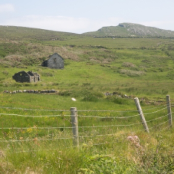
This is my longest blog to date. It is also one I have had the most pleasure writing. It is about a special place. Never visited by tourists and only by a handful of locals. A place where little vignettes of a vanished Ireland can be glimpsed, where nature has done its wonderful work and where you can find peace in solitude. I hope you find the time to read it and that I can give you a little of this feeling in these words and pictures.
I live on the edge. Of Ireland, that is.
Every morning I pull the curtains and look out my window across Caherush bay. The first thing I see is Mutton Island. It’s the image that begins every day. Sometimes the cloud or mist or the spray from wild waves hides it and sometimes it is like a green jewel floating on a blue calm. I’ve seen it covered in snow and I’ve seen it bathed in the glow of a West Clare sunset. But in four years I’d never been there.

Sunset over Mutton Island viewed from Seafield Beach at Quilty.

Mutton Island during the ‘Beast from the East’ in March 2018. Covered in thick snow.
The island of 185 acres is shrouded in myth and mystery. It’s inaccessibility gives these stories weight.
There is no obvious way to get there for those of us who don’t own a boat or a kayak, but I decided one July Tuesday in the midst of an extraordinary spell of hot, fine weather to try and get there.
My inquiries led me to Anthony Murrihy, a Quilty fisherman, and so 10am Wednesday saw me waiting at the Seafield Pier to be ferried across. Well, after two weeks of blue skies, this morning arrived with low cloud covering Quilty and the island. Mmmm. That’s Ireland. Still there was no rain and it was just a bit cooler than it had been which in the end I was grateful for.
As the little red boat pulled away from the Quilty shore, it somehow seemed appropriate that the island should be shrouded in mist. Why would it give up its secrets so easily?

Anthony Murrihy, Quilty fisherman. Leaving Seafield Pier.
In my travels around Ireland, I’ve visited many islands: Tory, Inis Oir, Inis Mor, Cape Clear, Sherkin, Valentia, Achill, Aranmore, Dursey, Scattery, Skellig Michael, Garinish. Most are ‘tourist’ experiences. Ferry terminals, interpretive centres, maps and paths, signs with arrows and glossy brochures. All were wonderful experiences of course, but nothing is like Mutton Island.
So it was just me, Anthony and a little red dinghy heading across the flat Atlantic. There is no actual landing point on the island and as Anthony tried to hold the boat against a rock with a gaff (made from a paint roller, a broom handle and some duck tape), I gingerly stepped ashore clinging to my camera bag and my egg mayo sandwich.

The landing spot. I had to step ashore off the boat onto that rock……
Then it was just me. Anthony and the little red dinghy disappeared back to the inhabited part of Ireland.
It was the strangest feeling watching the tiny speck disappear into the distance. I just stood there for some time, quite dumbstruck. I really can’t describe it. A sense of excitement, of respectful awe, and at the same time a creeping solitude. It is so rare to actually be alone and isolated in this ‘civilised’ world. But here I was the only human being on this little slice of the planet. At least for the next few hours.
The island is elongate east-west fattening to the west. The boat dropped me near the eastern end so it seemed logical to start there and circumnavigate the island. This was my kind of exploration. It reminded me of my early days of geology fieldwork. No preconceptions, only a vague idea what I would find and no guide book to follow. I think now that’s what attracted me originally to exploration geology. Here was an empty, abandoned world. Everything you see is a surprise, no paved path to follow, no interpretive centres or explanatory signs. Just raw nature, landscape, geology, wildlife and archaeology and only your eyes and feet to unravel it.
My first surprise was that it wasn’t the quiet idyll I expected. Because I wasn’t truly alone. The screeching and squawking of gulls and the persistent piping of oyster catchers was overpowering at times. They were telling me in no uncertain way that I was an intruder. Why would they welcome me? This was their world. One gull took a particular exception to me. I was repeatedly dive bombed. Heading straight for my head and only pulling on the joy stick at the last minute to clear me by inches. This was only a taster though. A more Hitchcock-like experience awaited me on the other side of the island.

Being dive bombed by a gull.
It only took a few strides from the rocky beach though until I realised this was a much more varied landscape than I had imagined. The rolling green slopes that you see from the mainland were there, yes, but hidden from view there were rugged cliffs. Sheer drops and a deeply incised coastline, caves, sea arches, channels and stacks revealing a wildness that was breathtaking.

The beautiful incised coast at the north eastern end of the island.

A natural arch on the northern coast

The sculpted coast exposed at low tide.

Caves and Arches I. High tide
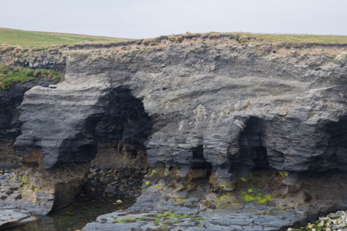
Caves and Arches II. Low tide.
The rocks are all sandstones and shales, as on the mainland, faulted and folded by a disruptive tectonic event nearly 300 million years ago. This alternation of soft and hard layering and extensive faulting has provided many opportunities for selective erosion creating these awesome geological features.

This cave is formed at a fault boundary where soft shale is in contact with hard sandstone

A cave in the early stage of development. Erosion is taking place along a fault and under a sandstone cap. Come back in a few hundred years and this will be a cave.
Sometimes the roof collapses forming what are known as stacks. There is particularly impressive roof collapse which has formed a cave (known as Poul Tabach, a reference to the contraband dealings that went on there), It has created a giant sink hole with two entrances one open to the sea.

A collapsed cave and arch. Poul Tabach. Walled off by the early settlers to stop livestock disappearing down the hole. Said to have been used by smugglers.
On the western side of the island there are many similar caves and arches. I found a number of natural bridges across steep narrow chasms right at the north western tip – in one case a double bridge, something I had never seen before.

Arches and bridges over a steep natural chasm. The bridge in the middle distance is actually a double arch.
As I walked west the sky became thick with those gulls again. I was approaching their breeding grounds. I felt a bit like a cross between David Attenborough and an extra in The Birds, as I skirted around the edge trying as much as possible not to disturb them but at the same time wanting to observe close up this rare experience.

Gull colony with the cliffs of the north west tip of the island in the distance.

Gulls take to the air over the Napoleonic Tower
To my untrained eye there seemed to be two species of gull sharing the same nesting sites. I later identified them as Herring Gulls and Lesser Black-backed Gulls.

Herring Gulls and their chicks

A Lesser Black-backed Gull in flight

Cormorants

An oyster catcher
There were two distinct colonies with thousands in each. One was on exposed rocks with nests on little remnant vegetated patches or just on the bare rock and the other, some distance away with extensive burrows in a field. The dowdy chicks still unable to fly and with their distinctive grey, brown and cream down, scampered across the rocks or hid in their burrows abandoned momentarily by their parents to try and distract me. The more confident ones standing on the cliff edge dreaming of the day they would fly.

Gull eggs. Here they are in a nest but often they are laid on the bare rock.

Two Herring Gull chicks. Ready for their first flight?

Herring gull chick taking refuge in a burrow
I was endlessly fascinated watching this seething mass but there was more to see. Not far away was the tell tale silhouette of a Napoleonic signal tower, so I headed there.
Bearing a superficial resemblance to a Tower House, many call these structures ‘castles’. They are not. They are a part of a network of towers built between 1804 and 1806 as a response to the threat of invasion by the French. There were around 80 towers built along the west and south coast from Malin Head all the way to Dublin. Each cost £3,000 to build.
The idea was that they were within sight of each other (theoretically! Irish weather not withstanding) and in this way a message could be transmitted using flags and black balls on a tall wooden mast. Following Napoleon’s defeat at Waterloo in 1815, the towers fell into disuse. Though solidly constructed many are now crumbling ruins. This one though has many typical architectural features preserved and seems to have been one of the better built ones.

Sea cliffs with caves and bridges and the Napoleonic Tower

The western coast of the Island
It is a handsome building with solid mortared stone walls built of local shale and sandstone but with window surrounds of cut and dressed limestone. Other highlights such as the fire places, the elegant window surrounds and the observation platform buttresses were also of this limestone. Some features were also constructed of red brick. The walls were rendered in a cement with a lot of shell grit The walls were covered inside and out with a mortar of the same material, though only a little remains. The external walls were covered with overlapping slate tiles of which only those on the north-east wall have partially survived. The limestone, bricks and mortar would have been imported to the island. Internally you can see remnants of timber lintels and floor joists. Again presumably imported onto the island. There are many names and dates scratched into the mortar with elegant script and though largely illegible now, most seem to date from the 1800s.

Napoleonic Watch Tower

Red bricks and limestone block were used for some parts

Mortar with shell grit

Fireplace on the Ground Floor

Remains of the timber joists for the first floor

Names carved into the mortar
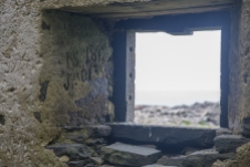
More graffiti

Elegant limestone detail on the window surrounds

The building was faced with overlapping slate tiles. They have only survived on the protected face.
The whole is surrounded by a very solid wall in similar style to the tower and a stone out building. It is perched on the top of a cliff on the highest point on the island and in sight of the Hag’s Head tower to the north and Loop Head (tower now gone) to the south.

Entrance gate and wall surrounding the tower.
These towers are a reminder of the fear that would have engulfed Britain and its colonies at the time and the incredible effort that nations would go to to protect their borders. It is truly remarkable to think that 80 of these towers were built in a two year period in some of the remotest places you could imagine.
My day was rapidly coming to an end. To get back to the pick up point I had to cross a wide expanse of meadow and in places, bog. But first I headed out to the headland at the southern end of the island. Something drew me there. I think it was the cormorants at the point but on the way I pondered a rubbly ridge of stone on the landward side of the headland. Later I discovered this is believed to be the site of an ancient Promontory Fort possibly Bronze Age. You can clearly see this rocky ridge on the google image.

Rocky rubble possibly representing the wall of a promontory fort at the southern tip of the island

Google image of the promontory fort You can see the break where the rubble in the photo above is.
No one really knows what these were used for. But they may have been some sort of lookout. This would suggested habitation before the time of Christianity. St Senan was said to have built a monastery here before going to Scattery. So we are confident it was lived on in the 7th century. Records suggest four monks had an oratory here. It is common for oratories to have a circular wall and there is such a wall at the eastern side of the island. Was this the site of the oratory, long since gone?

Google image showing part of a circular wall which may have been the site of St Senan’s oratory. The hole to the north of this is Poul Tabach.

The circular wall and much later ruined cottages.
It would seem the island is getting smaller as Samuel Lewis in his 1837 book on Clare gives it an area of 210 acres, down now to 185 acres. Historically however it may have been much, much bigger. The island is referred to in The Annals of the Four Masters, (a compilation of Irish history up to 1616) as Fitha Island which included the now separate islands of Mutton Island, Inismattle and Roanshee. This source states that Fitha was connected to the mainland until in 804AD “the sea swelled so high that it burst its boundaries, overflowing a large tract of country and drowning over 1,000 persons.” This is now presumed to have been a tidal wave and it is speculated that it may have been responsible for separating the islands from the mainland. Geologically, this would be pretty unlikely if the connection was of sandstones and shales, however it is plausible, given the extensive glacial deposits still on the island, that if these unconsolidated sediments were the connection with the mainland, then such an event may well have removed some of these deposits. As storm events today still do.
In fact the water between Mutton island and Quilty is very shallow. Anthony, my ferryman, told me that they used to walk cattle across on very low Spring tides. As we returned on the boat he showed me the ‘road’ that lies at the ocean bottom visible in the clear water just couple of metres below. In these very low tides water will reach your knees suitable for cattle. A couple of days later I visited the Seafield shore to see whether I could find it. Sure enough there is a ramp of sorts visible at low tide and in the photo below you can see the trace of the submerged roadway, highlighted in the evening light. It turns out it is in fact clearly visible also on the google satellite image.

View from Quilty to Mutton Island. The ramp to the left is the start of the ‘roadway’ and you can see its trace continuing to the eastern end of the island. You can also see it in the first photo of this blog.

A google image showing the shadow of the roadway at the eastern end.
The island would have had many stories to tell. A ship, the Sao Marcos, from the Spanish Armada, is said to have run aground in 1588 with sailors buried on the island, and it was used extensively by smugglers in later years who took advantage of its many caves. During the days of the Sinn Fein courts, which operated outside the British justice system, it was used as a detention camp.
Further evidence of habitation is in the ruins of some cottages on the south eastern side of the island. It is believed that up to a dozen families lived here in the 19th century, the population peaking in the 1920s. They fished, harvested seaweed, grew potatoes and vegetables, and as the island’s name suggests kept livestock. ‘Mutton Island’ is said to derive from the quality of the meat, flavored by the lush grasses and herbs that the sheep dined on.

Ruins of the village on the island. A home now for the starlings
People lived on the island seasonally until late in the 20th century. One resident led a hermit-like existence there until the mid 50s, living summer and winter for four years. Quite remarkable when you think about it.
As I walked around I saw signs of more recent human activity however. Some fencing. Lobster pots, the remains of a motor vehicle? I had heard a report that one of the residents of the island had built a raft and freighted a Ford Anglia to the island. Was this it?

Recent fencing

An abandoned lobser pot

Recent fencing

An abandoned lobser pot
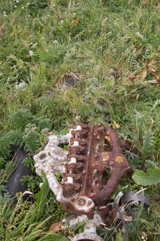
Is the the wreck of the Ford Anglia?

Is this the the wreck of the Ford Anglia?
Mutton island is an island of mystery. I have talked about the archaeological heritage but what about this? I found yhis unique figure in the thick grass around the Napoleonic Tower. Made from the red bricks used in the tower construction. Is it the oldest example of an iconographic emoticon? Predating the digital age by two centuries?

Archaeological heritage? An early emoji.
And then there’s this. A crop circle?

A crop circle?
There is a wide variety of vegetation. No trees. That’s a given, but grasslands, bogland and in places thick growth of thistles and cow parsley that comes up to your chest. Not easy to walk through especially given the hidden rabbit holes!

Fields thick with cow parsley.

Bog cotton
For now the island is populated by rabbits, rats, seals and reportedly goats (though I didn’t see any, so that population may have died out). Doesn’t sound appealing but all the land mammals were introduced from the mainland and are happy in this people-less place. Even less appealing perhaps were the colonies of midges. But, you know, they weren’t interested in me in the least. They were quite happy to dine out on the sweet nectar of the cow parlsey flower.
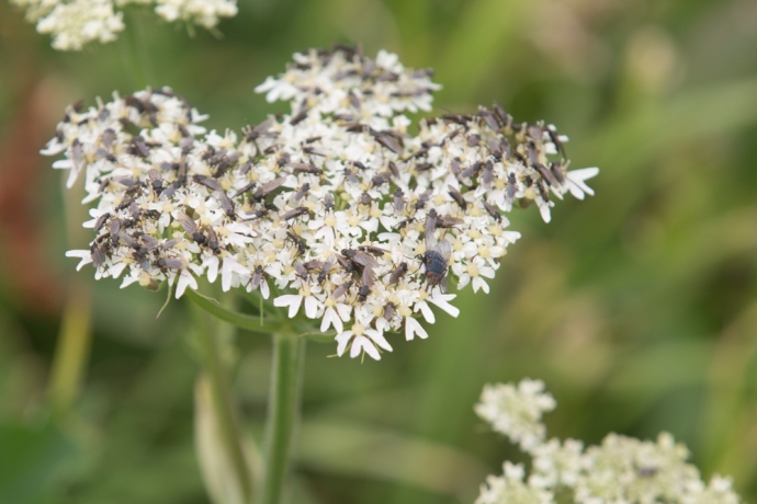
Midges on a cow parlsey flower head. That’s a normal fly for scale.
The island is privately owned and changed hands many times of late. At one time it was owned by the DuPont corporation who thought that it would make a perfect terminal for shipping the oil that was discovered west of Aran Islands. Luckily that plan fell through! An American bought it then and he had grand plans but couldn’t get permission for a pier.
It is a bird sanctuary now and this gives it protection, to some degree, from such avaricious planning decisions, so hopefully it will be there to be enjoyed by those willing to take the trouble and time to get there and who respect its cultural value to Ireland.
This is as it should be.
Around 5 pm Anthony returned in that little red boat, this time finding a shallow beach to pick me up. Reluctantly I re boarded, but the memory of that special place will be permanently etched. Images that will return every time I pull the curtains of my bedroom window to let in the morning light and stare across at that proud rock.

The ferryman returns to collect me

An excellent four part radio series about Mutton Island was made by Raidió Corca Baisicinn in 2016 It’s worth listening to. You can find it at http://rcb.ie/mutton-island/


