Posts Tagged With: Clare

Castlespotting at Caherush, Co Clare.

Caherush Point on the coast of County Clare, was my home in Ireland for over five years.  I walkled its shores many times revelling in its biological and geological diversity and its history; of farming and fishing, and seaweed gathering and quarrying.  I had heard persistent stories of a castle at Caherush Point but  I had never been able to find it or anything of its ruins. I decided to fix that situation before I left and in the week before my departure I went castlespotting.

I had a vague idea of where it was. Indeed the townland name holds a big clue. Caherush is from the Irish Chathair Rois which means ‘castle of the woods’ or ‘castle of the promontory’.  So I looked for a promonontory; any woods are long gone. Through this clever bit of deductive thinking I identified an obvious candidate on a grassy knoll that protruded onto the rock platform at almost its most westerly point.

castle-5498

Caherush Point.  The site of Castle Caherush, an O’Brien family Tower House.

There was little there thought to hang your hat on, until I spotted, half buried and overgrown, the remains of walls built from flat stones with sharp right angles that almost certainly would have been foundations or some sort of retaining wall.  Other flat stones arranged into a wall can be seen at the top of the cliff face looking south from the rock platform.  These are the only evidence of a former tower house, much of which was probably washed into the sea centuries ago on this exposed point.

castle-5507

Parts of walls, probably from foundations of Caherush Castle.  Looking across Mal Bay to Spanish Point.

castle-5462

Part of a wall of flat stones seen from the rock platform looking south.

There is virtually nothing in the historic record.  But we do know the castle was occupied in 1573, as it was then that Turlough O’Brien and twelve men obtained refuge there when they escaped after being badly beaten in a battle with the northern tribes of Clare, led by Teige MacMurrough. I could find nothing else and 19th century archaeologists, such as Westrop, give it only passing mention.

What I found really interesting though is that the site is also the location of a kitchen midden. The castle appears to have been built on top of it.  Kitchen middens, which are essentially prehistoric rubbish heaps are located in a number of spots along the Clare coast especially at Lahinch, Fisher Street and Fanore.  Finds in these middens include hammer stones, scrapers, flints and axes along with shellfish and animal bones. Dating shows these are Neolithic (4,000 to 2,500 BC), though there are both earlier and later middens known.

castle-5396

Kitchen Midden exposed at Caherush Point.  Probably dating from Neolithic times

castle-5509

Close up of Kitchen Midden.  Comprises mostly shells.  One fragment of bone in the foreground.

At Caherush, much of the midden appears lost with only a small portion exposed. Taking care not to cause damage, I had my own little dig and found shellfish, fragments of (animal) bone and even a fragment of a large tooth.  No stone artifacts but this assemblage is consistent with it being of the same age as the other Clare middens.  I took a few photos and carefully replaced and buried the material back in the hole.

So Caherush Point was settled perhaps 5,000 years ago and who knows who has lived at this spot in the intervening centuries. Cattle graze contentedly now over the Point and, with the continuing ravages of the sea, I expect that in just a few centuries, or perhaps even decades, all evidence of the castle on the promontory and its previous occupants will be gone.

Categories: My Journey, Real Ireland | Tags: , , , , , , , , , , | Leave a comment

Scandals & Scoundrels. The Early Days of WA’s Golden Mile.

In a former life I was, for three years, Chief Geologist at the Super Pit,  Australia’s largest gold mine consuming what’s left from undergound mining of Kalgoorlie’s Golden Mile. The richest concentration of gold in the world. Mining has been carried on continuously here since 1893, when gold was first discovered by one Paddy Hannan, from the village of Quin in County Clare.

gm01035

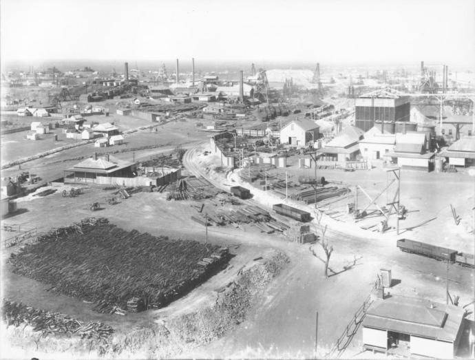
The Golden Mile in 1905.  Photo JJ Dwyer.  WA Museum

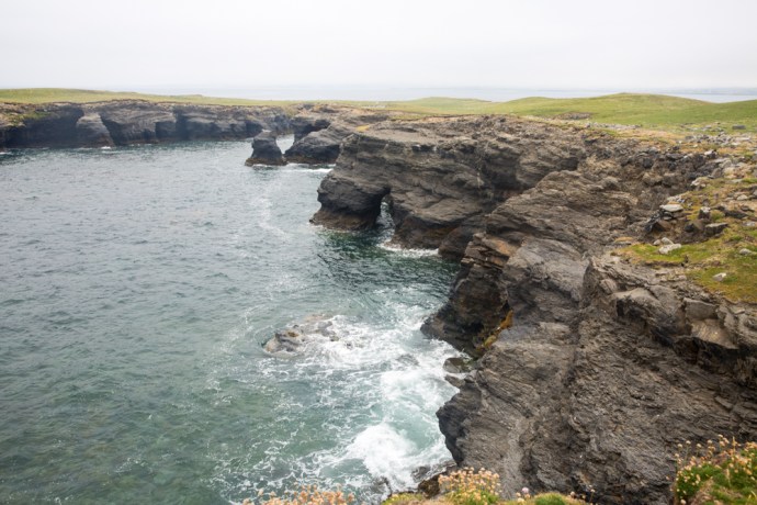
The Golden Mile in 2017.  The Super Pit.  Eastern Goldfields Historical Society

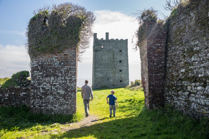
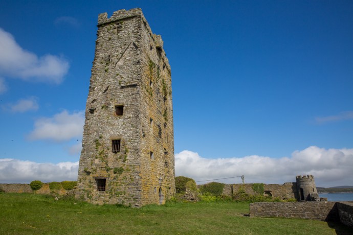
Don’t get me wrong, Paddy was not a scoundrel; I’ll talk about those characters in a bit.  Paddy Hannan led a party of three Irishmen that changed the history of Western Australia, starting a rush that populated the desert and rescued a depressed economy.  There are many reminders of the man – Hannan Street, Hannan’s Hotel, Hannan’s Lager (now sadly defunct) and a statue in the main street erected in the 1920s.  Before the name was changed to Kalgoorlie the place was even called Hannan’s.

paddy_hannan

Paddy Hannan, taken in the mid 1920s.  Photo Battye Library WA.


picture1

Hannan Street, Kalgoorlie, Postcard from 1907.  Coll. Bob Singer

picture2

Crowds gather in Hannan Street, said to have been made wide enough to turn a bullock dray. Coll. Bob Singer

It’s a great story.  Briefly, Paddy emigrated to Australia in 1863, escaping post famine Ireland.  Eventually his six brothers and sisters followed him.  Not an uncommon thing. He started in the mines of Ballarat, but prospecting was in his blood and after limited success in New South Wales, South Australia and the Southern Cross field in WA, he ended up in Coolgardie, the site of the first major gold rush in WA, in 1893.  He was too late there and in June 1893 headed further east into unknown country.

John McMahon takes up the story in ‘Ramblers from Clare and Other Sketches’ (1936).

“At what is now Kalgoorlie, one of their horses strayed. During the search for the horse they found gold in some quantity.  On the nearby ridge of Mount Charlotte they found water, an essential prerequisite for their work. Then Paddy found a series of gullies where gold was clearly visible. Within two days they had unearthed 100 ozs. of gold. [that’s nearly $200,000 worth in today’s value]  Paddy Hannan rode to Kalgoorlie to register his claim and was awarded the space of ground which became known as “The Hannan Award”  [Hannan’s Reward].  News of the find spread like wildfire, within two days they were joined by 400 men and in a week this had grown to 1,000.” 

Prospecting in those days was not for the faint hearted.  Searing temperatures, dust, flies, desert and lack of water and supplies meant many privations.  The well resourced had camels.  Most, like Paddy didn’t, but rewards such as these he, Flanagan and O’Shea found were the reason men (and women) travelled to the remote unknown on the other side of the world.  Paddy was one of the lucky ones.

prospecing-party-coolgardie.jpg

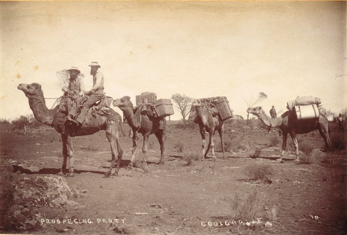
Prospecting near Coolgardie, WA.  Photographer unknown c1894.  Coll Bob Singer

dryblowers coolgardie_unknown

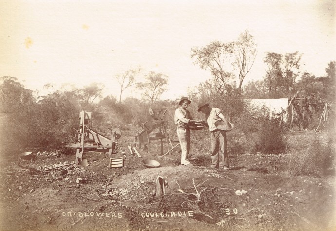
Prospectors using the technique of ‘dry blowing’ to search for traces of gold.  Photographer unknown. c1894.  Coll. Bob Singer.

While Patrick Hannan, Thomas Flanagan and Dan Shea started the rush to Kalgoorlie, they did not discover the real wealth of the Goldfield.  This lay a mile or two to the south and the real hero of the Golden Mile was Sam Pearce,  another emigrant prospector from England.  Just a few weeks after the Hannan’s rush he found the Ivanhoe reef, then the phenomenally rich Great Boulder mine and over the next four months, with others in his syndicate, he pegged Lake View, Royal Mint, Bank of England, Iron Duke, Iron Monarch, Associated, Consols and the fabulous Golden Horseshoe and many more.

Thus began a boom which led to the blooming of the twin cities of Kalgoorlie and Boulder, the railway arriving in 1896 and a monumental water pipeline constructed in 1903 by another famous Irishman, Charles Yelverton O’Connor (from Co Meath).  His achievement of building a 350 mile pipeline from Perth to the desert was one of the great engineering  feats of the day and sadly under intense public criticism of the scheme he took his life before the water arrived.

There was no denying the incredible wealth of the place but from the very beginning  it attracted all kinds of financial speculation.  Inevitably this led to many sharp practices and resulted in a number of financial and corporate scandals which severely damaged the reputation of Western Australia and the Golden Mile in particular.  That’s what I want to talk about here.

It took only two years from Paddy Hannan’s discovery of gold at Kalgoorlie in 1893 for the first speculative bubble to take hold.  The full potential of the finds was slow initially to become apparent.  There was free gold, yes, but most of the gold was locked up in pyrite or in rare minerals called ‘tellurides’, containing the element Tellurium, which formed alloys with gold, making it hard to extract.  Further the gold went deep very quickly.  So the gold could only be extracted by deep underground mining and complicated metallurgical processes.

This need for capital created a massive market for opportunistic floats.  The preferred place to raise money was on the London Stock exchange.  In 1895-6, alomost 700  West Australian gold mining companies were floated.  Some had real ore bodies but most amounted to little more than what we would now call “address pegging”.  So long as the company had, somewhere in the name, a reference to one of the big producing mines or something associated with Kalgoorlie (or both) it was guaranteed success for the promoters.  The most popular name to include was of course Hannan’s.  A quick look at the lease maps prior to 1903 reveals dozens of companies using Paddy’s name linked with some of its producing neighbours to lend some credibility.  Names like Hannan’s Proprietary Dev Co, Hannan’s Paringa GM Ltd, Hannan’s Brown Hill GM Co, Hannan’s Brown Hill South GM Co’,  Hannan’s Star GM Ltd, Hannan’s Reward & Mt Charlotte Ltd, Hannan’s Find Gold Reefs Ltd, Hannan’s Kalgoorlie Ltd.  You get the picture.  None of them had anything to do with Paddy who was long gone.

hannans paringa

Share Certificate Hannan’s Paringa GM Ltd.  1897  Coll. Bob Singer

There were also many “cashbox floats” where large sums of money were raised with no operating mines.  For example the grandly titled Western Australian Gold District Trading Corporation raised £500,000, an extraordinary amount of money.  In today’s terms it would be the equivalent of around $300 million.

wa trading

Share Certificate West Australian Gold District Trading Corporation 1896. Coll. Bob Singer

Despite having no discernable business and no operating mine the company declared a dividend of 100%.  This attempt by the directors  to ensure a high price for the sale of their own shares landed Managing Director Mr L H Goodman with an 18 months prison sentence with hard labour  for “conspiracy to defraud, obtaining money by false pretences, publishing false statement and misappropriation.”

ccf25112012_0001

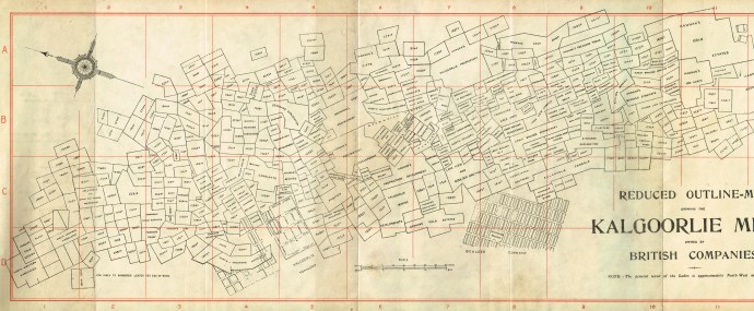
A Lease map of the Kalgoorlie Gold Mines (c1897). Kalgoorlie town is at D4.  Hannan’s discovery is marked as Hannan’s Lode at D3.  The richest mines of the Golden Mile stretch from B6 to B9

The common feature of all these floats, even the legitimate ones, was that of the money raised, most went to the promoters and vendors with very little going as working capital (a familiar story also in later gold booms).

The London market during the ‘Westralia’ Craze was ripe for plucking by over zealous prospectors, wily WA based promoters, less-than-honest Mine Managers and  so-called “experts” all feeding off one another and playing into the hands of unscrupulous London- based promoters and fuelling a frenzy among a rising middle class that we would find hard to imagine today. The only thing remotely similar but on a much smaller scale was the Poseidon nickel boom in WA in the early 70s

This activity prompted prominent author and financial journalist, JH Curle, to comment in his book ‘Gold Mines of the World’, in 1902 that

“West Australia, since the beginning of the mining there, has been a synonym for all that is bad in gold mining” and

“of the boards of directors in London I do not trust one in twenty”.

The climate was ripe for exploitation and none strode the stage larger than Whitaker Wright and Horatio Bottomley.

Whitaker Wright was born in England in 1845 and gained some formal training in chemistry and assaying in his youth. He was active in mine promotion in the US from 1875 and made and lost a fortune before returning penniless to England in 1889. Undaunted, he set to work building up his companies again and by 1897 was a millionaire for a second time!

whitaker_wright_drawing_feb_1904

Whitaker Wright.  Contemporary newspaper sketch c1904.

His return to England coincided with the ‘Westralia’ boom and he was an active participant with his companies – the West Australian Exploring and Finance Corporation  and the London and Globe Company, holding extensive share investments in WA companies.

In March 1897, Wright merged the two companies into the London and Globe Finance Corporation which had an issued capital of £1.6 million and an elite Board of notables ensuring respectability.

london globe

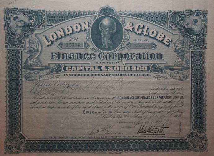
Londond & Globe Finance Corporation Ltd.  1898. Note signature of Whitaker Wright.  Coll.  Bob Singer

The company had considerable real assets including Lake View Consols and Ivanhoe mines on the Golden Mile.  These he used to boost the value of many of the more speculative ventures in the portfolio.

Wright used his knowledge of his mines’ operations to indulge in what we would now call “insider trading”.  He also however engaged in much more sinister activities of market manoeuvring by manipulating output from the mines, especially the Lake View Consols.

picture5

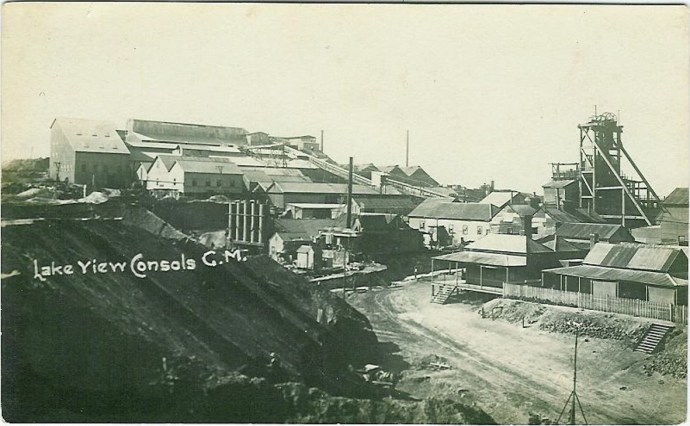
Lake View Consols GM.  The jewel in the Whitaker Wright empire.  Coll. Bob Singer

With the profits from his ventures, Wright became extremely wealthy.  He  acquired over 9,000 acres in Surrey and built  a sumptuous mansion (Witely Park), complete with thirty two bedrooms, eleven bathrooms, landscaped gardens, a private theatre and  an observatory.

article-2058772-0ea3bc5b00000578-595_634x375

Witley Park mansion.  Home of Whitaker Wright’  Including an observatory. Photographer unknown

witley_court_fountain_1897

Witley Park Mansion. Photographer unknown

But most notable of his endeavours was a huge domed glass and steel room under a lake which he constructed.  This is probably one of the world’s greatest follies.   Termed a ‘ballroom’ it was actually used to house a billiard table.  It was said he loved to play in the flickering light that filtered down through the murky water and  the yellow glazed ceiling.

neptune_at_wiltely_park

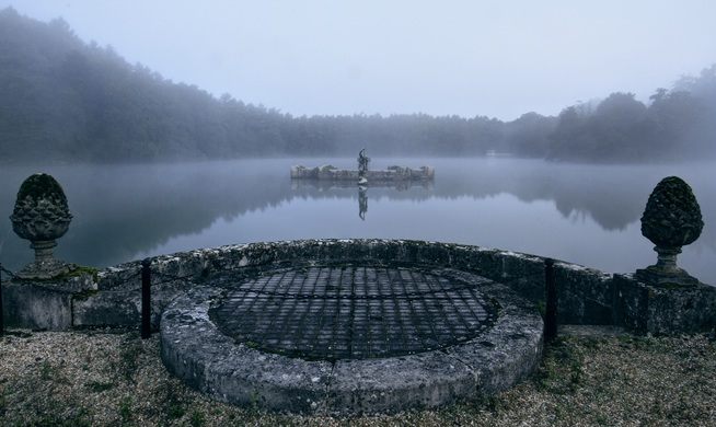
Recent photo showing the top of the ‘ballroom’ in the middle of the lake. Photographer unknown


Off the billiard room is a smoking room-cum-aquarium, where you could puff on a cigar while watching the giant carp.  Atop this is a  giant statue of Neptune, poking above the surface, and appearing as it walking on water.  This folly required 600 workmen to dig out four artificial lakes and remove hills that spoiled the view.

article-2058772-0eb55df800000578-989_306x423

Neptune statue atop the domed roof. Photographer unknown

For Wright, It all came spectacularly undone in 1899 when the Lake View Consols mine hit a rich patch of ore known as the “Duck Pond”. Wright at first withheld a report on the find while he sought to manipulate the market. Then, once it became public, the share price soared to £10 then £20 and ultimately to £28.  Maintaining the share price at these levels depended on maintaining production which could not be done once the shoot pinched out. Whether it was Wright or the Lake View Manager who withheld the vital information that the shoot had come to an end is unclear but the resulting collapse found London and Globe, and many of its shareholders, insolvent as Wright desperately bought shares as they plunged to try and prop up the market.

The clamour for his prosecution grew, especially when official inquiry revealed that the deficiency in his companies totalled about £7.5 million. On hearing this he hid himself in the icehouse at Witley Park for a week, and then fled to New York via Paris travelling under a false name.  Unluckily for him, the technology of the day meant that the warrant for his arrest was ready and waiting when he landed!

Wright was arrested and extradited to London where he faced trial and was found guilty. On 25 January 1904, he was sentenced to seven years imprisonment but before he could be imprisoned he swallowed a cyanide tablet which he had smuggled into the court and was dead within minutes.

The court proceedings revealed a trail of deceit, misinformation and fraudulent accounting all within the framework of company promotions and operations on the stock exchange.  His activities were allowed to prosper because of the complicity and complacency of his shareholders who were happy to receive the benefits of very abnormal profits, without question, relying implicitly on Wright and his directors.

And then there was the wonderfully named, Horatio Bottomley.

Horatio Bottomley was born in London in 1860. He grew up in an orphanage and had no formal training, starting work as an office boy in a legal firm.  His first excursion into company promotion was in 1885 in printing and publishing and he was embroiled in immediate scandal with £85,000 disappearing from the company. Remarkably he was able to avoid charges. In 1888 he founded the Financial Times primarily as a vehicle for promoting his own ventures.

bottomley-trafalgar-square

Horatio Bottomley

Fresh from this triumph, Bottomley got in early in the ‘Westralian’ gold boom on the London Stock Exchange. His companies  West Australian Joint Stock Trust and Finance Corporation and the Western Australian Loan and General Finance Corporation were reconstructed four times each time making Bottomley a fortune. As the boom accelerated late in 1894 he was in the forefront, promoting around twenty companies in the space of just five years. Many companies were floated with worthless leases on the edge of the Golden Mile, often obtaining these leases from the Associated Gold Mines Ltd (which ran the very successful “Australia” Gold Mine) a company of which by a remarkable coincidence,  Bottomley was Managing Director.

australia prospectus

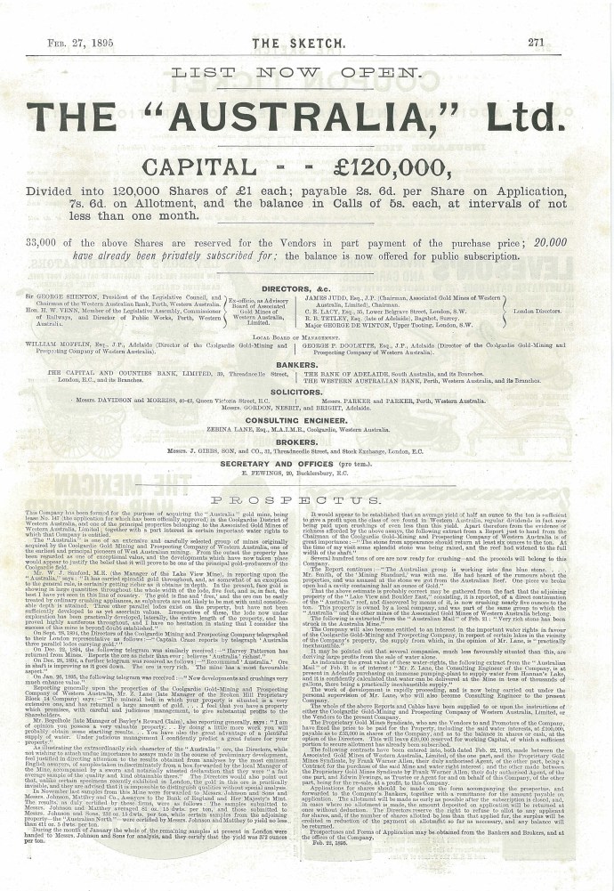
Prospectus for the Australia Gold Mine of which Bottomley was to become Managing Director.  Coll.  Bob Singer

His tactic was to promote to build vendor profits, by pushing the stock price for a short time, issuing a 20 per cent dividend and then letting it decline to liquidation or reconstruction. Thus, almost without exception, Bottomley’s companies were liquidated within a short time with most of the capital going to the promoters

Besides using the vehicle of promotions, Bottomley invested extensively in Associated Gold Mines of Western Australia and in the Great Boulder, companies that gave him a very handsome return as well as lending the appearance of substance to his activities.  Many of his companies included the word “Associated” in their name.

associated financial 1900

One of Horatio Bottomley’s financing vehicles.  Note signature of Bottomley.  Coll.  Bob Singer.

Bottomley’s brief but profitable career in the Australian mining sector of the London market was soon to end. The initial boom had waned and the gold mining industry on the Eastern Goldfields of WA was seeking to develop mining on a large scale.  In July 1897 Bottomley changed tack and floated the West Australian Market Trust which he claimed would have “large and, perhaps, controlling interests in many of the best things in the West Australian market”. However, by the next year it was in serious difficulty with Bottomley losing heavily as the share price collapsed.  Without the equivalent of Wright’s Lake View Consols or Ivanhoe mines in the Trust’s stable, public confidence in it evaporated and by the end of the year Bottomley was forced to reconstruct the company.

Like Wright, he also manipulated production at the Associated mine and stock in the company in order to promote his other company interests and to add to his personal fortunes. Late in the 1890s production at the Associated yielded spectacular results when the mine manager was instructed to stockpile rich ore for strategic processing. In mid-1900 when the deception was clear, it was reported that reserves of payable ore had been overestimated by 75%. As well, Bottomley had successively issued new capital in the company, using part to finance dividends. When production declined and the extent of overcapitalisation became apparent, the inevitable market bears (including his nemesis, our old friend Whitaker Wright) ended Bottomley’s “mining” of this section of the “stock market stope”.

associated southern

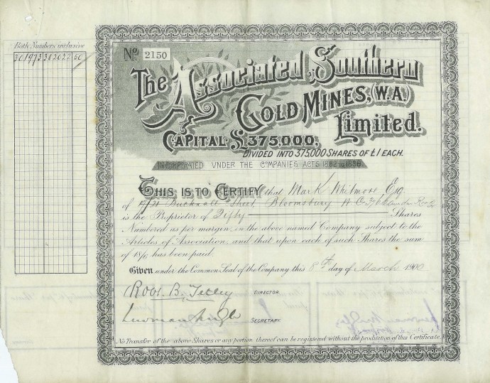
Share certificate for Associated Southern Gold Mines Ltd, a Bottomley company.  Coll. Bob Singer

From 1893 to 1903 it is estimated that Bottomley launched about fifty mining and finance companies with a nominal capital of between £20 and £25 million. His personal wealth at the time was estimated at about £3 million.

Bottomley maintained a superficial respectability as a businessman but remained a superlative con man.  He escaped prosecution for his deeds during this period and later went on to indulge in further nefarious activities which resulted in bankruptcy three times (1912, 1921 and 1928), losing his seat in Parliament (twice) and serving seven years in prison for fraud, eventually becoming an alcoholic and losing everything before dying intestate in 1933.

Bottomley and Wright and a host of other speculative promoters, had negative consequences that hampered the early development of gold mining on the Golden Mile for many years, making it extremely difficult to raise capital for the legitimate operations.  It also set in place a tradition and reputation which continued to be enhanced by the activities of Claude deBernales in the 1930s and Alan Bond and “WA Inc” in the 1980s.

But that’s another story.


Categories: Western Australia | Tags: , , , , , , , , , , , , , , , , , , , , , | Leave a comment

The Raptors at Dromoland, Co Clare.

Dromoland is one of the great castles of Ireland.  Located near Newmarket-on-Fergus in Co Clare, it was for over a thousand years the seat of the O’Brien family. It is now a luxurious hotel with world-class facilities.

raptors-1736

Dromoland Castle, built in the early 19th Century and now a luxury hotel.

It has an amazing history that mirrors that of Ireland.  I could talk here about Donough O’Brien, the first inhabitant of the site in 1014, a son of Brian Boru; or of Murrough O’Brien who gave up his title to Henry VII in 1543 to become the first Baron of Inchiquin; or of Marie Rua, the widow of Conor O’Brien who in 1651 married an officer in the Cromwellian army to keep the castle in O’Brien hands; or of Sir Donough O’Brien, the richest man in Ireland in the 17th century; or of Sir Edward O’Brien who gambled the estate on a racehorse in 1730; or of the construction of the present castle in 1800; or of William Smith O’Brien who fought for the rights of Irish peasant farmers in the famine rebellion of 1848; or of the decline of the Barons of Inchiquin in the early 20th century; or of the saving of the castle from destruction by the IRA in 1921; or of the sale of the castle in 1962 or…

But I won’t.

I want to talk about my walk with the hawks and my visit to the School of Falconry at Dromoland.

My guide on this visit was Damian, flute player, fisherman and, as I found out, expert on all things raptor.  He is one of four falconers at the School.  He introduced me to his charges which included Peregrine falcons, Peregrine-Saker hybrid falcons, Harris hawks and two species of owls, the Irish Barn owl and the Bengal Eagle owl.

raptors-1824

Peregrine falcon

raptors-1835

Peregrine falcon

raptors-1837

Peregrine falcon

raptors-1842

Peregrine falcon

raptors-1801

Peregrine-Saker hybrid falcon

raptors-1806

Peregrine-Saker hybrid falcon

raptors-1875

Damian with a Harris hawk

raptors-1904

Damian with a Barn owl

raptors-1929

The Barn owl.  Wise old man.

raptors-2034

Bengal Eagle owl.  Those incredible piercing orange eyes

raptors-2006

Bengal Eagle owl.  Feeding time.

The Peregrine, on the edge of extinction in Ireland in the 1960s has now recovered and over 400 breeding pairs are known.  A thrill to see them at such close quarters.  The fastest creature on the planet it can fly at 300km/hour as it dives from high above its objective, wings held close, striking and killing its prey, talons ready, with the sheer force of its impact.  On the other hand, the incredibly cute Barn owl is the most widespread bird known, being present on all continents (except Antarctica).  Yet ironically, it is threatened in Ireland as its habitat is progressively destroyed.

Falconry is one of the most ancient activities that man has engaged in, beginning, based on historical records, in ancient Mesopotamia over four and a half thousand years ago; but possibly up to 20,000 years old according to Damian.  Genghis Khan had 10,000 raptors.  One of the Pharaohs of Egypt was buried with 20,000 mummified birds. Falcons were widely depicted in Egyptian art and had profound religious significance. They were also used through medieval times to bring down pigeons, which might be carrying messages to the enemy.  Falconry has survived as a sport to present times and was favoured by the gentry and well-to-do.  Quite a few expressions and words from falconry have found their way into the English language – ‘wrapped round my little finger’,  ‘under the thumb’, ‘bated breath’, ‘hoodwinked’ are examples. Many of these came down to us through Shakespeare.

Such close encounters with these impressive and proud creatures was a special experience.   Damian chose Ophelia, a Harris hawk to accompany us on a walk through the castle grounds.  What a spectacular backdrop as we crossed the manicured lawns, strolled down tree-lined avenues, through ancient woods, past a temple erected to a racehorse, visited a hermit’s grotto and passed the beautiful lily pond.

raptors-2048

Taking Ophelia, a Harris hawk for a walk

raptors-2063

Damian with Ophelia, Harris hawk and the castle as a backdrop

raptors-2093

Ophelia lands talons first

raptors-2111

Take off

raptors-2119

Landing

raptors-2216

Temple of Mercury, erected in the 1700s by Baronet Sir Edward O’Brien. One of Sir Edward’s horses, Sean Buis, is buried underneath.  THe temple is designed so, from a distance, you only see four of the eight legs, so as to resemble a racehorse.

raptors-2296

Damian and Ophelia, outside the Hermit’s Grotto.  This housed a ‘hermit’ employed by the Estate to live there for the entertainment of guests.  They were encouraged to dress like druids and were on display at all times.  One of the ‘worst jobs in history’.


raptors-2324

Ohelia investivates the Hermit’s Grotto

raptors-2319

Damian and Ophelia


The Hawk Hornpipe?

Sculpture by Carmel Doherty.  Perhaps she is playing the Hawk’s Hornpipe.

Ophelia could wander, if that’s the word, freely in the woods until a whistle would get her attention and she would return to the handler’s gloved fist.  Moving so swiftly, flying inches above the ground and swooping up at the last minute to land, claws outstretched and wings spread wide.  A real challenge for the photographer in me. 

raptors-2340

Hawk-eyed

raptors-2377

raptors-2481raptors-2488

Damian let me have a go.  What a thrill to have her swoop in and land so delicately on my fist.    Thanks Damian for capturing me with the raptor so well on my camera. 

raptors-2160

My new friend.  Photo Damian Werner

raptors-2153

Right at home.  Photo Damian Werner

Now through Schools such as at Dromoland all of us can experience birds of prey at close quarters. Highly recommended.

raptors-2552

Categories: My Journey, Real Ireland, Wild Ireland | Tags: , , , , , , , , , , , , | 2 Comments

Sampson Island at Loop Head, Co Clare; You’ve probably never heard of it.

Loop Head is only an hour away from my house near Quilty.  It is one of my favourite places to take visitors no matter what the weather.  So serene and dramatic when it is calm; wild and scary in the wind and rain.  If you have been following this blog you will have seen my earlier posts and photographs. Spectacular cliffs displaying contorted folded sediments, rock arches and caves, a lighthouse, dolphins and in the distance the mountains of Kerry.

IG3C2765

Contorted rocks in the cliffs north of Loop Head

There is a rocky island at the end of the headland which looks like it was sliced off with a giant knife.  It is mad with breeding sea birds through the summer.  The picture below was taken in May and shows just a few early arrivals, taking up prime spots.   A deep and treacherous chasm separates it  from mainland Clare.  As you would imagine, much mystery and legend surrounds this place.

IG3C2820

The island is popularly known by some as Diarmuid and Grainne’s Rock, one of many places in island that reference the famous Irish legend of the love triangle between Fionn Mac Cumhail, his warrior friend Diarmuid and a girl named Gráinne.

The gap to the island is also known as Cú Chulainn’s Leap. And that’s another interesting story in its own right. Here is the short version.

Cú Chulainn was an ancient Gaelic hero warrior gifted with superhuman strength, speed and skill.  He was leader of The Red Branch Knights, who in ancient times would be fighting battles, protecting the folk of Ulster from invaders.  He would, however,  often go travelling.   On one of those trips, he met a ‘cailleach’, translated variously as a wise woman or a ‘hag’. Her name was Mal.  She fancied him and as she had magic powers with which she could ensnare anyone she touched, he took flight.

She chased him all over Ireland eventually following him to this remote promontory in west Clare. He leaped across the channel to the island but she was fairly athletic as well and was able to follow.  Still desperate to avoid her he hopped back to the mainland.  She continued to give chase but she didn’t quite make it slipping on the edge and and ending up in the ocean below. Three days later her head washed up at what became known as Hag’s Head and nine days later her remains came ashore at Quilty. The bay here took the name Mal Bay (hence Miltown Malbay) and the site of the jump became Leap Head or later Loop Head.

All fascinating but I digress.

At the end of April with Spring desperately trying to make an appearance I paid yet another visit. Isn’t it amazing that you can walk past a spot a dozen times and just not realise the significance of what you are seeing?  Well this day I noticed on the cliff edge two metal spikes fixed into the rock and a neat wall and some stone construction above them, including a large stone lined hole.  It all was heavily disguised by the soft spongy grass and the newly budding sea thrift.

IG3C2826

Two Iron spikes fixed into the cliff and a stone wall and hole above.

IG3C2833

Looking from the north to the south

I was intrigued. My first guess was that it was evidence of a former bridge. Perhaps a rope bridge like Carrick-a-Rede, I thought. But why? And in any case, hard as I looked I could see no works on the other side of the island which I would have expected. It remained a mystery but unsatisfied I resorted to Google later that evening.

It didn’t take long to find this truly amazing photo in the archives of the National Library of Ireland.

9148091321_5a53eb9010_o

Viewing Platform Sampson Island.  c1905

What I was seeing was in fact the remains of the foundation of this viewing platform. The  photo is dated at c1905. and reveals a lot. You can see a sign on the Island that says ‘Sampson Island’ and proffers a date in the 1830s suggesting a landing then.

9148091321_5a53eb9010_o-2

Detail of above photo showing sign and shelter.

Did Sampson stake a claim to the island? There is also evidence of a small shelter. Further the people on the lookout are identified by researchers as members of the Sampson family.  But really it is all speculation. Why build this elaborate and hair-raising construction and how did they actually get across to put up the sign?  Why even bother naming it?

Then I saw another image.  God knows how the photographer got this angle

9149347173_f6609352eb_o

Crossing to Sampson Island?

That is one very brave woman in that sling. I am not exactly sure what is going on but it is possible that this was how they got across. There’s quite a crowd waiting to try. Perhaps Mal would have been better off to wait for the Sampsons to build this before attempting the crossing.

With Ireland’s long and convoluted history it is common to come across these hidden stories for which only scant evidence remains. Sometimes though you have to look very hard.  Next time you visit Loop Head have a look for it.  It’s close to the edge though so take care lest you end up like poor old Mal.

IG3C2900

Loop Head lighthouse with the sea pink just starting to bloom

Categories: My Journey, Wild Ireland | Tags: , , , , , , , , , , , , , , , , , , , | 2 Comments

Mutton Island. A Clare Treasure.

This is my longest blog to date.  It is also one I have had the most pleasure writing.  It is about a special place.  Never visited by tourists and only by a handful of locals.  A place where little vignettes of a vanished Ireland can be glimpsed, where nature has done its wonderful work and where you can find peace in solitude.  I hope you find the time to read it and that I can give you a little of this feeling in these words and pictures.  


I live on the edge. Of Ireland, that is.

Every morning I pull the curtains and look out my window across Caherush bay. The first thing I see is Mutton Island. It’s the image that begins every day. Sometimes the cloud or mist or the spray from wild waves hides it and sometimes it is like a green jewel floating on a blue calm. I’ve seen it covered in snow and I’ve seen it bathed in the glow of a West Clare sunset.  But in four years I’d never been there.

IG3C8074-HDR

Sunset over Mutton Island viewed from Seafield Beach at Quilty.

IG3C3546

Mutton Island during the ‘Beast from the East’ in March 2018. Covered in thick snow.

The island of 185 acres is shrouded in myth and mystery. It’s inaccessibility gives these stories weight.

There is no obvious way to get there for those of us who don’t own a boat or a kayak, but I decided one July Tuesday in the midst of an extraordinary spell of hot, fine weather to try and get there.

My inquiries led me to Anthony Murrihy, a Quilty fisherman, and so 10am Wednesday saw me waiting at the Seafield Pier to be ferried across. Well, after two weeks of blue skies, this morning arrived with low cloud covering Quilty and the island. Mmmm. That’s Ireland. Still there was no rain and it was just a bit cooler than it had been which in the end I was grateful for.

As the little red boat pulled away from the Quilty shore, it somehow seemed appropriate that the island should be shrouded in mist. Why would it give up its secrets so easily?

IG3C4150

Anthony Murrihy, Quilty fisherman.  Leaving Seafield Pier.

In my travels around Ireland, I’ve visited many islands: Tory, Inis Oir, Inis Mor, Cape Clear, Sherkin, Valentia, Achill, Aranmore, Dursey, Scattery, Skellig Michael, Garinish. Most are ‘tourist’ experiences. Ferry terminals, interpretive centres, maps and paths, signs with arrows and glossy brochures.  All were wonderful experiences of course, but nothing is like Mutton Island.

So it was just me, Anthony and a little red dinghy heading across the flat Atlantic.  There is no actual landing point on the island and as Anthony tried to hold the boat against a rock with a gaff (made from a paint roller, a broom handle and some duck tape), I gingerly stepped ashore clinging to my camera bag and my egg mayo sandwich.

IG3C4190

The landing spot.  I had to step ashore off the boat onto that rock……

Then it was just me. Anthony and the little red dinghy disappeared back to the inhabited part of Ireland.

It was the strangest feeling watching the tiny speck disappear into the distance. I just stood there for some time, quite dumbstruck.  I really can’t describe it.  A sense of excitement, of respectful awe, and at the same time a creeping solitude. It is so rare to actually be alone and isolated in this ‘civilised’ world. But here I was the only human being on this little slice of the planet. At least for the next few hours.

The island is elongate east-west fattening to the west. The boat dropped me near the eastern end so it seemed logical to start there and circumnavigate the island. This was my kind of exploration. It reminded me of my early days of geology fieldwork. No preconceptions, only a vague idea what I would find and no guide book to follow.  I think now that’s what attracted me originally to exploration geology. Here was an empty, abandoned world. Everything you see is a surprise, no paved path to follow, no interpretive centres or explanatory signs. Just raw nature, landscape, geology, wildlife and archaeology and only your eyes and feet to unravel it.

My first surprise was that it wasn’t the quiet idyll I expected. Because I wasn’t truly alone. The screeching and squawking of gulls and the persistent piping of oyster catchers was overpowering at times. They were telling me in no uncertain way that I was an intruder. Why would they welcome me? This was their world. One gull took a particular exception to me. I was repeatedly dive bombed. Heading straight for my head and only pulling on the joy stick at the last minute to clear me by inches. This was only a taster though. A more Hitchcock-like experience awaited me on the other side of the island.

IG3C4391

Being dive bombed by a gull.

It only took a few strides from the rocky beach though until I realised this was a much more varied landscape than I had imagined. The rolling green slopes that you see from the mainland were there, yes, but hidden from view there were rugged cliffs. Sheer drops and a deeply incised coastline, caves, sea arches, channels and stacks revealing a wildness that was breathtaking.

IG3C4444

The beautiful incised coast at the north eastern end of the island.

IG3C4338

A natural arch on the northern coast

IG3C5467

The sculpted coast exposed at low tide.

IG3C4382

Caves and Arches I.  High tide

IG3C5481

Caves and Arches II.  Low tide.

The rocks are all sandstones and shales, as on the mainland, faulted and folded by a disruptive tectonic event nearly 300 million years ago. This alternation of soft and hard layering and extensive faulting has provided many opportunities for selective erosion creating these awesome geological features.

IG3C5436

This cave is formed at a fault boundary where soft shale is in contact with hard sandstone

IG3C5456

A cave in the early stage of development.  Erosion is taking place along a fault and under a sandstone cap.  Come back in a few hundred years and this will be a cave.

Sometimes the roof collapses forming what are known as stacks. There is particularly impressive roof collapse which has formed a cave (known as Poul Tabach, a reference to the contraband dealings that went on there),  It has created a giant sink hole with two entrances one open to the sea.

IG3C4454-Pano

A collapsed cave and arch.  Poul Tabach.  Walled off by the early settlers to stop livestock disappearing down the hole.  Said to have been used by smugglers.

On the western side of the island there are many similar caves and arches.  I found a number of natural bridges across steep narrow chasms right at the north western tip – in one case a double bridge, something I had never seen before.

IG3C4731

Arches and bridges over a steep natural chasm.  The bridge in the middle distance is actually a double arch.

As I walked west the sky became thick with those gulls again. I was approaching their breeding grounds. I felt a bit like a cross between David Attenborough and an extra in The Birds, as I skirted around the edge trying as much as possible not to disturb them but at the same time wanting to observe close up this rare experience.

IG3C4642

Gull colony with the cliffs of the north west tip of the island in the distance.

IG3C4806

Gulls take to the air over the Napoleonic Tower

To my untrained eye there seemed to be two species of gull sharing the same nesting sites. I later identified them as Herring Gulls and Lesser Black-backed Gulls.

IG3C4697

Herring Gulls and their chicks

IG3C4911

A Lesser Black-backed Gull in flight

There were two distinct colonies with thousands in each. One was on exposed rocks with nests on little remnant vegetated patches or just on the bare rock and the other, some distance away with extensive burrows in a field. The dowdy chicks still unable to fly and with their distinctive grey, brown and cream down, scampered across the rocks or hid in their burrows abandoned momentarily by their parents to try and distract me. The more confident ones standing on the cliff edge dreaming of the day they would fly.

IG3C5236

Gull eggs.  Here they are in a nest but often they are laid on the bare rock.

IG3C4813

Two Herring Gull chicks.  Ready for their first flight?

IG3C4280

Herring gull chick taking refuge in a burrow

I was endlessly fascinated watching this seething mass but there was more to see. Not far away was the tell tale silhouette of a Napoleonic signal tower, so I headed there.

Bearing a superficial resemblance to a Tower House, many call these structures ‘castles’. They are not. They are a part of a network of towers built between 1804 and 1806 as a response to the threat of invasion by the French. There were around 80 towers built along the west and south coast from Malin Head all the way to Dublin. Each cost £3,000 to build.

The idea was that they were within sight of each other (theoretically! Irish weather not withstanding) and in this way a message could be transmitted using flags and black balls on a tall wooden mast.  Following Napoleon’s defeat at Waterloo in 1815, the towers fell into disuse. Though solidly constructed many are now crumbling ruins. This one though has many typical architectural features preserved and seems to have been one of the better built ones.

IG3C4762

Sea cliffs with caves and bridges and the Napoleonic Tower

IG3C5125

The western coast of the Island

It is a handsome building with solid mortared stone walls built of local shale and sandstone but with window surrounds of cut and dressed limestone. Other highlights such as the fire places, the elegant window surrounds and the observation platform buttresses were also of this limestone. Some features were also constructed of red brick. The walls were rendered in a cement with a lot of shell grit  The walls were covered inside and out with a mortar of the same material, though only a little remains.   The external walls were covered with overlapping slate tiles of which only those on the north-east wall have partially survived. The limestone, bricks and mortar would have been imported to the island. Internally you can see remnants of  timber lintels and floor joists.  Again presumably imported onto the island. There are many names and dates scratched into the mortar with elegant script and though largely illegible now, most seem to date from the 1800s.

IG3C4940

Napoleonic Watch Tower

The whole is surrounded by a very solid wall in similar style to the tower and a stone out building. It is perched on the top of a cliff on the highest point on the island and in sight of the Hag’s Head tower to the north and Loop Head (tower now gone) to the south.

IG3C5027

Entrance gate and wall surrounding the tower.

These towers are a reminder of the fear that would have engulfed Britain and its colonies at the time and the incredible effort that nations would go to to protect their borders. It is truly remarkable to think that 80 of these towers were built in a two year period in some of the remotest places you could imagine.

My day was rapidly coming to an end. To get back to the pick up point I had to cross a wide expanse of meadow and in places, bog. But first I headed out to the headland at the southern end of the island.  Something drew me there. I think it was the cormorants at the point but on the way I pondered a rubbly ridge of stone on the landward side of the headland.  Later I discovered this is believed to be the site of an ancient Promontory Fort possibly Bronze Age.  You can clearly see this rocky ridge on the google image.

IG3C5179

Rocky rubble possibly representing the wall of a promontory fort at the southern tip of the island

Mutton island prom fort

Google image of the promontory fort  You can see the break where the rubble in the photo above is.

No one really knows what these were used for.  But they may have been some sort of lookout. This would suggested habitation before the time of Christianity.  St Senan was said to have built a monastery here before going to Scattery.  So we are confident it was lived on in the 7th century.  Records suggest four monks had an oratory here.  It is common for oratories to have a circular wall and there is such a wall at the eastern side of the island.  Was this the site of the oratory, long since gone?

mutton island circle wall

Google image showing part of  a circular wall which may have been the site of St Senan’s oratory.  The hole to the north of this is Poul Tabach.

IG3C4459

The circular wall and much later ruined cottages.

It would seem the island is getting smaller as Samuel Lewis in his 1837 book on Clare gives it an area of 210 acres, down now to 185 acres. Historically however it may have been much, much bigger. The island is referred to in The Annals of the Four Masters, (a compilation of Irish history up to 1616) as Fitha Island which included the now separate islands of Mutton Island, Inismattle and Roanshee. This source states that Fitha was connected to the mainland until in 804AD “the sea swelled so high that it burst its boundaries, overflowing a large tract of country and drowning over 1,000 persons.” This is now presumed to have been a tidal wave and it is speculated that it may have been responsible for separating the islands from the mainland. Geologically, this would be pretty unlikely if the connection was of sandstones and shales, however it is plausible, given the extensive glacial deposits still on the island, that if these unconsolidated sediments were the connection with the mainland, then such an event may well have removed some of these deposits.  As storm events today still do.

In fact the water between Mutton island and Quilty is very shallow. Anthony, my ferryman, told me that they used to walk cattle across on very low Spring tides. As we returned on the boat he showed me the ‘road’ that lies at the ocean bottom visible in the clear water just couple of metres below.  In these very low tides water will reach your knees suitable for cattle.  A couple of days later I visited the Seafield shore to see whether I could find it. Sure enough there is a ramp of sorts visible at low tide and in the photo below you can see the trace of the submerged roadway, highlighted in the evening light.  It turns out it is in fact clearly visible also on the google satellite image.

IG3C7629-Pano

View from Quilty to Mutton Island.  The ramp to the left is the start of the ‘roadway’ and you can see its trace continuing to the eastern end of the island. You can also see it in the first photo of this blog.

Mutton island road

A google image showing the shadow of the roadway at the eastern end.

The island would have had many stories to tell. A ship, the Sao Marcos, from the Spanish Armada, is said to have run aground in 1588 with sailors buried on the island, and it was used extensively by smugglers in later years who took advantage of its many caves. During the days of the Sinn Fein courts, which operated outside the British justice system, it was used as a detention camp.

Further evidence of habitation is in the ruins of some cottages on the south eastern side of the island. It is believed that up to a dozen families lived here in the 19th century, the population peaking in the 1920s.  They fished, harvested seaweed, grew potatoes and vegetables, and as the island’s name suggests kept livestock.  ‘Mutton Island’ is said to derive from the quality of the meat, flavored by the lush grasses and herbs that the sheep dined on.

IG3C5355

Ruins of the village on the island.  A home now for the starlings

People lived on the island seasonally until late in the 20th century.  One resident led a hermit-like existence there until the mid 50s, living summer and winter for four years.  Quite remarkable when you think about it.

As I walked around I saw signs of more recent human activity however. Some fencing. Lobster pots, the remains of a motor vehicle? I had heard a report that one of the residents of the island had built a raft and freighted a Ford Anglia to the island.  Was this it?

IG3C5424

Is this the the wreck of the Ford Anglia?

Mutton island is an island of mystery.  I have talked about the archaeological heritage but what about this?  I found yhis unique figure in the thick grass around the Napoleonic Tower.  Made from the red bricks used in the tower construction.  Is it the oldest example of an iconographic emoticon?  Predating the digital age by two centuries?

IG3C5052

Archaeological heritage?  An early emoji.

And then there’s this.  A crop circle?

IG3C5319

A crop circle?

There is a wide variety of vegetation.  No trees.  That’s a given, but grasslands, bogland and in places thick growth of thistles and cow parsley that comes up to your chest. Not easy to walk through especially given the hidden rabbit holes!

IG3C4490

Fields thick with cow parsley.

IG3C5284

Bog cotton

For now the island is populated by rabbits, rats, seals and reportedly goats (though I didn’t see any, so that population may have died out). Doesn’t sound appealing but all the land mammals were introduced from the mainland and are happy in this people-less place.  Even less appealing perhaps were the colonies of midges.  But, you know, they weren’t interested in me in the least.  They were quite happy to dine out on the sweet nectar of the cow parlsey flower.

IG3C5369

Midges on a cow parlsey flower head.  That’s a normal fly for scale.

The island is privately owned and changed hands many times of late.  At one time it was owned by the DuPont corporation who thought that it would make a perfect terminal for shipping the oil that was discovered west of Aran Islands.  Luckily that plan fell through!  An American bought it then and he had grand plans but couldn’t get permission for a pier.

It is a bird sanctuary now and this gives it protection, to some degree, from such avaricious planning decisions, so hopefully it will be there to be enjoyed by those willing to take the trouble and time to get there and who respect its cultural value to Ireland.

This is as it should be.

Around 5 pm Anthony returned in that little red boat, this time finding a shallow beach to pick me up.  Reluctantly I re boarded, but the memory of that special place will be permanently etched.  Images that will return every time I pull the curtains of my bedroom window to let in the morning light and stare across at that proud rock.

IG3C5516

The ferryman returns to collect me

IG3C7972

An excellent four part radio series about Mutton Island was made by Raidió Corca Baisicinn in 2016   It’s worth listening to.  You can find it at http://rcb.ie/mutton-island/


Categories: My Journey, Real Ireland, Wild Ireland | Tags: , , , , , , , , , , , , , , , , , , , , , , , , | 1 Comment

Spancil Hill is……

I’ve been going to Spancil Hill Fair in Co Clare for five years now.

The Fair has been going for 300 years.  I’ve blogged on two previous occasions (2014.   2015)     So I thought I would do something a little different this time.


Spancil Hill is a spectacle. A melange.
Folk from Ireland and beyond
Travellers and settled; families and bachelors
Horses and donkeys, ironmongery and saddles
Buggies and carts, burgers and fries

Spancil Hill is sticks.
Of blackthorn, hazel, fibreglass or ash
Sticks in earnest conversation
or just to lean on
or to sit on.

There’s a man selling sticks. I bought one.

Spancil Hill is a toddler eye to eye with a pony

Spancil Hill is a runaway pony,
Scared.
Horses rearing.
Until it is cornered and held safely and lovingly in a boys arms.

Spancil Hill is the Irish Cob
How do they see?
Full-maned and feathered, by buyers prodded and stroked.
Mouth pulled open and poked (I’m sure there’s a reason).
Or another pulling a buggy,
or cantering imperiously.

Spancil Hill is John Sheridan sealing the deal on a pied cob.
Slapping hands with the seller.
His family posing proudly for the camera.

Spancil Hill is Sean O’Leary standing with his pony.
Waiting all day for a buyer.
Is it the smallest in Ireland?
For this tiny equine there are many who are keen.
But will they meet his price?

Spancil Hill is a man in a beige suit,
Another without a shirt.

Spancil Hill is lorries loaded with horses.
Headed for Europe.

Spancil Hill is a giant spade.

Spancil Hill is ice creams.

Spancil Hill is John Dooley, a Feakle man sitting in his chair
Since 1946 he’s been there.
It’s his 72nd Fair
The stories he could tell.

Spancil Hill is Aisling and Paddy leading home the newest member of their family

Spancil Hill is Albert and his family selling buggy wheels.

Spancil Hill is Ireland then and Ireland now.

An apposite anachronism.

I love it. 

IG3C1037

Spancil Hill is Sticks.  In earnest conversation

IG3C1181

Or to lean on

IG3C1546

Or to sit on

IG3C1125

Spancil Hill is a giant spade

IG3C1163

Mouth pulled open and poked.  I’m sure there’s a reason

IG3C1408

Spancil Hill is a toddler, eye to eye with a pony.

IG3C1340

How do they see?

IG3C1530

There’s a man selling sticks.  I bought one.

IG3C1459

Spancil Hill is ice creams

IG3C1769

Or cantering imperiously I

IG3C1790

Or cantering imperiously II

IG3C1586

Spancil Hill is John Dooley.

IG3C1892

Since 1946 he’s been there.  The stories he could tell.

IG3C1911

Spancil Hill is a runaway pony

IG3C2005

Until held safely and lovingly in a boy’s arms

IG3C2065

Spancil Hill is a beige suit

IG3C2173

But will they meet his price

IG3C2198

Spancil Hill is Sean O’Leary.  Is it the smallest in Ireland?

IG3C2241

Spancil Hill is Albert and his family selling buggy wheels

IG3C1807

Spancil Hill is John Sheridan. Slapping hands….

Aisling and Paddy and the pony they bought

Spancil Hill is Aisling and Paddy.


Categories: My Journey, Real Ireland | Tags: , , , , , , , , , , , , , | Leave a comment

Oh no! Not more pictures of the Cliffs of Moher.

With all this fabulous weather in West Clare recently I decided to take the cruise from Doolin to visit the cliffs. I’ve been to the Cliffs of Moher many times but never before have I seen them from the water.  I checked the forecast. Fine for the next couple of days.  Brilliant.  So I booked the late boat for the following day as I dreamed of perfect photos lit by the late evening glow.

The morning dawns and I open the window to the bay at Caherush shrouded in thick fog. I wasn’t worried and smugly congratulated myself at my foresight in booking the late boat. The fog will lift of course by midday and there will be blue skies. My optimism was rewarded as it did lift and by mid afternoon some blue sky appeared. A perfect plan?

So I drive the 40 minutes to Doolin.  Around Lahinch the fog starts to roll back in, getting heavier as I drive across the bog and down the hill to Doolin until by the time I reach the Pier visibility is just a few tens of metres. My heart sunk.  Visions returned of a trip to Jungfrau in the Swiss Alps many years ago.  Up the cog railway in a total wipeout.  I saw nothing of the roof of the world.

We set off nevertheless with, in my case, no real expectation.  So much for all those dramatic photos I was going to take of walls of rock framed by skies of blue.

But for fleeting moments as we approached closer the fog would shift and you would get glimpses of green through the grey.  You got a real sense of the powerful presence of these cliffs though you never saw them in their totality and could only imagine how high they actually were.  The changing  views were tantalising and somehow seductive.  As the boat rocked and shifted, the angles changed and I snapped away but with no real hope of capturing this feeling.

I’ve stopped looking for explanations of the Irish version of the way of the world.  An hour later the fog lifted. But never was the expression ‘go with the flow’ more apposite. Taking advantage of the extended daylight in June I spent the remaining hours exploring the rocky coast north of Doolin, in total thrall of the wonderful rock garden that is the Burren in spring.  I forgot about the the Cliffs.

But when I got home that evening (early next morning I should say, after tunes in Doolin and Ennistymon) and looked at the photos and I was surprised and happy at what I had captured.  I still have a lot to learn about photography but I think the images say just as much or perhaps more than if we were seeing every minute and vivid detail.  Sometimes showing just a little reveals a lot.

Turns out that fog was a lucky break.

IG3C6009

IG3C6032IG3C6135IG3C6154IG3C6049IG3C6012IG3C6182IG3C5917

Categories: My Journey, Wild Ireland | Tags: , , , , , , , , , , | Leave a comment

The Fergus. Ennis’ Forgotten River.

Many Irish towns are built on a river. This had obvious logistical, transport and strategic benefits and of course is not unique to Ireland.  Ennis’ name pays homage to this and derives from Inis Cluana Rámhfhada, an island formed by two forks of the river.  That river is the Fergus.  It rises west of Corofin and enters the Shannon Estuary after a journey of 60 km.

One dull April day, with spring making a late attempt to burst through, while I waited for my car brakes to be fixed yet again (one of the prices you pay for being shrouded in salt spray on the edge of Ireland), I decided to walk the Fergus River.  This proved to be more difficult than I thought.

IG3C1240

Fergus River looking south to the bridge at Abbey Street

While the river twists its way through the town, for most of its length it is well hidden.  It struck me that maybe Ennis doesn’t regard it as something to utilise or promote,  just an obstacle to be crossed.  Indeed six bridges cross it and the layout of the town is very much controlled by the loops of the river.

IG3C1535

Bridge at Bank Place looking west.

IG3C1480

Footbridge over River Fergus

IG3C1372

Clon Bridge

IG3C1655

Victoria Bridge

Where you can find it, the banks of the river either have a high stone wall that restricts view and access or are hideously overgrown and littered. Yes I know the river floods but surely space could be found for a park or a bit of open space where you can sit. And if there are seats they are facing the other way or you stare at a wall. You can’t even get to the river at the historic Steele;s Rock.

IG3C1255

Steele’s Rock on River Fergus

IG3C1311

Building on the banks

IG3C1317

River edge on New Street

IG3C1539

Riverside seating.  You need eyes in the back of your head.  Converted cornstores in the distance

In the town proper only very short bits of the river can be approached.  The one exception is the River Walk a part of which is a designated Sculpture Trail.  The walk runs from a car park near the town centre (unfortunately much of the river edge is used for car parking) to the Old Mill and then the short distance to Victoria Bridge. There is quite a bit of interest along the way in addition to the sculptures, including apartments converted from old cornstores, sluice gates and the remains of the Old Mill. But it’s all too short.

IG3C1560

Sculpture ‘Fishy Tale’ by Carmel Doherty on the Sculpture Trail

IG3C1605

Sluice Gates on Fergus.

IG3C1689

Sluice Gates.  Another view.

IG3C1588

Remains of the Old Mill.

If you try and follow the river the other way (to the east), you soon lose access.  It is built up all the way to the Clon Bridge.  Beyond this a small walkway runs parallel to a set of rapids but the weed covered banks seem only useful as a repository for abandoned shopping trolleys.

IG3C1429

Walkway on the Fergus near Clon Bridge.

IG3C1420

Cascades on the Fergus near Clon Bridge.

IG3C1427

Weeds and lost trolleys

I couldn’t help but notice one large area of apparent wasteland between St Coulmba’s Church and the river. There is direct river frontage,  and the geese and ducks seem to be the only inhabitants this time of the year. This would make a perfect Riverside Park. I asked a young traveler lad I met along the path why it wasn’t. “Too boggy” he said dismissively.  Maybe; but if there was a will I’m sure it could be overcome.

Unfortunately I found only one spot in Ennis, near Clon Bridge,  which you could loosely call a park and even it was walled off and paved with gravel.   Anyway just saying. It’s what this town needs.

IG3C1543

Suitable for a Riverside Park?

IG3C2601

A wide area of open land

IG3C2568

with direct access to the river… paddle boats?

IG3C2541

and with a beautiful backdrop


IG3C1437

Open space on the river edge near Clon Bridge.

Lastly there is hardly anywhere to eat or enjoy a coffee on the river bank except The Rowan Tree which is a wonderful exception and maybe O’Briens Cafe.  But again there is a wall. I hear it everywhere though.  ‘Ah, yes but what about the weather?’  but, hey, when the sun shines where do you go?

C’mon Ennis.  Embrace your river.

IG3C1487

The Rowan Tree Cafe.  Riverside dining.


Categories: My Journey, Real Ireland | Tags: , , , , , , , , , , , , , , , , | Leave a comment

Backyard archaeology. Right under our feet. Caherush, Co Clare.

I have spent a lot of my time traipsing around the country exploring archaeological treasures. Ring forts, portal tombs, standing stones, castles, sile-na-gigs, you name it.   I have photographed them and blogged about them. In all that time though I completely forgot to document the archaeology of my own back yard. And I mean literally my own backyard.

In January 2014 Clare, along with much of the west coast of Ireland, was struck with a number of ferocious storm that destroyed beaches and did massive damage to seaside communities. This happened four months before I arrived but the effects can still be seen today.   Hardest hit were places like Lahinch, White Strand, Spanish Point, Quilty, Seafield Pier, Doonbeg, Kilkeee, Kilbaha and Carrigaholt.

In fact the house at Caherush, that was to become mine, was hit hard and inundated, with the then occupants having to be evacuated.

The massive high tides and waves, while doing such obvious damage also uncovered some really interesting things that were previously unknown. For example near Spiddal a ‘petrified’ forest of ancient bog oak was laid bare and, closer to home, a peat layer now covered again was exposed in the bay at Caherush.

This blog is about what was found in the backyard of my cottage after the gravel was stripped away by the waves.  Evidence of long since gone farm buildings was uncovered. A number of different types of paving in close proximity were revealed and these appear to represent the floors of old farm buildings. The site covers 10m x 4m.

IG3C5846

Paving of old farm buildings in the backyard of the cottage at Caherush.

There are cobblestones, setts and flagging, each belonging to a building with a different function.  The original buildings would have been aligned north south. At the southern end an area of cobblestone paving was revealed.

IG3C5852

Cobblestone floor of an old stable.

Cobblestones are one of the earliest forms of paving, the term first being used for roadways in the 15th century in England. The use of cobbles though actually started with the Romans around 250AD. True cobblestones, are small, natural stones with edges smoothed by water, either by the ocean or rivers.  These undressed stones, or cobbles, are often of a flattened egg-shape and were used in their natural state without being worked in any way.  The stones are carefully selected and laid in sand pointy end down and were packed tightly together to provide a relatively smooth and durable surface. This construction has excellent drainage and so they were much longer lasting than the alternative of the time which was dirt. They would also have been used frequently in stables which it is believed was the case here.  A lot of thought went into selecting stones of similar size and shape and in aligning them. It is amazing that it has survived.

IG3C5863

Detail view of the cobblestone paving

IG3C5872

Typical cobblestones selected to be of similar shape and dimensions

Cobblestones went out of favour in the early 1700s and were replaced with setts which are worked into rectangular shapes but still laid the same way. These are actually what people would be most likely to refer to as cobblestone paving now.

So, there is no way of knowing how old this floor is as the tradition of using cobbles may have continued on farms much longer than their use in roadways, especially near the sea. But it could conceivably be pre 18th century,

Next to the cobbles is an area of large irregular slate flagging probably much more recent and representing an access way between the stable and the building to the north. Adjacent to this slate is a beautifully preserved shallow drainage trough made from sandstone setts aligned east west in the direction of drainage. Immediately north of this is a level area of setts in the same rock type and apparently of the same vintage, aligned north south. This area is believed to have housed cattle who would have stood on the level area facing north, which would have enabled the trough to catch their effluent and drain it away. Clever really.

IG3C5883

Cattle shed floor looking from the west.  The drainage trough is in the centre and the area where the cattle stood on the left

IG3C5887

View of cattle shed site from the east.

And then north of this is an area of large flags of Liscannor stone. Mikey Talty who was born in the cottage 80-odd years ago remembers this as a piggery, though he had no recollection of other structures where the cobbles and setts are. The north wall of the piggery had a doorway and this can be seen now filled in in the same style as the surrounding stone wall beneath a lovely stone lintel.

IG3C5854

Piggery floor.  Infilled doorway can be seen.

IG3C5856

Close up of infilled doorway

So there was continued usage of this site to house animals with evidence suggesting the possibility that it may go back over three hundred years.

I think that’s cool. And in my back yard too.

Disclaimer: These conclusions are my own and based on my own observations as well as the recollections of the Talty family. I am not an archaeologist but if anyone out there has specific knowledge of the use of cobbles in farm buildings and their age I would love to hear from you.

Categories: My Journey, Real Ireland | Tags: , , , , , , , , , , , , , , , , , , , , , , , , | 4 Comments

Oysters and Trad Music. And sunshine. Sound like Ireland?

May Day weekend in Ireland is one of the busiest music weekends of the year. There is too much choice and if you live in the west you probably think of going to the Cuckoo Fleadh at Kinvara or the festival at Louisburgh. I am sure the Carrigaholt Oyster and Traditional Weekend does not come into your consideration. Well it should.

To be honest I didn’t even know it existed until I prepared the listing of Festivals, which you can find elsewhere on this blog (A Feast of Festivals) but I decided to eschew the larger festivals and the jam packed sessions and head south to this tiny village.

Carrigaholt is not a name that immediately springs to mind and, in fact, I suspect that many, even Clare, people only have a vague notion of where it is, tucked away in the very south west of the county.  Many visitors come to nearby Loop Head but most, indeed including myself, seem to miss Carrigaholt.

I was attracted by the mention of oysters among other things.  Just love fresh oysters.  Sunday arrived with a clear blue sky and a positively balmy 15 degrees so guess where I went.

Carrigaholt is located on the shores of the Shannon Estuary but is a struggling village, like many in the west of Ireland. Population of the village itself is down to 40 and I am told that of that there are only two children. There are four pubs, a small shop inside one of them, a restaurant with brilliant food and a gift shop. But not much else. Oh, and there is Carrigaholt Castle, one of the most elegant tower houses in Clare, which sits on the water’s edge, and a stunning coastal drive towards Kilbaha with some beautifully exposed geology as well.

IG3C4618

The imposing entrance gate to the Carrigaholt Castle

IG3C4676

Another view of Carrigaholt Castle ruin.  One of the most beautiful in Clare.

IG3C4816

West of Carrigaholt on the Coast Road.  Pink Thrift in the foreground and Loop Head in the distance.

IG3C4825

Gently folded strata.  Looking across to Loop Head

IG3C4840

Stunning scenery on the Coast Road from Carrigaholt

Yet for this weekend the streets were jammed and the pubs crowded. Little local festivals like this are the heartbeat of the traditional scene and mean so much to these isolated villages and I love them. I found myself as possibly the only person in town who had traveled there specifically and who didn’t have some connection to the village. Most were either locals, former residents or family visitors. But I was welcomed fulsomely; like joining a family party as the long lost cousin from Australia.

The weather helped of course. Everything was out on the street. An early so-called Junior Session was the first event of the day. ‘Junior’ is the wrong word. The session was led by members of the Maguire family from Wicklow and the music was anything but kid’s stuff. I was stopped in my tracks by Aiofe Maguire doing a concertina solo that showed a truly phenomenal mastery of the instrument. Playing with her were sister Emma on fiddle and Sean, still only 11, wowing all with his fiery bodhran playing. I had another chance to see them later in the day at the Long Dock.

IG3C4705

The ‘Junior Session’.  Some were more interested in other things

IG3C4697

Aoife and Sean Maguire on the street at  Carrigaholt

IG3C4998

The Maguires perform in front of the Long Dock

IG3C5008

The Maguires

IG3C5017

Robbie Walsh with Emma Maguire

The afternoon and evening was filled with sessions at all four pubs. Mainly local musicians from the district, including members of another talented family from west Clare, the Brownes, with some sensational sean nos dancing in the street from Colm Browne.

IG3C4852

In my element.  Thanks Pat Keating for the photo.

IG3C4861

Sean nos dancing on the street from Colm Browne

IG3C4952

Colm Browne with grandfather Tommy Browne.  A musical dynasty continues

I watched a bodhran workshop on the street led by the renowned Robbie Walsh and his Bodhran Buzz. I had to fight mightily the temptation to grab one and have a go but I resisted.

IG3C4900

Joining in the Bodhran Buzz

IG3C4909

Wherever you can find a seat

And later I joined Clare musicians Geraldine and Eamonn Cotter and their extended family for a marvelous couple of hours of tunes and songs.

IG3C5095

The Cotter family plus

Everyone was clearly enjoying themselves in their own way but for some ice cream was the order of the day.

IG3C5036

Totally absorbed.  A family day out.

IG3C4883

I scream and you scream.

IG3C5158

Let out of the Convent for the day or a very Irish Hen’s Party?  Your call.

IG3C5188

Paparazzi.  Can’t escape.

 The party continued at Keane’s Pub well into the night but after 9 hours of playing I made a quiet exit and left them to it.

IG3C5163IG3C5167

Oh and by the way I got my free plate of delicious local oysters!

IG3C4846

Fiddling with oysters

Categories: Festivals, My Journey, Real Ireland | Tags: , , , , , , , , , , , , , , , , , , , , , , , , , | 3 Comments

Blog at WordPress.com.