Posts Tagged With: Church

Ireland in Four Days (and Five Years). Day 4. Wondrous Wicklow.

I left you at the end of Day 3 with me pulling into a parking bay at Sally Gap in the Wicklow Mountains at around 2 am.  That was my bed for the night.  After a very broken four hours of, what could only loosely be described as sleep, during which my poor little car was buffeted constantly by winds and rain, my hopes (and my reason for spending the night up here) of glorious sunrise shots were somewhat dashed.  The rain had stopped but the hills were lost in mist and only the sheep seemed to be happy.

Sally Gap-3714

Good Morning.  Sally Gap, Wicklow

It was now 6:30 am. I was here now, and sun was predicted to arrive around midday.  So there was nothing for it but to wait.  I walked, I drove and, once my fingers had warmed up I practiced the whistle. And waited at the Roof of Wicklow, until eventually the sun began to make tentative forays.  The plus side of it was that there was a lovely soft light for photographing the hills and valleys, waterfalls and the gorgeous heather and I tried to make the best of that.

Sally Gap-3689

The wild mountain heather in the early morning mist

Sally Gap-3975

Will ye go Lassie go?

Sally Gap-3785

To pluck wild mountain thyme

Sally Gap-3838

All around the bloomin heather

Sally Gap-3857

By yon pure crystal fountain

By 10 am I was rewarded, and I discovered Lough Tay sparkling in the dappled light.  Lough Tay is also known as Guinness Lake (because of its resemblance to a pint of the dark stuff complete with its creamy head).  The sand though is not original.  It was brought in from the coast by the owners (surprise, surprise, the Guinness family).  There is no doubt it deserves its spot as one of the most photographed views in Wicklow.  It is a corrie lake that lies in a glacial valley at the foot of Luggala Mountain.  Luggala Estate, historic home of the Guinness’, is part of the estate and lies in the verdant valley to the north.

Sally Gap--3

Lough Tay, Guinness Lake.  The Guinness mansion (the only building in the picture) is on the far right.

I am glad I waited, but it was time to move on now and I headed on to Glendalough.

The main purpose of the visit was to see the old mine workings.  But as I drove through the tiny village I heard the sound of pipes.  I had to stop.  I stood and listened to the lone piper sitting under a blue sky, next to a spectacular double arched gateway.

Glendlough-3993

Pat Connery, lone piper at the gateway to Glendalough

Glendlough-3997

Singing and playing the pipes is not easy.  Pat Connery at Glendalough

This was Pat Connery and it was beautiful playing, lost for the most part on an unappreciative crowd, who would scurry past, stop to snap a selfie and head up the steps and through the gate, intent on getting back to the bus on time.  I chatted to to Pat, who has been playing this spot for years.  She was using a set of C pipes, which for the uninitiated have a deeper more plaintive sound than the regular concert pitch pipes.  She also sang beautifully, while playing (no mean feat).

Thanking Pat I too headed up those steps.  What I hadn’t realized was that this was the portal to the Glendlough monastic ruins.  In fact it is Ireland’s only surviving example of such a medieval gateway.  I hadn’t intended to stop as I had visited five years ago but hey the music, the sunshine, a warm Irish day; how could I not pop in for another look.  I never posted photos of Glendalough back then because I wasn’t happy with them.  Here was my chance to fix that.

Glendalough is truly special.  Wandering its many sites and catching glimpses of its magic mountain setting will be, despite the fact that half of Europe, America and Asia are there with you,  one of your treasured memories of Ireland.  Even the name is evocative as it comes from the Irish Gleann da locha (Glen of the two lakes)  The site was founded by St Kevin and most of the surviving buildings date from 10th to 12th Century.  That’s old.  Since then it has experienced attacks from the Vikings, the sacking of the monastery in 1214 by the Normans  and its total destruction by the English in 1398.  Reconstruction of some of the ruins was started in 1878 and now you can visit a round tower, seven churches, two High Crosses and much more.  I’m not going to go through all its attractions but I have selected just a few pictures to give you, my readers,  some idea of the extent of these ruins and the calming ambience that you will feel when you are there.

Glendlough-4007

One of the best round towers in Ireland.  Beautifully preserved and original except that the roof was rebuilt in 1878 from stones that had fallen.  Built 10th century.

Glendlough-4052

View of Glendalough past St Kevin’s Kitchen (wasn’t a kitchen) to the mountains beyond.


Glendlough-4035

View of the cathedral, built between the 10th and 13th century.   THe round tower perfectly framed through the window.

Glendlough-4049

St Kevin’s Kitchen I.  It was in fact a church.

Glendlough-4133

St Kevin’s Kitchen II.  Note the corbelled stone roof.  Same technique as used in beehive huts.

Glendlough-4164

Inside the cathedral showing beautiful stonework on the archway.

Glendlough-4064

One of two high crosses.  One is in the Visitors Centre.  This one sits in place in the cemetery.  It is unadorned and known as St Kevins Cross and was carved from a single piece of granite.

Glendlough-4073

The Priests’ House.  Reconstructed from the original stones based on  a 1779 sketch. Compelte with romanesque arch.

Glendlough-4117

Archaelogy at the site continues today with a team at work from UCD.

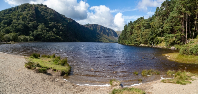
Now I headed to the trailhead for the Miners Way.  It leaves from the eastern end of the Upper Lake where there is a beautiful beach (this time natural I think) and skirts the northern bank.  I had the tall straight timbers of a Scots Pine forest on my right and the deep blue waters of the lake on my left.
Mines-

View from the beach at the east end of the Upper Lake at Glendalough.  Looking west.


Mines-4205

The Miners’ Way walk takes you along the northern bank of the Lake through a Scots Pine forest

As I approached the end of the lake it opened up to a stunning U-shaped valley carved by a glacier 15,000 years ago.

Mines-4226

At the western end of the Upper Lake.  A classic U shaped valley carved by a glacier.

Another kilometre on and the ruins of the mine buildings come into view.

Mines-4274

View of the ‘Mine Village’.  Actually the mine processing plant.

They call it the ‘Mine Village’ but its not really.  It is the ruins of the processing plant the ore extracted from the surrounding hills was processed and the lead and silver removed. No one actually lived here; it is believed the mine workers walked in every day from Larragh a distance of 6 km.  What is preserved here are the remains of the ore dressing floor (dressing is another name for processing whereby the ore is crushed, chemicals are added that assist in separating the ore from the waste, and then it is filtered and dried).  The most prominent building is the ruin of the the Cornish rolls crusher house, built in 1855. Part of it was recently rebuilt in an effort to forestall further deterioration.  The rolls crusher mechanism itself is well preserved and lies a short distance away on the valley floor.  It is such a thrill to wander round these ruins. 

Mines--3

View of the crusker on the left and mine buildings on the right.  Old shafts and mullock heaps can be seeon on the ridge,  A tramway (nothing remains) brought the broken ore to the crusher

Mines--2

A view of the mine area from the west looking up the Upper Lake.  The white heaps are tailings (material  that remains after the valuable minerals are removed)

Mines-4343

The Cornish Rolls Crusher building

Mines-4405

It is said that this is the best preserved example of a Cornish rolls crusher in Ireland. 

Mines-4277

Tailings from the Glendalough processing plant.  Timbers in centre of picture are believed to have supported the tramway used to transport ore from the mine shafts.

Mines-4361

A specimen of lead ore showing galena.

Mining also took place in the Glendasan Valley to the north of Glendalough on the other side of Camaderry Mountain.  The main mineral vein cuts through the mountain between the two valleys and mine workings along the veing connected the two valleys.

So I had to go and have a look there.  Another beautiful U-shaped valley greeted me.  This time however we are at the top of the valley where there are the remains of another ore dressing plant.  I can see other mines in the distance and on the mountain sides so I followed the river downstream. 

Glendasart-4510

Glendasan Valley.  View down the valley from the ruins of the Hero Mine processing plant

Unfortunately the telltale evidence of historic mining along the river does not tell a pretty story of environmental responsibility.  Much of the mining is very old, nearly 200 years, so I suppose that is some excuse, but some dates from the middle of the 20th century when they should have known better,  Tailings and waste stockpiles are scattered along the river valley and, in places, the river flows right through them or has found a path around them.  Considering the high levels of lead, one can only speculate on what this has done to the water quality.  There is no way approval would be given for a mine treatment plant to operate on the bed of the river theses days.           

Glendasart-4517

Glendasan Valley with tailings and mine spoil in the river bed

Glendasart-4524

Glendasan Valley 

Glendasart-4530

Mine workings on the north side of the Glendasan Valley and the processing plant ruins on the river bed.

One last story that I came across during my reserch.  With the increase in the mining workforce in the 1850s,  demand for housing increased and the mining company built some houses for their workers. One row of houses close to the mining works is said to have once housed eight musicians and was thus given the name ‘Fiddlers Row’.  Love it.

Fiddlers_row_web

This row of houses was built in the 1850s and housed mine workers.  Due to the number of musicians it was known as Fiddler’s Row.

After walking maybe 10km around these two sites I was totally exhausted and a bit of a chill was coming into the air so well satisfied, I decided to end my jaunt here.

Glendasart-4550

The unusual bridge across the Glendasan River

A four day journey across the country and through 5,000 years of history.  Thanks for coming on the trip with me.  I hope I have planted a little seed for those who have never been here and for those who know this place well, maybe I have given you some new ideas or a changed perspective.

For the time being that is the end of my travels in Ireland.  But there will be more.  Ireland’s like that – you keep coming back.  Try and keep me away.

Categories: My Journey, Real Ireland | Tags: , , , , , , , , , , , , , , , , , , , , , , , , | 1 Comment

Burren Stories #1. Corcomroe Abbey

I can’t believe that in the five years I’ve lived here I hadn’t come across this place before. It wasn’t until I was chatting to my friend Oliver O’Connell, a man who knows the Burren as well as anyone, that it came up in conversation. When he saw the blank look on my face, he said “let’s forget about our plans. I’ll show it to you”.

It is hard not to be impressed when you first see it. A stunning location in a green valley surrounded by the treeless rocky hills it has towered over the landscape for centuries. A huge symbol of Church and Chieftain power. Surrounded by natural beauty and itself the stuff of legends.

cormcroe-6633

Corcomroe Abbey in its fertile valley

cormcroe-6644

Another view of Corcomroe Abbey bathed in sunshine.

cormcroe-5731

Corcomroe Abbey viewed from the east. Note the repaired roof over the nave

It was founded for the Cistercian monks around 1195 and the church we see today was constructed in the early 13th century. The name is said to have derived from Corcamruadh, cor meaning district; cam, quarrel and ruadh, red. The church was also dedicated, more poetically, to St Mary of the Fertile Rock. It is believed that the building was commissioned by King Conor na Siudane Ua Briain (Conor O’Brien) King of the ancient territory of Thomond and a huge benefactor to the Church.

The continual relationship and support of the ruling families meant for a turbulent history for the monastery and led ultimately to its downfall. Many battles were fought in and around the Abbey and its ownership regularly changed hands. In 1268 Conor O’Brien was killed by Conor Carrach O’Loughlain, though the O’Brien’s maintained control. The monks retrieved his body and interred him in the Abbey. In 1317 yet another battle was fought this time between factions of the O’Briens and the Abbey was used as a barracks. By the end of the 14th century, the O’Cahans (O’Kane or Keane) from Derry took control of the Abbey’s lands. Sometime in the 15th century (though it is unknown how) the Tierney family took control.

With the dissolution of Catholic monasteries due to the English Reformation the Abbey and land was granted to the Baron of Inchiquin and Earl of Thomond, Murrough O’Brien, in 1554 and then in 1702 to Donat O’Brien of Dromoland, whose family retained the abbey until the 1870s when it passed into public hands.

Meanwhile the monks continued to tend the fields and maintain the abbey as circumstances allowed, but the political climate led to continued decline until the last abbott was appointed in 1628.

It is built to a standard Cistercian plan, though with some notable variations and the extreme decoration is unusual. The stonework is of such high quality it is said to have led to the ultimate demise of the five stonemasons involved, who were executed by O’Brien to prevent them repeating their masterpiece somewhere else. Hopefully they got their reward in the next life.

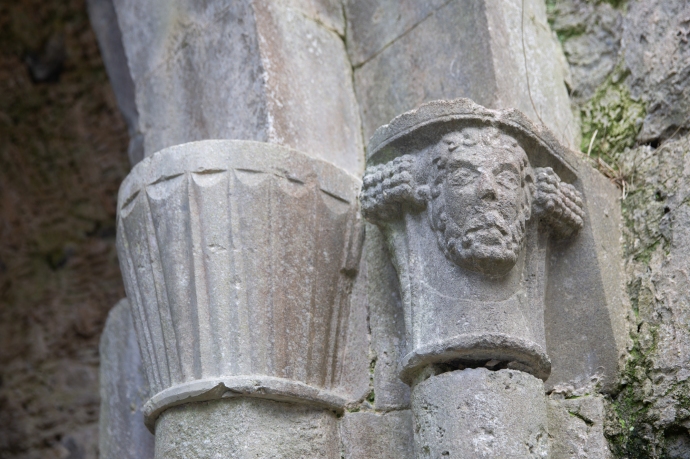
Over the nave there is a roof (repaired very sensitively) with exquisitely carved rib vaulting with herringbones and some floral decoration. It is lit by three lancet windows. Either side of the nave are columns with detailed carvings of human heads and flowers. Including what look like bluebells and fleur-de-lys. What is intriguing to me is the lack of symmetry of these decorated columns. This lack of symmetry is seen elsewhere, for instance in the arch over a niche on the north transept. Was this intended or was it a result of different masons working on different areas or maybe a thumbing of noses to architectural orthodoxy? At the base of the columns are further carvings of flowers (?). One intrigued me. It is unidentifiable, though to me it looks remarkably like a map of Australia which wouldn’t be ‘discovered’ for another 550 years! Such prescience.

There are many other notable features in the nave. A niche tomb on the north wall houses a life size effigy of Conor O’Brien. Beautifully carved it is one of the few examples of a depiction of an Irish chieftain surviving. He is in a serene repose, wearing a robe with pleats and a crown with fleur-de-lys decoration. He once held a sceptre apparently in his left hand (now gone) and his right holds a reliquary suspended round his neck. Love the little touch of his feet resting on a cushion. Love also that we are able to see it in situ, with no guard rails rather than have it relocated to a museum somewhere. Above this is a detailed carving of a bishop. There is an intricate sedilia (where the priests sit during the service) on this same wall.

Where the north and south transepts intersect the presbytery, there are several crossing arches in remarkable condition and set into the floor throughout are grave slabs. I am a lover of gravestones and here are some of the finest I have seen in Ireland, especially those close to the altar (where the rich were allocated space). And some of the oldest, with one I saw dating back to the late 1600s. This I think reflects the patronage by the elite who could afford intricate engraving that has survived.

cormcroe-5699

Corcomroe Abbey. Archway over niche in north transept. Note again assymetrical carvings with bluebells on left and fleur-de-lye on right.

cormcroe-5687

Corcomroe Abbey Carved head on right hand column in southern transept

cormcroe-5685

Corcomroe Abbey. Carved head and flowers on left hand columns in the south transept

cormcroe-5674

Corcomroe Abbey. Effigy of Conor O’Brien.

cormcroe-5662

Corcomroe Abbey. Grave slab. Elegant simplicity. Pray for the soul of Martin Burke and Posterity 1775

cormcroe-5659

Corcomroe Abbey. Oliver O’Connell examines a grave slab

cormcroe-5653

Enter a cap

n

tio
cormcroe-5640

Corcomroe Abbey. Grave slab for John O’Dally and Marey Flanagane. Dated 1682. The oldest I saw.

cormcroe-5627

Corcomroe Abbey. Double arch over sedilia on north wall of nave. Different decorative carvings on each column

cormcroe-5623

Enter a caption

cormcroe-5622

Corcomroe Abbey. Beautiful detailed carving of a bishop

cormcroe-5620

Corcomroe Abbey. Tomb niche of Conor O’Brien underneath carving of a bishop.

cormcroe-5612

Corcomroe Abbey. Unidentified carving. Map of Australia?

cormcroe-5609

Corcomroe Abbey. Floral carving at base of columns.

cormcroe-5607

Corcomroe Abbey. View of the columns supporting the arch over the nave. Note the assymetrical arrangemetn of carvings at the tops of the columns.

cormcroe-5596

Corcomroe Abbey. Looking towards the nave showing the arches over the north and south transepts

A walk around Corcomroe is almost spiritual. You do feel some sort of presence. And it is not surprising that stories of this abbey are woven into Irish Culture in many ways other than the clinical history of battles and chieftains or its marvellous architecture.

Indeed it is said to be haunted by the ghosts of a poet named Cearbhall O’ Dalaigh and Eibhlin Kavanagh who eloped in the 15th century and wished to be secretly married at midnight on Christmas Eve. If you know the song Eileen Aroon, which is about this episode, then you know that it didn’t end well as Eibhlin’s father caught up with them that night.

You will also feel perhaps, when you walk around, the inspiration that Yeats must have had when he chose to use it as the backdrop for his play on Irish freedom, The Dreaming of Bones.

That feeling stayed with me long after. Thanks, Oliver, for introducing me to this special place. Highly recommend.

Categories: My Journey, Real Ireland | Tags: , , , , , | 1 Comment

The stunning beauty of Harry Clarke’s windows. St Barrahane’s, Castletownshend, Cork.

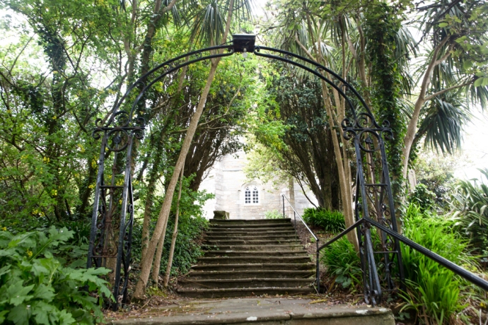
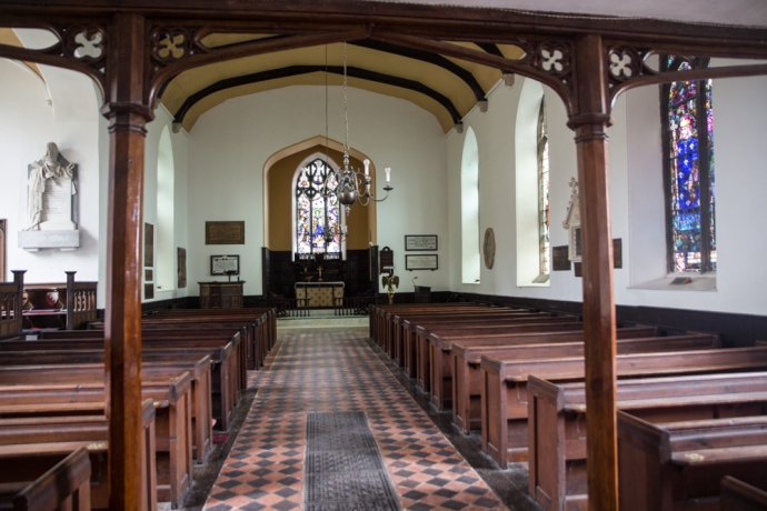
Eight kilometers from Skibbereen in West Cork is the village of Castletownshend, the historic seat of the Townshend family.   St Barrahane’s Church, built in 1827, sits on a hill above the village. It is accessed by 52 steps. One for each Sunday of the year. It is an elegant building with many original interesting architectural features and some fine detailing, both internal and external, including timber paneling and an organ gallery.

IG3C2752

St Barrahane’s Church

IG3C2660

The last 13 of the 52 steps to the church

IG3C2664

Simple and elegant interior

IG3C2722

The organ gallery

Of greatest interest though to visitors is the addition in the early 20th century of six magnificent stained glass windows.

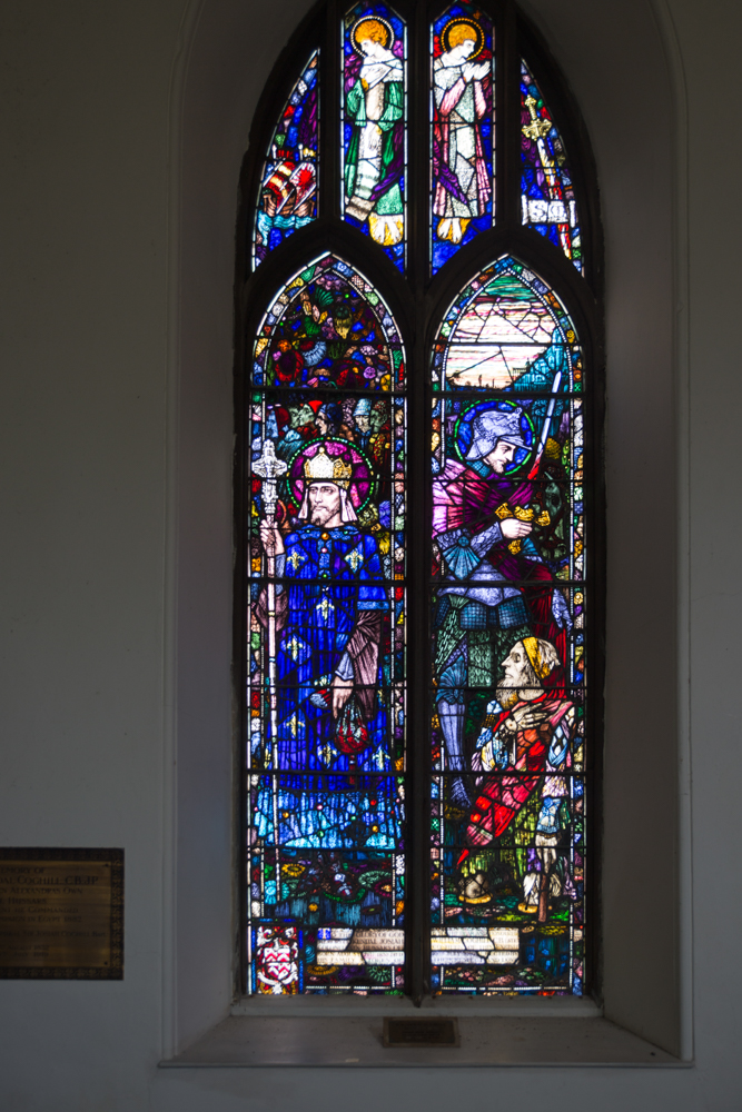
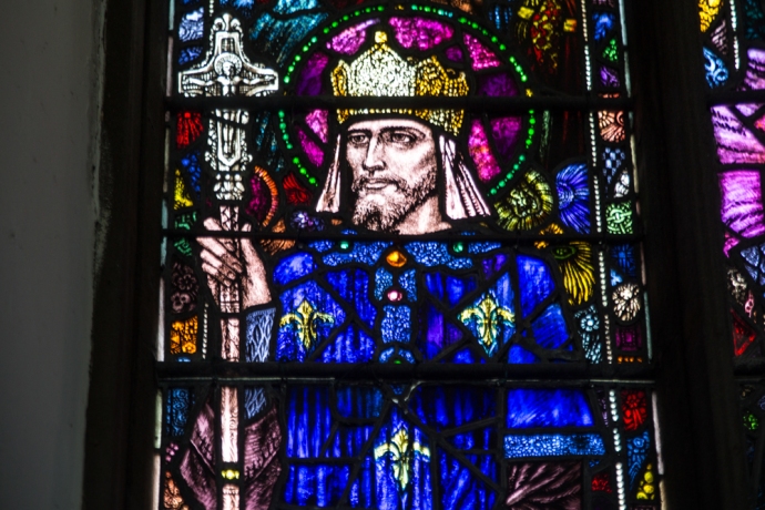
Three of these are by Harry Clarke, a book illustrator and Ireland’s most famous stained glass artist, who died in 1931, and three are by Powells of London. It is not hard to pick those by Clarke.  They are characterised by beautiful, finely crafted, elongate figures and his use of deep rich colours. the wall to the right of the altar has three windows with the Clarke window, on the right, being quite distinct and obvious.

IG3C2734

The Harry Clarke window is on the right.

IG3C2665

The Louis and Martin window by Harry Clarke

This window depicts French Saints Louis (who was Louis IX, King of Spain) and Martin and was commissioned in memory of a Colonel Coghill in 1921. A window of two lights, the first light depicting St. Louis who was an ancestor of the Colonel. The figures above his head represent the poor who he often fed at his table. The first of the tracery lights depicts a ship in which King Louis sailed to the east to fight the infidels. The second and third tracery lights depict two angels who offer protection to both saints. The fourth tracery light shows St. Martin’s flaming sword, denoting his patronage of soldiers,  The second light depicts the meeting between Saint Martin of Tours, dressed as a soldier’s garb, and a beggar who asks him for clothing.  Again the imagery is imaginative, stunningly crafted and in glorious deep colours.

IG3C2668

Detail of St Louis

The largest window, known as the The Nativity window, was commissioned in 1917 in memory of the Somerville family.  This window has three lights, with separate depictions of the shepherds paying homage to the Christ child, the holy family and the magi but with linking elements such as Mary’s dress and the crib that create a unified picture. They are exquisitely decorated in shades of blue, pink, green, red, purple, magenta and gold. The tracery lights depicts three saints, Brigid, Fachtna and Barrahan in gorgeous detail.

IG3C2705

The Nativity window

IG3C2709

Detail of the Nativity window

IG3C2713

The three Saints in the Nativity window

When you look at these windows from outside the church, you can have no expectation of how stunning the images are when back lit.

IG3C2751

The Nativity window from the outside

If you a visiting West Cork you really must take a peek. Or look for Clarke windows in Dublin and many other locations in Ireland and England.

He completed over 130 windows.  You can find where they are here  https://en.wikipedia.org/wiki/Harry_Clarke

Categories: My Journey, Real Ireland | Tags: , , , , , , , , , , , , , , | Leave a comment

Scattery Island, Co Clare. An Irish Time Capsule.

At the southern end of West Clare, on an island just off the coast near the town of Kilrush, lies one of country’s best kept secrets.  But that’s changing. The word is out. Last year it was awarded a prestigious European Destination of Excellence award for Ireland for offering a ‘tangible cultural experience’ and visitor numbers are dramatically increasing.  In 2016 870 people visited the island.  This year they are expecting up to 6,000 people.

Before 2016 visiting the island was unpredictable.  If there was enough interest then a boat trip was organised.  That changed with the setting up of Scattery Island Tours two years ago.   They have just commissioned a spanking new ferry that comfortably accommodates 70 against the old one, which took 12, and this is certainly helping  but don’t let that put you off.  I spoke to Irene Hamilton, one of the principals of the company, about the her desire to open the island to a larger audience and at the same time preserve what it is that makes it special.  The island has so much to offer and you can tailor the experience to your own needs.  Join a guided tour and have the stories of the island explained or explore on your own.

Irene comes from a line of island residents.  Her father was born on the island and was a sea pilot as was his father.  This link and the remarkable foresight of the people of Kilrush has put the Company at the forefront of placing Scattery  as one of the must-see destinations of Clare.  Her vision is that visitors don’t just zip past on the way to Loop Head but stop overnight in Kilrush and explore the place at leisure.

So why is it special?  There’s actually nothing else like it.  A now uninhabited island with a continuous occupation that started over 1,500 years ago, beautifully preserved, easily accessed and in a spectacular location.

I had been trying on and off for a while to get onto the island but it just never happened. During an unusual warm spell in late May I tried again. The Gods were smiling this time and on a bright blue Thursday I boarded the An Breandàn for the short trip across the channel from Kilrush.  Irene told me that the boat was named for her father and it is no coincidence that Breandàn is also the patron saint of the sea.

IG3C6864

Boarding the ferry to Scattery

Actually the most time consuming part of the journey was in the lock at the entrance to the Marina. It was fascinating to see the water rush in as the gates opened to maintain the level in the Marina

IG3C7484

Water enters the lock

IG3C6919

Irene Hamilton, owner of the ferry company chats to patrons.

Once through the lock you see the island and its signature Round Tower rapidly approach you and in less than 15 minutes you are there. We were well looked after by  the efficient and friendly crew which included Irene’s sister Martina.  Irene was a mavellous host spending much of the time, when she wasn’t performing seafaring duties, chatting with patrons and and answering questions or helping with family photos or making cups of tea.

IG3C6922

Approaching the island.  The Round Tower dominates.

IG3C6968

The view from the pier,   The white cottage on the left is the Visitor Centre, Keane’s Castle is in the centre and the Round Tower can be seen in the distance.

When we arrived we were handed over to  Michael who acted as our guide. The guides are provided by OPW who manage the island.  They also maintain a small visitor centre.  The tour is roughly an hour and you visit all the monastic and archaeological sites with the exception of the lighthouse and the Battery.  This was certainly worth it as Michael has a wealth of background knowledge that fleshed out the story.   Next time however I will explore it on my own but I would certainly recommend the tour as a first time experience.  And anyway it’s included in the price of the ticket.

IG3C7004

The guided tour begins

The story of Scattery starts with the birth of St Senan, in 488AD in Molougha, a townland about 5 km from Kilrush in Co Clare. After a life of religious study including time in Rome he set up a monastery on Inis Cathaig in 532AD.  This is the original Irish name and over time it became anglicised as Scattery.  The name relates to the presence of a monster known as the  “The Cathach” which was said to inhabit the island.  On Senan’s arrival he apparently faced the monster and ordered it, in the name of the Trinity, to depart. Such was Senan’s power that The Cathach obeyed and retreated to Doolough Lake at the foot of Mount Callan.

Little is known of Senan’s life or life under him in the monastery.  Many miracles are attributed to him however and his grave has continued to hold a sacred place among the people of West Clare and beyond. The grave is supposed to be the site of miraculous cures.  Stones from St. Senan’s Bed were regarded as relics and a protection against diseases and especially drowning.  Water from St Senan’s Well had restorative powers.

We do know his rule on the monastery was austere and women were banned from even setting foot on the island.  St Senan died in 544, but it would appear that the monastery continued unimpeded until the arrival of the Vikings in Ireland in 795.  Scattery which lay on their route to Limerick was sacked between 816 and 835, being severely damaged. In 968 the Vikings were expelled from Limerick by Brian Boru and retreated to Scattery. Boru however pursued them and three years later the island was raided with up to 800 people being slaughtered.

In 1057 the Vikings had another go with the Dublin Danes plundering the island. Then again in 1101 Magnus, king of Norway attacked. The Normans arrived in 1176 and this led to an attack by William Howell, not even sparing the churches.  By 1189 the last Bishop of Scattery had died and the Diocese of Scattery was abolished. The English  now took possession of the island.  The end came however following the 1537 introduction of  the Suppression of the Monastries Act by Henry VIII.

Phew! That is some story.  It seems to have been touched by every major historical event that Ireland experienced.  There are many reminders of this tortured time in the ruins that can be seen on Scattery.  Churches that date back as far as the 8th century, the round tower built between 10th and 12th century,  St Senan’s well,  St Senan’s Bed.  I found this all totally absorbing.  Come with me on a virtual tour.

IG3C7082

St Mary’s Cathedral and Oratory.  Built in 8th Century and added to until the 15th century. The Round Tower in the distance.

IG3C7085

The eastern window of the Cathedral.  The carved stone head is said to be St Senan.

IG3C7104

View of the Cathedral from the west.

IG3C7165

Western doorway of the cathedral.  Note the tapered shape of the door under the heavy lintel.  The stone to the left is thought to be a balaun stone.

IG3C7217

A distant view of the Round Tower and the Cathedral.

IG3C7096

The Round Tower built between 8th and 10th Century. Note the unique doorway at ground level

IG3C7141

View from inside the Round Tower

IG3C7146

The Round Tower doorway.  Note the thick walls; over 1 metre.

IG3C7237

St Senan’s Well. During a drought St Senan prayed for water and an angel guided him to this spot.  The Sanit plunged his staff into the ground and water sprung forth.  


IG3C7166

Distant view of Cnoc an Aingeal (Hill of the Angel), One of the earliest surviving churches built on the site where Senan set foot on the island.


IG3C7188

Remaining early wall of the church on Cnoc an Aingeal.

IG3C7257

St Senan’s Church.  12th Century Romanesque style

IG3C7292

St Senan’s Bed, a small church built over the grave of St Senan.  The iron bar is supposedly designed to keep women from walking in.  Women who entered according to tradition will be cursed

IG3C7262

View of the Round Tower from the entrance to St Senans Church

IG3C7280

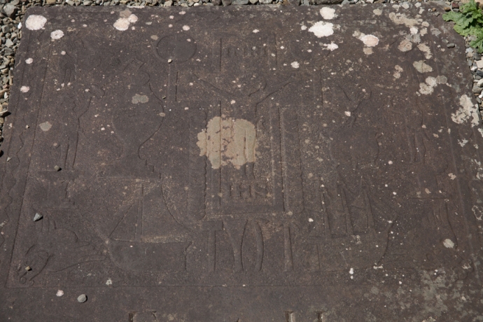
A stone table found near St Senans Church.  Thought to be a medieval grave slab carved with a beautiful celtic cross and with an inscription saying Or Do Moenach Aite Mogroin. (Pray to Moenach the teacher of Mogroin).

IG3C6999

Teampall Na Marbh (Church of the Dead). Built 14th and 15th Century.

IG3C7037

View across the graveyard of the Church of the Dead towards Cathedral and Tower

IG3C7032

Modern graves at the Church of the Dead

IG3C7449

The graveyard at the Church of the Dead continues to be used for burials.

But the island’s story did not end with Henry.  Its strategic position meant it was always in the centre of events.  The ruins of Keane’s Castle, a tower house constructed in the late 1500s can be seen at the pier.  The driver at this time was the invasion by the Spanish Armada and the Irish Rebellions which threatened English rule. Remains of gun installations are evident.

IG3C7477-Pano

The ruins of Keane’s Castle, a Tower House built in the late 1500s

The next phase of activity on Scattery though did not begin until the end of the 18th century. The French supported the Irish Rebellion in 1798 and in 1814 the impressive Artillery Battery was built by the English as part of the extensive defenses erected on the west coast of Ireland. Unfortunately I did not get to visit this time.  Or the lighthouse which was built later in the 19th Century.

IG3C7176

View of the lighthouse and Arillery Battery from Cnoc an Aingeal

In the early part of the 19th century secular settlement of the island picked up with the construction of a village to house families of river pilots who were based there.  This was when Irene’s descendants came.  The island replaced Kilbaha as the pilots base.  Considerably less rowing of the currachs was required now to reach the ships.

By 1881 the population had reached its maximum of 140 people.  Most of the residents lived in a small area known as ‘The Street’.   Many of these structures still remain and though boarded off  from visitors the closely spaced buildings give us a real feel for what was a comfortable and prosperous community until its eventual demise.

IG3C7342

The Street.  The village that housed pilots and their families from the early 1800s

IG3C7362

The Street.  Another view

Through the 20th century the population continued to decline especially after the pilots were transferred to the mainland in 1954. The last two residents eventually left the island in 1978.  This fact somehow puts the whole story of the island into context.  Its settlement is still in living memory.

There are many reminders of this time aside from the ruins of  The Street and elsewhere.  Many of the gravestones at Tempall Na Marbh, which although being  the youngest of the churches on the island  (14th or 15th century), are beautifully preserved.  Many date from pre-famine time and contain symbolic representations that not only represent religious iconography but tell the story of residents lives.  Though the church ceased to be operative centuries ago many descendants chose to be buried there and they still do today.

IG3C7438

Beautifully engraved gravestone at Church of the Dead.  Dating from 1828

IG3C7058

Engraved symbolic representations on a grave stone including images of a three masted ship and a hooker and perhaps shipwright’s tools.  Presumably the deceased was a mariner.

Following the end of settlement the island lay empty for many years,  This could have been the end of the story as the island eventually passed into the hands of a developer with grand plans for a marina.  Luckily this came to naught and the island was eventually sold to a Belgian group. We owe an enormous debt of gratitude to a group of Kilrush residents who pushed hard to regain ownership and ultimately bought the island back.  These residents still own the island and they ceded management to the State.

That is a great outcome.  It is not hard to imagine that in years to come Scattery will become one the essential Irish monastery sites to visit; right up there with Glendalough and Clonmacnoise.

Put it on your agenda for your next visit.

Categories: My Journey, Real Ireland | Tags: , , , , , , , , , , , , , , , , , , , , , | 3 Comments

Blog at WordPress.com.