Posts Tagged With: photograph

The Colorado Rockies 5. Fossils at Florissant, a Petrified Forest and the Singer family.

florissant

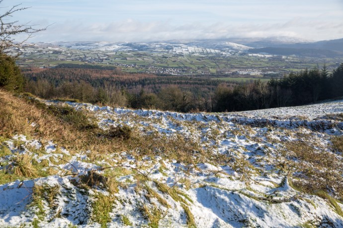
Take Highway 24 west from Colorado Springs. You pass the majestic Pikes Peak (look out for an upcoming blog on this) on your left and after about 50 km you’ll see a turn off to the Florissant Fossil Beds. That sounded interesting so I took it of course. I soon discovered that this place of which I knew nothing (though I should have) is legendary in the annals of American geology and palaeontology.

Within its shales and mudstones is an extraordinarily abundant assemblage of mainly insects and plants dating to the Eocene Period (34 million years old). A combination of unique circumstances has led to a level of preservation normally unheard of for insect and plant fossils.

It’s worth briefly explaining. A lake environment surrounded by redwood forest is determined as the depositional environment here.  A nearby volcano generated volcanic ash which interacted with tiny creatures known as diatoms living in the lake. This caused regular diatom blooms as well as insect and plant die-offs. Dying diatoms would fall to the bottom of the lake and preserve with unrivaled detail the fossils in the finely layered mud and ash. But that’s not all. The volcano also contributed to the formation of some of the finest petrified stumps you will ever see. I’ll come back to that.

You can’t see the fossil beds. They are off limits but there is an excellent display in the museum on site. Invertebrates dominate with over 1,500 species of spiders and insects alone having been identified. Not possible to photograph them properly in their glass cases, so here are a few images from the published scientific record to give you some idea of the quality and depth of the material.

What most people go to Florissant for though is the petrified forest and this you can see.  I’ve always been fascinated by petrified wood. I had a specimen as a young child and I used to count the rings and look under the lens at the cell structure preserved in stone and I would marvel.  Who knows it may have been responsible for firing an interest that saw me spend a lifetime in geology.

IG3C9325

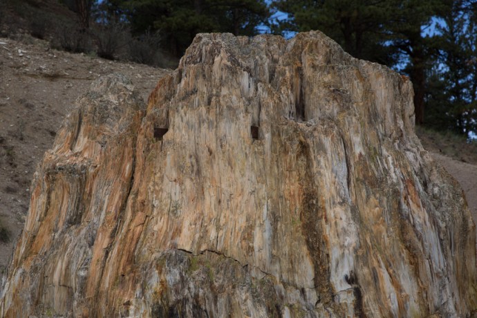
A large petrified stump near the entrance to the park

The Big  Stump.230 feet tall 750 yrs old when covered by volcanic mud

The famous ‘Big Stump’

IG3C9335

The celebrated Trio of redwood stumps

The petrified trees here are among the largest surviving in the world. They have been identified as similar to modern sequoias.  They were killed by a giant lahar (volcanic mud flow) from that volcano we were talking about earlier, flowing through the forest and cutting off the oxygen to the roots. Circulating water containing a lot of silica then percolated through, replacing the organic material in a process known as permineralisation.  The trees were as tall as 60 metres and up to 700 years old when they died.

But I always look for the story behind the story. There is quite a saga here with the discovery, development and preservation of this national treasure; not least because it was owned by an entrepreneurial family, the Singers. I felt personally obliged to investigate this connection further.

But let’s start a little before this, back in the mid 1870s.  Charlotte Hill and husband Adam, acquired and built a homestead near Florissant in 1874 under the Homestead Act. This remarkable woman discovered the fossil beds and collected hundreds of specimens which she brought to the attention of the scientific community. Included in her collection were dozens of previously unrecognised species. Most famous is the spectacular Persephone Butterfly (illustrated above). This led to scientific expeditions but also alerted the world and brought tourists and collectors. Charlotte facilitated this as a guide and joined the many who became collectors and traders in fossils. The Florissant beds were heavily exploited during this time and immense damage done. Thousands of specimens were lost. There was even an attempt to saw up the Big Stump and transport it west; you can still see evidence of this today.

IG3C9433

Saw blades lodged in the “Big Stump’.  An attempt to slice up the tree for specimens.

Then came the railway and thousands of tourists and the pressure only grew.  OK now back to the Singers.  Hill sold her land and homestead and it was eventually bought by the Singer family who set up a tourist attraction around the ‘Big Stump’ Another adjacent landowner opened a second Forest Park with the main attraction being a trio of stumps. They became bitter rivals.

As early as 1915 it had been proposed as a National Park. Some of the owners supported this but the Government was not keen After many false starts, it took 50 years and some torrid court battles for this to become a reality with Singers and the other landowners eventually selling to the Government in the 1960s and the park opening in 1969.

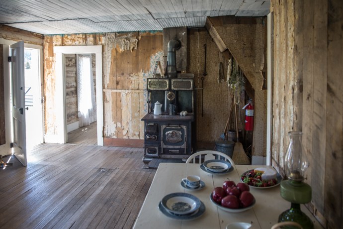
I visited a log cabin nearby. This was the original homestead built by Charlotte and Adam Hill in 1874 and which became the family home of my namesakes, the Singers in the 1920s.  A comfortable cottage giving us a revealing insight into homestead life in the mid west. The walls are lined with layers of newspaper and wallpaper covering many decades. Near the roof line you can see exactly how thick this layering became. Outside the elegant cabin has v-joints and caulking to keep out the icy winds. A central stove heats the whole house.  There is a small kitchen and living areas downstairs and a large bedroom and more sleeping accommodation within the roof upstairs.

It felt just a little bit weird walking through this house that may have been lived in by distant relatives.

The homestead is part of the Fossil Park and well preserved and can be visited if someone happens to be around to unlock it for you.

IG3C9685

The homestead built by Charlotte Hill and later the Singer family home.

IG3C9718

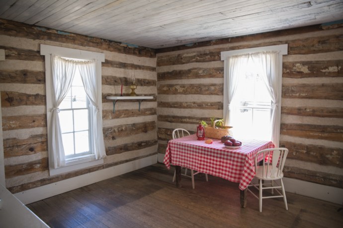
Inside the Hill homestead

IG3C9723

IG3C9772

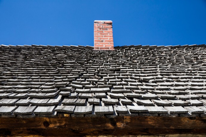
Roof shingles on the Charlotte Hill homestead

The geologist in me wanted to see the fossils in situ but of course that was impossible; but seeing those massive petrified trunks was remarkable enough and the Colorado Rockies delivered yet another amazing experience.

And finding another group of Singers with links into the geological world! Now I wonder if any of them played the fiddle .

Categories: America, My Journey | Tags: , , , , , , , , , , , , , , , , , | 1 Comment

One Day. Six Counties. A Winter Tour through East Ireland

It’s a long drive from West Clare, my base in Ireland, to Carlingford in County Louth.  In fact it is across the country from one coast to the other.  So when you get there you want to maximise the time. Early in February a small festival known as Feile na Tana is organised by renowned fiddler Zoe Conway and she manages to attract some of the finest traditional musicians in the country.   I posted on this festival on my blog a couple of years ago (here) and nothing much has really changed.  Centered on instrument workshops the focus of the festival is on reaching out to the young and to try and restore and invigorate a once strong musical heritage on the edge of Ulster. The other thing I love about coming to Louth, the smallest county in Ireland, is that it and the neighbouring counties of Armagh and Down has unrivaled beauty and such unique landscapes, geology, ancient archaeology and recent history.   I relished the chance to explore this while playing music at the same time.

I was blessed on a number of accounts this time.  The weather was relatively fine (let me translate: ‘it didn’t rain’) and I found a marvelous place to stay through AirBnB.  Eve, another expatriate drawn to leave her life in the US behind and put down roots in Ireland, was the perfect host.  With views toward the Mountains of Mourne and in the shadow of Slieve Foy, I could come and go, I could practice the fiddle or settle down by the fire. And then she was instrumental in convincing me to stay an extra couple of days to experience the coming snow.  Thanks Eve.  I was well rewarded for that decision.

And that’s what I want to talk about in this blog.

IG3C1568

Looking from Louth across to the Mountains of Mourne

IG3C1572

Slieve Foy near Carlingford

IG3C1626

Carlingford nestled at the foot of the Cooley Hills

Coming from the Land of the Midday Sun (I’ve just renewed my Poetic Licence!) I have little experience with snow.  Except that I love it and the spectacular images that may result if the light is right. This lack of experience however led to some interesting learnings about coping with ice and snow on the road

In West Clare when it rains or hails you certainly know about it. The sound of the rain on the slate can be deafening. Here if it snows at night you sleep through the silence. The flakes drift to the ground steadily and quietly building up anywhere where gravity is only mildly resisted.  This is what happened on the Monday night. After an unusually undisturbed night snuggled up with the thoughtfully provided electric blanket (surprisingly unusual in an Irish BnB),  I looked out the window in the morning, with no great expectation, but was dazzled by brilliant blue sky and a sparkling carpet of fresh white powder. And remember I was at sea level.

I had a loose plan. I would take the ferry across the Carlingford Lough to County Down and explore the Mountains of Mourne, which I could see from the window of my second story bedroom.

IG3C1593-Pano

Looking across the Lough from Greenore towards the Mountains of Mourne

IG3C1666

View across the Carlingford Lough to the town of Warrenpoint

IG3C1670

Another view across the Carlingford Lough to the town of Warrenpoint

However the best laid plans. The ferry was closed for ‘adverse’ weather conditions. Hardly surprising really with a strong wind now making life difficult and whipping up the waters of the Lough. In Ireland you always have to have a Plan B, so I drove north towards  Slieve Gullion.   Lucky really as in retrospect driving through County Down would have been treacherous.

My vague plan was to revisit some spots on the Ring of Gullion but really I was dictated by which roads were passable.  I had earlier spent a couple of days exploring this stunning area of South Armagh .  A blog on this is on the way.  I was curious to see what this ancient world looked like under a white blanket.  My route took me through Carlingford to Omeath and up to Flagstaff Hill. Mistake. There were stunning views on the way up.   But.

IG3C1638

The Cooley Hills between Carlingford and Omeagh

IG3C1657

Rock and Ice

IG3C1696

View across the Newry River to County Down on the way up to Flagstaff Hill.  The tower house on the River is the Narrows Keep and the site of the most deadly attack in the Troubles, by the Provisional IRA in 1979, which killed 16 British paratroopers.  

My car struggled to deal with the icy hill and only after some hair raising moments did I make it to a relatively ice-less part of the road to pause.  Up ahead the road continued to climb with even more ice and snow.  What did they say about discretion and valour?  So I did an 11 point turn and gingerly pointed the car back down the hill.

IG3C1705

IG3C1718

Flagstaff Hill is actually in County Armagh.  But are they miles or kilometres?

Having got this far though I decided to walk to the top of the hill.  So glad I did.  I actually didn’t realise that this was Flagstaff Hill which I will talk about in another blog but the snow certainly added another dimension.  Flagstaff Hill is actually in Northern Ireland.    There are no border signs so you don’t actually know.  In fact the only way you know you have passed into another countyr is that the road signs and Google Maps switch to miles.  Honestly I can’t conceive of an hard border here.

The fine white powder transformed the green rolling hills of the elevated Cooley range into an Alpine wonderland. The biting wind and an outside temperature of 1 degree though did nothing to dampen spirits.  I actually didn’t want to leave but I was worried about how the car would handle the trip back down the mountain.

IG3C1755

View down Carlingford Lough from Flagstaff Hill

IG3C1790

View across to the Mountains of Mourne from Flagstaff Hill in Armagh

IG3C1784

Flagstaff Hill

It was nerve wracking I have to say.   Slipping and sliding with shuddering and totally ineffectual brakes I edged back down the hill to Omeath and then on to Slieve Gullion by a more circuitous and less treacherous route.

Naively I had expected to be able to drive to the Summit but luckily the road was closed because I might have been tempted to give it a go.

Thwarted again, I made my way west to a castle I had visited a couple of days earlier (Castle Roche).   Only a light dusting of patchy snow remained at this lower level but this is one of the most imposing ruins in Ireland and the patches of snow added to the mystical quality of the fortification.  I will have more to say about it in my upcoming blog on the Ring of Gullion.

IG3C1818

Castle Roche

IG3C1932

Fields surrounding the Castle

Suddenly the blue skies weren’t blue anymore and snow showers would sweep across the fields.  Not enough to settle and they were only intermittent but they reminded me how quickly the weather could change.

IG3C2010

A dark sky looms over a bucolic winter scene

IG3C2037

Moments later snow sweeps in 

IG3C2061

By now it was approaching 2 pm and  as I had to be back in Clare I reluctantly headed south.

But my adventure was not over.  Driving down the M1 towards Dublin the snow continued to blanket the cuttings along the motorway. Skirting Dublin on the M50 and then south west on the M7,  I could see plenty of snow in the distance and I just couldn’t bring myself to speed past it.

IG3C2169

Snowy hills around Kilteel in Co Kildare

IG3C2177

A rural scene in County Kildare

So so I left the Motorway at Rathcoole in County Dublin and headed east, I had never been here and had no idea where I was going. I love that.  The only thing on my mind was to get closer to those white hills.  My confused route took me through the west of  Dublin to Kildare and then crossing into the edge of Wicklow.   If anything the snow was heavier here than further north and there were unrivaled picture postcard views of snowy villages and of winter landscapes revealed around every corner.  The ranges in the distance I later discovered were the Wicklow Hills.

IG3C2118

Kilteel, Co Kildare

IG3C2134

A snow covered barn in Kilteel, Co Kildare

IG3C2192

The charming village of Rathmore, Co Kildare

IG3C2220

Great weather for sheep.  Co Wicklow.

IG3C2240

Abandoned farm buildings, Co Wicklow

IG3C2271-Pano

Co Wicklow

IG3C2303

Co Wicklow

IG3C2312

Co Wicklow

IG3C2314-Pano

Something was drawing me on but common sense intervened.  As the bright blue sky turned orange with the disappearing sun, and darkness descended, I headed back to the Motorway.  Continuing to Limerick, as if to tease me in the fading light, drifts of snow reflecting in my headlights, continued to tantalise .

A marvelous day and indeed a rare day and I think I took full advantage.  I manged to experience and observe snow-draped winter terrains under largely blue skies across Six Counties – Louth, Down, Armagh, Dublin  Kildare and Wicklow.

Special.

Categories: My Journey, Real Ireland, Wild Ireland | Tags: , , , , , , , , , , , , , , , , , , , , , , | Leave a comment

Connemara Colours. Winter in the Maumturks.

Sometimes you get lucky.

On a Saturday late in November I made a quick trip to Galway to attend a concert in a friend’s house in the heart of Connemara. Now as readers of this blog will know I love the many moods of Connemara and relished the opportunity to spend a little time there. The weather is not always kind however.  You can expect mist on six out of ten days. But if you spend enough time in this surprising country occasionally you are well rewarded.

I had heard reports of snow but had no real expectations. I was not prepared for what awaited me though as I drove a circuitous route in and out of Galway and Mayo between Lough Corrib and Lough Mask.

Near the village of Cong (famous for its association with the Quiet Man, but I will be quiet on that for the moment),  I saw snow on the ranges to the west.  So of course I headed in that direction along the shore of Lough Mask until I reached the village of Finny.   The white shrouded backdrop above the little yellow church were now within reach.  These are part of the Sléibhte Mhám Toirc (or the Maumturks).  Not so well known as the Twelve Bens, which lie on the other side of the Inagh Valley, they are less rugged but with their brilliant white caps reflecting the sizzling sunlight they were no less spectacular.

As the sun and clouds and rain and mist fought for dominance an amazing winter palette was in full display.  Everything contributed.  The sky, the hills, the snow, lakes and rivers, stone walls, pastures and paddocks.   The snow caps would change from grey to dazzling white and then glow golden orange with the descending sun.  The sky was at once black then blue as the storm passed, the hills were orange, brown, red and green.  The country sparkled.

I was lucky and happy.  To be in such a stunningly beautiful place where a world class vista was around each corner.  And so grateful that I could capture some of those fleeting moments with my Canon.

Words are irrelevant.

IG3C8848IG3C8859IG3C8887IG3C8927IG3C8969IG3C8992IG3C9024IG3C9061IG3C9070IG3C9078-PanoIG3C9100IG3C9122IG3C9181IG3C9213IG3C9232IG3C9248IG3C9255IG3C9269IG3C9275IG3C9310IG3C9336IG3C9347IG3C9366IG3C9381IG3C9401IG3C9408IG3C9427IG3C9433IG3C9462IG3C9514IG3C9529IG3C9555-HDRIG3C9690IG3C9717


Categories: My Journey, Real Ireland | Tags: , , , , , , , , , , , , , , | 2 Comments

Blog at WordPress.com.